I did just speak to Michael Fish, he says I can be the woman from Scotland rather than Wales this time who asked, Is a hurricane on the way. He's been very busy chatting about the 30th anniversary of the Great '87 Storm which will be on Monday 16th, so I've drawn his attention to #Ophelia, just in case.
Hurricanes, (also Tropical Cyclones and Typhoons) form over the warm waters of the tropics, as a TD Tropical Depression, then TS Tropical Storm (winds 38-73mph) and can reach Hurricane status with sustained winds over 73mph, not gusts, actual mean winds. Force 12, hurricane force winds are 73mph plus and do get mentioned in the Shipping forecasts with Phenomenal Seas. Remember gusts are sudden temporary bursts of stronger winds.
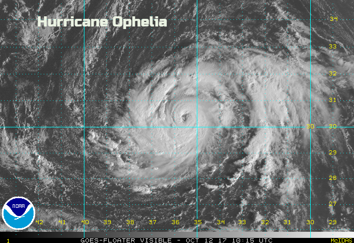
Hurricanes, these towering circulations can reach right up through the lower atmosphere and develop an eye, the cloud-free circle that looks so distinctive and ominous on satellite pictures. The column inside is all about convection and can include clusters of violent thunderstorms around a warm core.
Generally, the overall circulation of global winds steers these cyclones across the sea and then over land where their feed of energy from the warm seas is cut off. They can also just head towards less warm waters. Heading north away from the tropics the seas are cooler, and things begin to change; the transition into a post-tropical low then mid-latitude depression (low). This is a different weather system from the original hurricane but can still unleash powerful winds, torrential rains with dangerous sea conditions.
Extratropical transition is, as its name suggests, a gradual change process in which a tropical cyclone loses tropical characteristics and becomes more extratropical in nature.
Our usual mid-latitude low pressures, which can bring stormy weather and occasionally do the cyclogenesis, “weather bomb” thing and produce a sting jet with destructive winds, are driven by temperatures contrasts. The northern Atlantic can have cool or cold Arctic air up against southern, warmer tropical air. These are baroclinic lows with a cold core, weather fronts and are asymmetric. Temperature contrasts and pressure changes move the lows (eastwards usually) towards the UK, along with interactions with the jetstream. High-level winds add into the process.
Baroclinic zones are favoured areas for strengthening and weakening systems. A region in which a temperature gradient exists on a constant pressure surface.
A hurricane has a warm core, is more symmetrical, without fronts. It is moved by the winds, often the trade winds across to the Caribbean. But they can’t have too much wind at height, resulting in vertical wind shear, as this can wreck their structure. They can have an eye and will either dissipate or change. The extra tropical transition can take place from warm-core to cold core.
There is also warm seclusion; we’ll come back to that.
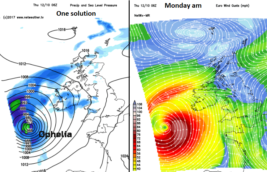
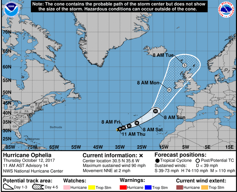
Ophelia has an eye and is a Cat1 hurricane, sustained winds of 74-95mph. The most extreme Cat 5 hurricanes like Patricia or super typhoon Haiyan reached nearly 200mph. Ophelia is forecast to peak at 90mph out in the Atlantic, which it is doing now. So, it is not a monster hurricane but its addition to the weather systems heading towards NW Europe for the start of the new week means there could be severe weather for Ireland and maybe Britain and N.Ireland.
As a cyclone heads north, the underlying seas cool off and colder, drier air creeps into the warm core. The different wind directions and strengths can shear off layers of the cyclone. It will look less symmetrical on satellite imagery. The convective processes within the cyclone fade, and it becomes a different system. As wind shear increases, there will be a broader area of cold topped clouds, the eye and eyewall will disappear, it will begin to tilt. Ophelia looks to hold onto her identity as a low pressure, but her structure will not be that of a hurricane by the time she reaches the UK.
This baroclinic interaction should maintain Ophelia at hurricane intensity through 96 hours, with slow weakening expected after that time as the extratropical cyclone occludes. NHC advisory #14
We often see remnants of ex-hurricane getting swamped by another Atlantic low pressure coming across the ocean. They introduce more energy and the resulting weather system often brings wet and windy weather but with a strange warmth in the air, the tropical leftovers, well mixed up in another low pressure. Forecasters may talk about the remnants of ex-hurricane Bob, but it can be hard to identify anything after the long journey across the Atlantic. Ophelia looks quite distinctive even as it merges with a trailing cold front and moves into its baroclinic phase.
These systems move about much faster. A hurricane won’t usually move that quick. So although nothing can be done to stop the devastation of a hurricane, modern warnings systems do now save hundreds of lives. European forecasters are often faced with fast moving, rapidly developing extra tropical systems with lower confidence in the exact location and timings. Will it get wrecked by the shear and come to nothing, by the time it gets near to the UK, it might be undergoing cyclolysis (decay), the opposite to cyclogenesis, or will it undergo transition and then re-intensify. The following discussion from NHC, US National Hurricane Centre is almost unheard of.
Regardless of the exact track, post-tropical Ophelia is likely to bring some impacts to Ireland and the United Kingdom as a powerful extratropical cyclone in 4 to 5 days. NHC#14
Which brings us back to the other process for a low; tropical cyclone, post or later extra-tropical low, extra-tropical transition and warm seclusion. There are lots of questions surrounding warm seclusion and potential research examples are highly sort after.

An extratropical cyclone can develop warm seclusion. A pool of warm moist air, drawn up into the cold-core circulation but isolated by high air drawn down from the stratosphere. This links to a more modern way of looking at frontal structures away from the traditional Norwegian method, the Shapiro-Keyser model.
"They are characterized by a warm core and a frontal T-bone structure, with a northwestward warm conveyor belt and the effects of dry intrusion. Rapid deepening occurs in the latest phase, around their arrival in Europe. Both baroclinic instability and release of latent heat contribute to the strong intensification. The pressure minimum occurs often a day after entering Europe, which enhances the potential threat of warm seclusion storms for Europe. The impact of a future warmer climate on the development of these storms is discussed.- Mark M. Dekker"
There has been much research into whether Europe will be at risk from more severe weather, deeper lows, more sting jets and even tropical cyclones as our climate and seas warm. Hurricane Ophelia will change before reaching us, this time, but records continue to be broken across the globe, and bizarre out of place weather phenomena are seen that should be sounding warning bells. Will a proper hurricane hit, in the end, one day?
Ophelia is forecast to weaken to Tropical Storm levels at some point on Monday. This means there could still be a post-tropical hurricane just off the SW of Ireland with the transition should take place on Sunday, well out at sea but west of Iberia. Just looking like a technicality.
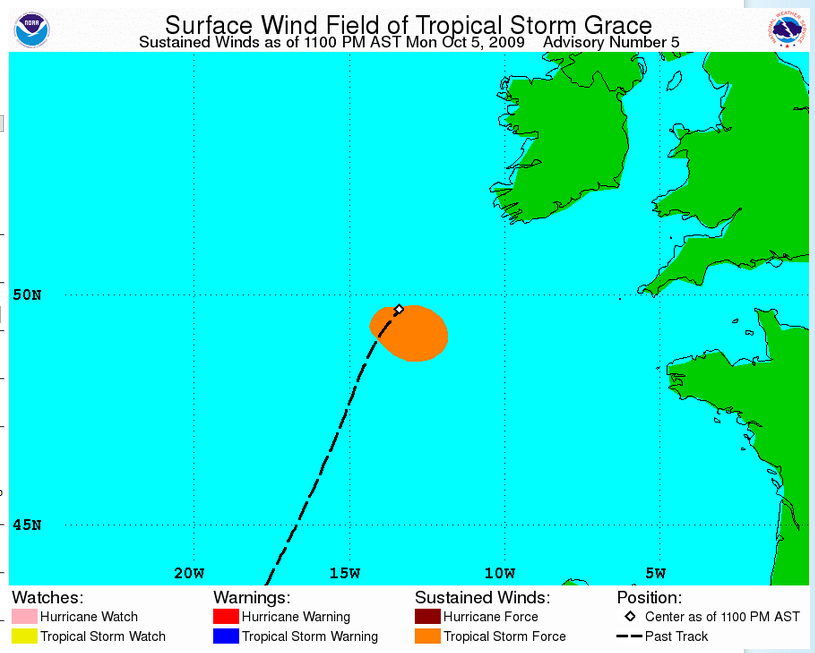
Tropical Storm Grace lasted until quite near SW Ireland back in 2009, Ophelia looks more feisty.
Whatever Ophelia maybe by then, if she stays out west from Ireland, there will be large waves, high seas, heavy rain from the frontal systems and strong winds with gales, even severe gales for western coasts. If she is further east, which some models still show, the winds will impact more land areas, which would be an issue on Sunday afternoon but results in major problems if it is Monday morning.
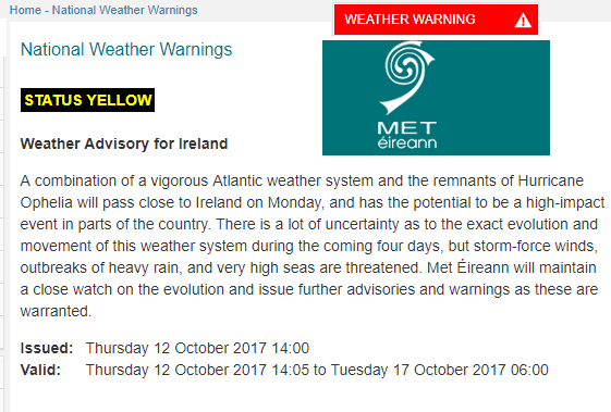
The UK Met Office have also issued a Yellow wind warning for Monday 16th Oct possibly to be extended into Tues 17th.
In the end, if you are in a region affected by destructive winds, and torrential rains, the labelling may not matter. Whatever happens at the start of next week, Ophelia is one very interesting system.
References
Characteristics and development of European cyclones with tropical origin in reanalysis data Dekker, M.M., Haarsma, R.J., Vries, H.. et al. Clim Dyn (2017). https://doi.org/10.1007/s00382-017-3619-89-8 Publisher Name:Springer Berlin Heidelberg Print ISSN0930-7575 Online ISSN1432-0894
Loading recent activity...