Updated 8th December - Covering 15th Dec 2025 - 6th Jan 2026
Mean temperatures are expected to be 1 to 1.5C above the 1991-2020 long-term normal overall in most regions, with a very mild start to the forecast period but temperatures potentially becoming less mild towards Christmas and dropping below normal around the New Year.
It is expected to be wetter than normal in south-western Britain, particularly south Wales and south-west England, where drier weather towards the New Year is unlikely to offset the very wet start to the period. Eastern Scotland and north-east England will probably be drier than normal. Averaged nationally, precipitation totals will probably be near to slightly above normal.
Sunshine totals are likely to end up above normal in most regions, especially the north-east, but may end up a little below normal in some western counties, particularly the south-west.
This period looks set to continue with a very unsettled and mild south-westerly type, with some deep lows moving close to the north-west of Scotland, and thus a likelihood of strong winds, possibly gales at times, particularly in northern and western Britain. The blocking highs to the north and east of Britain will have faded by this point, and so depressions and rain bearing frontal systems will move freely from south-west to north-east across the country. It will continue to be particularly wet relative to the long-term normal in south-western Britain, with sheltered north-eastern coastal areas seeing relatively small rainfall amounts.
There are signs that towards the end of the period, we will start to see the winds become more predominantly westerly rather than south-westerly, with low pressure less strongly dominant to the north-west of Britain and some transitionary ridges of high pressure moving from west to east, especially across southern Britain. This means that temperatures may fall closer to the long-term normal late in the week, with potential for the occasional overnight frost under ridges of high pressure. Widespread lowland snow looks unlikely during this week but there may be one or two days with wintry showers in Scotland from polar maritime west to north-westerlies in between frontal systems, mainly on higher ground, in the second half of the week.
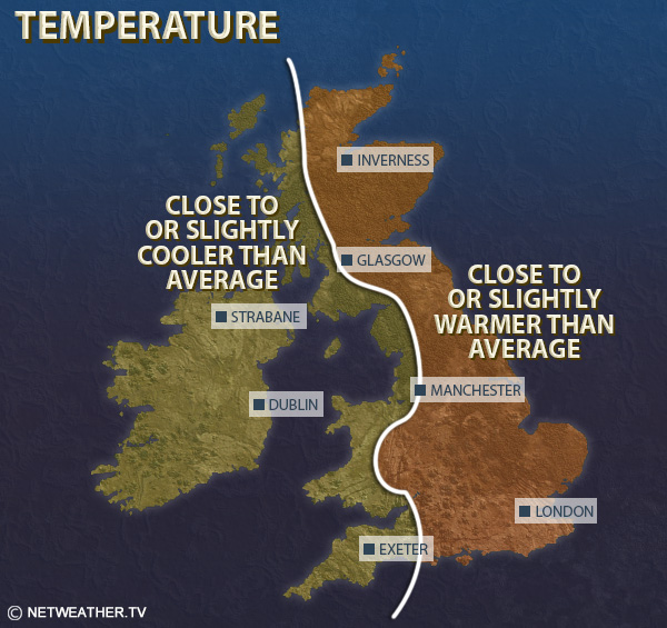
Overall, mean temperatures are expected to be 2 to 3C above the 1991-2020 long-term average across much of the country, although in northern and western Scotland and Northern Ireland, they may end up nearer 1C above.
It will be wetter than normal for most of the country, especially south and west Wales and south-west England, where there may be over twice the normal rainfall in places, creating a risk of flooding. Coastal areas of eastern Scotland and north-east England are the most likely regions to end up drier than average.
Sunshine totals are expected to be below normal in most western parts of the UK, but above normal in eastern Scotland and in coastal north-east England.
This week will most likely have a mix of changeable westerlies and ridges of high pressure, resulting in slightly above-average temperatures overall, but probably rather less mild than the first two-thirds of December, with some frosts overnight.
A white Christmas currently looks unlikely, but is not completely out of the question, as in this weather pattern there can be short-lived northerly or north-westerly blasts, but it looks unlikely that there will be any persistent cold snowy weather and so one of those blasts would have to be perfectly timed to give some areas a white Christmas. The slight potential is greatest in the north and on high ground, with lowland southern Britain currently looking like having a very low chance of having a white Christmas. However, it must be stressed that the likelihood of a white Christmas is generally low and there is a fair chance of the week passing by without any widespread snow events at low levels.
Overall, there is a much weaker signal for this period to be mild and wet, and precipitation totals are most likely to come out close to normal generally, with temperatures probably about 1C above the long-term normal. Sunshine totals are likely to be above normal for most, thanks to clear days associated with polar maritime air and ridges of high pressure.
This period looks likely to be relatively dry and anticyclonic, and there could be some wintry weather at some point during the week via a blast of northerly or north-easterly winds, but there are also likely to be some milder interludes. Generally temperatures are forecast to be close to or slightly below the long-term normal during this period. It is likely to be drier than normal, particularly in western Britain. Sunshine amounts are uncertain due to the potential for anticyclonic gloom at this time of year, but they will most likely be above normal in the west.
Monthly weather forecast
The month ahead forecast is written by Ian Simpson and is updated every Monday.