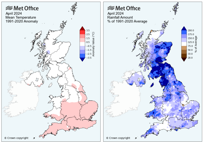
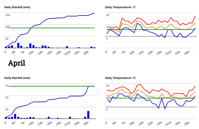
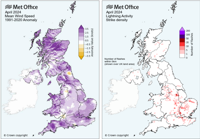
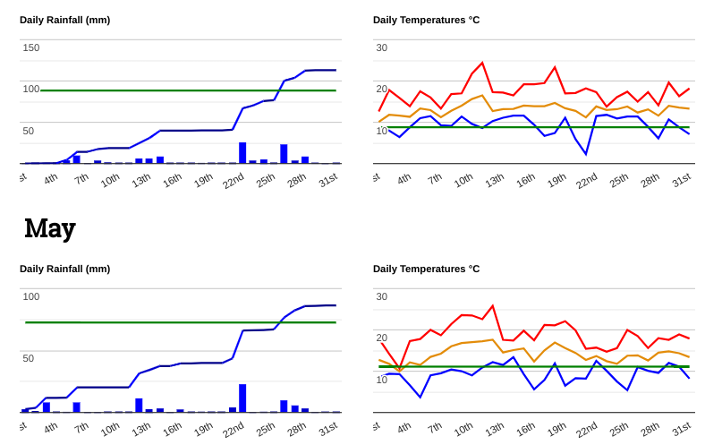
April 2024 was an unsettled, wet month with the traditional April showers but little sunshine. It was dull and often wet. Across the UK it was the sixth wettest April since 1836 and the fourth wettest for Scotland. Northern England was also wet. Temperatures averaged out across the month. The first half was milder than average, particularly in the south and the second half was cooler than average. Storm Kathleen was an intense April low pressure which brought widespread impacts from strong, gusty winds. This was followed by a French-named low called Pierrick which coincided with very high spring tides and brought significant coastal flooding.
The first part of April saw low pressures with showers and frontal rain before high pressure took hold from the middle of the month until around the 26th with colder nights. The end of the month then turned more unsettled with some heavy rain.
The showery weather at the start of the month included wintry showers often for northern Scotland but by the 5th these had reached over northern England.
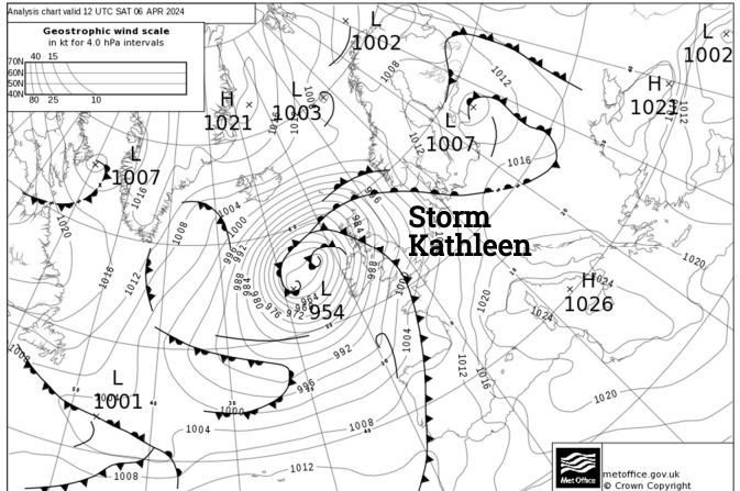
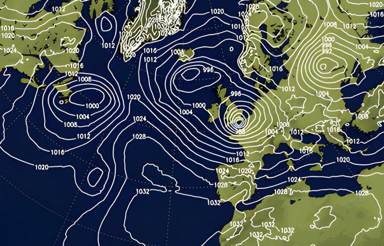
The main event of the month was Storm Kathleen which impacted the UK on the 6th and 7th. Met Eireann had named it for the strength of the winds. It led to many flights being cancelled, Irish ferry services being impacted and disruption to rail services across Scotland. There was heavy rain in Northern Ireland, Scotland, Wales and western coasts of England with many flood alerts and warnings. The ground was already sodden due to the wet weather in the preceding months. It was very mild as warm air was drawn up ahead of the storm and temperatures in eastern England reached 20.9C.
Northern and southern Britain sites (Stirling and Pershore)
Gusts reached 60 to 70mph in many exposed parts as Kathleen developed into a powerful April storm. Loch Glascarnoch in the Highlands saw a gust of 76mph on the 7th and gusts over the tops of the Scottish mountains passed 100mph. For Ireland and Northern Ireland, there were many trees down and power outages as the widespread strong winds continued to rage. The roof of the Titanic Belfast Museum was damaged and the disruption to rail and ferry services continued on the 7th for parts of Scotland.
The Met Office said that Kathleen was an “ unusually severe storm for this time in spring”
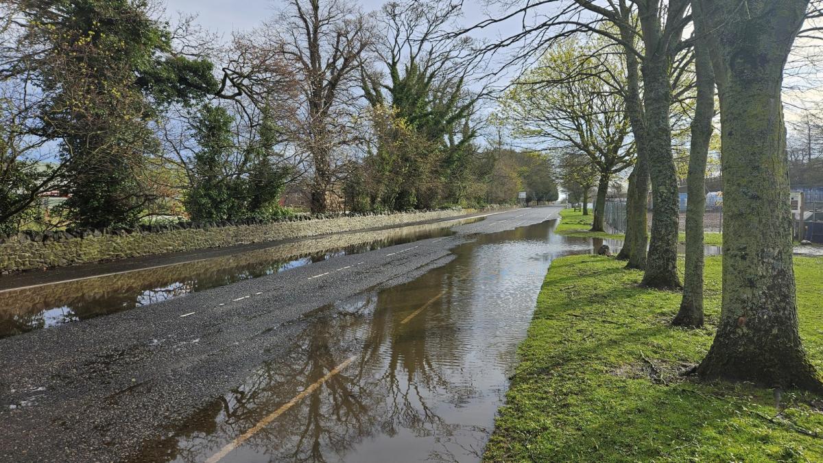
No sooner had Kathleen finished then another low pressure edged up from the southwest. Meteo France had named this storm, Pierrick as part of the southwestern naming group. This low brought more rain and strong winds to the UK at a time of exceptional spring tides. We have seen “Super Moon”s this year and the closeness of the moon to Earth has resulted in several very high tide episodes. During the 8th and 9th there were yellow wind and rain warnings for parts of Britain. Flooding in Littlehampton and Bracklesham, West Sussex where a caravan park had to be evacuated as a river burst its banks. 180 people had to move. In eastern England, Cleethorpes fairground was submerged and in Cornwall, beach huts and benches ended up in the sea. There were problems along the coast in Hampshire, on the Isle of Wight and for Merseyside. Rail services were affected in southern England and on the 9th in NE England along the east coast mainline.
On the 13th it was strangely warm as very mild air flowed up from the south. Temperatures in Essex reach 21.8C.
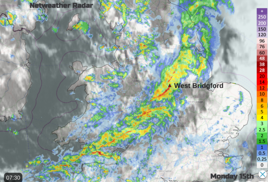
By the 15th it was back to the heavy showers with hail and thunder. It was an alarming (or exciting) start to the day as wild convective conditions arrived. The Netweather forum Midlands group included comments about the sudden drop in temperature and “Proper stormy out there right now” from Solihull. In Derbyshire, there were reports of hail, sleet and proper snow.
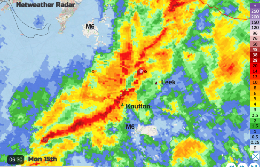
This was the day of the vicious squall line that resulted in reports of tornadic-like damage in the Midlands with fallen trees and damage to houses. Caravans were overturned in Staffordshire, with damage in Leek and Knutton. Roofs were damaged in Derbyshire and many trees were damaged in West Bridgford, Nottinghamshire. From Stoke on Trent “a torrential hail shower, complete with thunder and lightning!”
A more settled spell settled in as high pressure took hold. With clear skies overnight there were reports of air frost and overall the second half of April was colder than average. The lowest temperature was -6.3C in Shap, Cumbria on the 26th. The last few days of the month were wet and unsettled again with wet weather for SE Britain on the 27th and heavy rain for western Britain by the 29th. Cumbria recorded 64.8mm in 24 hours on the 29th and Pembrokeshire 41.4mm on the 30th. Edinburgh had a very wet month with 239% of its usual April rainfall, following double the usual March rainfall and May 2024 led to triple the average rainfall for the east coast Scottish capital.
May 2024 will be remembered for the heavy rain and thundery downpours. It won’t be remembered for being warm. However, May was statistically warm but often dull and it rained a lot. The announcement by the UK Met Office that May 2024 had been the warmest on record did not go down very well in some quarters as it had never felt hot, there had been a distinct lack of several fine, sunny and warm May days. However, it was also the warmest spring on record, dating back to 1884. Northern Scotland was particularly mild compared to average and NW Scotland with Northern Ireland were drier than average in May. Other parts were particularly wet with thunderstorms, squall lines and heavy showers causing damage and disruption before an exceptional wet spell around the 22nd.
Thunderstorms on the 2nd managed to set fire to two homes in Polegate (E.Sussex) as the roof of a care home in Elmer was damaged and Chichester University students had to evacuate their building at 2am when it was struck.
There was damage to railway electricity supplies in Wiltshire and Somerset and fallen trees in Devon closed roads in the area.
The unsettled showery weather continued with further heavy downpours in the first week. On the 6th there was heavy rain and thunderstorms with several funnel clouds spotted over England. Flash flooding in Leeds and Bradford led to travel chaos by the end of the early May Bank Holiday as drivers had to abandon their cars and roads closed. A sinkhole appeared “Water was seen pouring onto the tracks at Horsforth railway station” BBC and the flooding mostly affected areas in the north and NW impacting bus routes too.
High pressure began to build from the 8th leading to some fine, settled weather with fog but declining air quality. This clear spell and mild air coincided with a stunning Aurora show which entertained many people across the UK well into the night.
 John Finney Aurora Lindisfarne May 2024
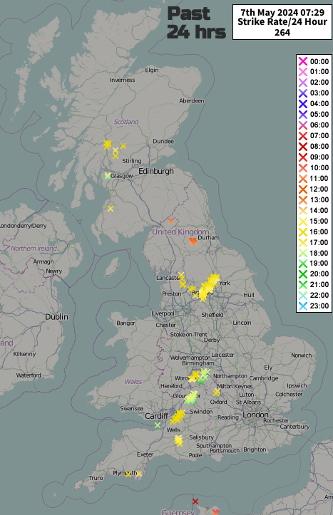
The highest temperature of the month was on the 12th when Chertsey in Surrey reached 27.5C. This warm air was accompanied by active thunderstorms edging northwards over western Britain, and Northern Ireland where there were power outages. The roof at Old Trafford leaked torrents of water as Man Utd played Arsenal. There was heavy rain, puddles on the pitch and a waterfall from the roof
Water also gushed through the roof at Terminal 1 at Manchester airport and further north in Scotland the streets of Greenock became like a river in the thundery rain that evening.
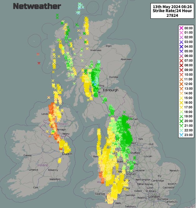 Lightning strikes /Sferics in the 24 hours until 08:26 on 13th May
The weather improved for Scotland just after the middle of the month as temperatures peaked in the mid-20s Celsius. Scotland saw the highest temperatures with Glasgow reaching 25.3C on the 18th.
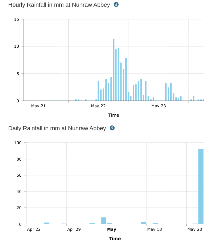
The 21st until the 23rd was an exceptionally wet spell. A low pressure over the North Sea threw a slow-moving front over Britain. It resulted in the wettest day in May for many locations, even their wettest Spring day. Nunraw Abbey in East Lothian saw 100.7mm of rain on the 22nd with the previous record from 1983 being nearly 70mm. Some fallen records were over 100 years old.
There was flash flooding on the North Yorkshire moors and in Cumbria where there was an Amber warning. Between Redcar and Cleveland, there was flooding with cars trapped on impassable roads. Flooding between Birmingham International airport and Coventry led to the railway lines being closed. By the 23rd more rain caused the West Coast mainline to close north of Carlisle.
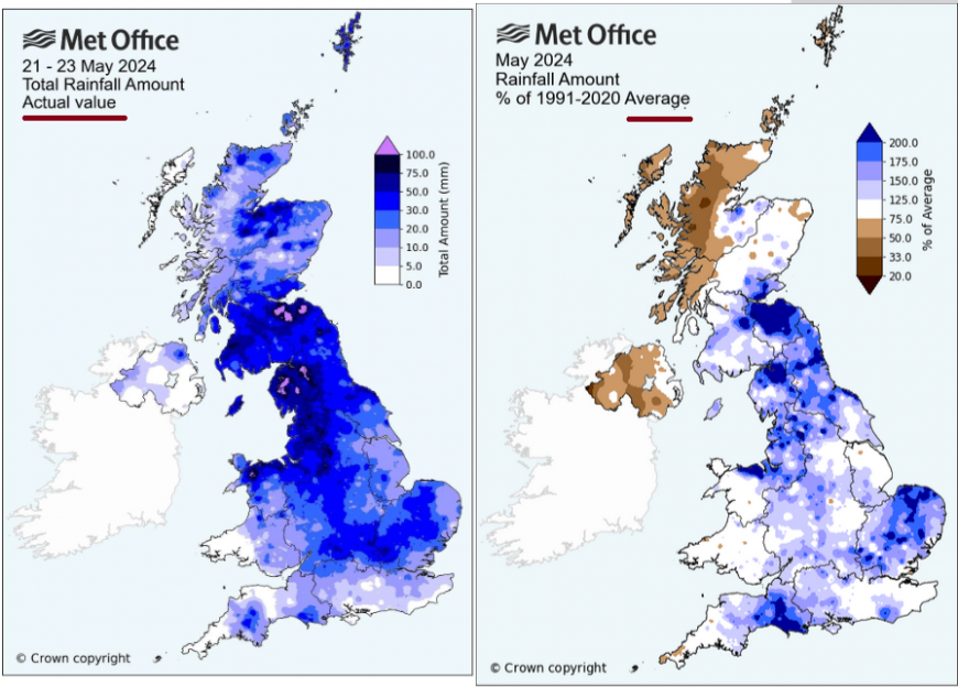
Transpennine Express “we are urging customers not to travel between Manchester, Liverpool, Preston to Carlisle, Glasgow and Edinburgh.” Wellesbourne (West Midlands) saw 62.8mm of rain in 24 hours on the 22nd and Keswick (Cumbria) saw 69mm on the 23rd.
In Cumbria, the village of Stockdalewath suffered severe flooding with families forced from their homes as the river level rose. Emergency Alert - Sent by the UK government at 3:18am on Thursday 23 May 2024 From the Environment Agency.
“ Severe flooding is happening now…in the Stockdalewath Area in the parish of Dalston. Flood waters are expected to rise rapidly. Flooding is likely to cut off the area. Floodwater is a threat to life - do not enter. Remain in a safe location. “
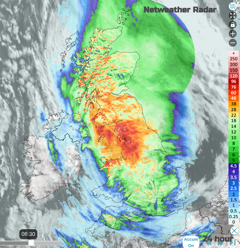
24 hour rainfall totals from the Netweather Radar until 0830 23rd May
That evening the Edinburgh bypass became submerged as over 100mm of rain fell in the nearby hills in under 36 hours. The closure of this main commuter artery caused travel chaos and knock-on impacts for the nearby airport. It was also the 23rd of May when Rishi Sunak took himself outside number 10 Downing Street to resign in the rain. And boy, did it rain.
On the 26th it was East Anglia that saw thunderstorms with disruption between Norwich and Cambridge due to lightning damage to the signalling system.
At the end of the month, there were more heavy showers and thunderstorms leading to surface water flooding.
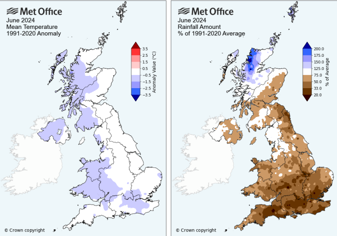
Finally, there was a shift in the UK weather and significantly more sunshine during the month of June. It was dry overall but cooler than average so a change all round from the months before. England and Eastern Scotland were sunnier than average whereas NW Scotland, Northern Ireland and N Wales were still dull. Northern Scotland was wet, dull and windy overall. The first half of the month was cooler than average but June did warm up later.
High pressure helped bring drier weather to the UK although northerly winds in the first week brought showers to Scotland including snow showers to the Cairngorms. The cold Arctic air gave some chilly nights with occasional air frosts in the far north. The coldest night of the month was the 12th/13th when Kinbrace dipped to -1.6C.
The highest rainfall total was on the 13th in Cumbria when 51.2mm was recorded at Mickleden. By the 15th there were lively showers with lightning and a funnel cloud reported in Lincolnshire. A local nursery was damaged when three glasshouses in West Pinchbeck were damaged. The owner estimated that about 1,000 panes of glass were shattered although no one was injured.
From the 23rd until the 26th there was a run of warm days. Parts of SE England reached 28C for several days. The top temperature of the month was 30.5C at Wisley (Surrey) on the 26th. This same heat increased over mainland Europe as the Euros took place in Germany. The weather was mixed for the fans and games with thunderstorm warnings then heat. One game had to be suspended due to the lightning risk.
Eastern and western Britain sites (Manchester and Cambridge)
The warmth was cut off by an Atlantic frontal system moving over the UK. This introduced a cooler airmass for the end of the month.
Loading recent activity...