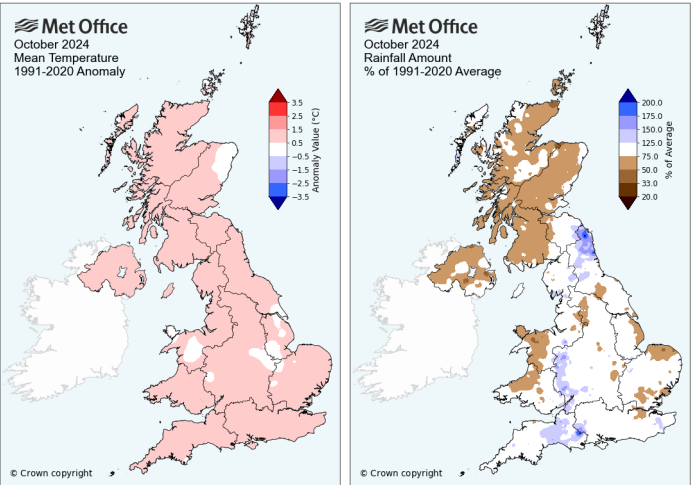
Storm Ashley arrived in October, the first named storm of the new season with rain and strong winds for northern areas. Much of the month was dull, mild and relatively dry. After the rain on the 1st, from a low in the east, there was autumn mist and fog by the 3rd with an air frost in Scotland. This was due to clear skies as Braemer dropped to -4.1C. High pressure brought a settled start to the month. By the end of the first week, it was very mild across the UK on the 7th with temperatures in England in the high teens. On the 8th, there were thundery showers in the south and east of Britain.
The night of the 10th saw another incredible Aurora show across much of the UK, with more red tones than the purples of the May event but another well-timed evening show with fair weather.

The 11th to 13th turned much colder as low pressures moved by although southern areas became much milder for the 16th to 19th. London reached 22.5C on the 16th, the highest maximum of the month and Bude in Cornwall saw overnight temperatures dip no lower than 15.8C.
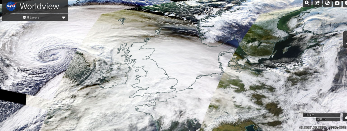
Storm Ashley - named by Met Eireann 20-21st October
“it was a powerful, although not exceptional, Atlantic autumn storm. The storm brought travel disruption to the worst affected areas in the north and west” MO
Ferry services and dozens of flights were cancelled in Northern Ireland and western Scotland due to the strong winds. Rail services in Scotland were impacted due to trees and debris falling onto the tracks. Large waves battered exposed coastlines. Homes lost power in northeastern Scotland and the ten-mile Great South Run in Portsmouth was cancelled.
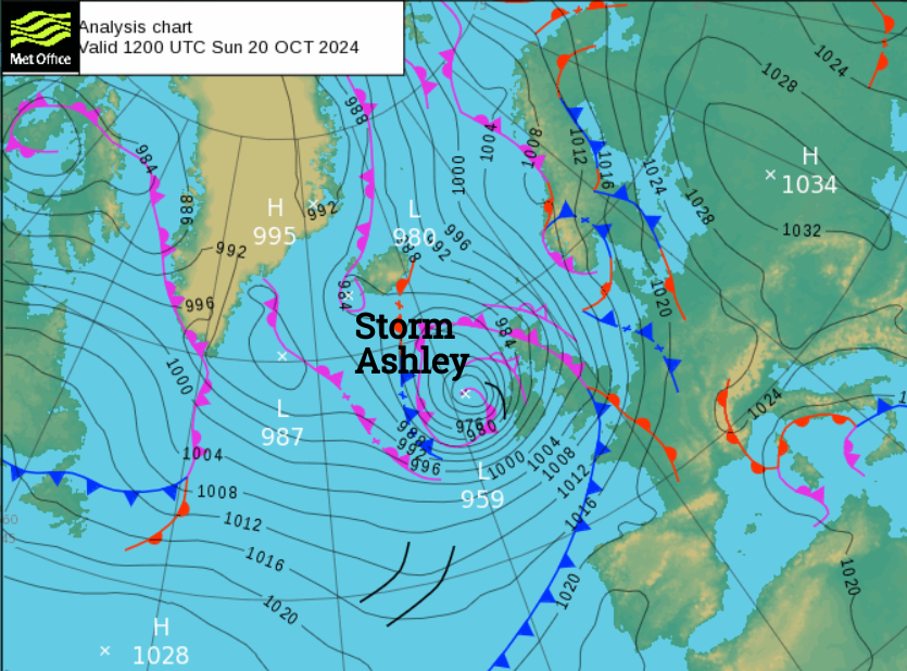
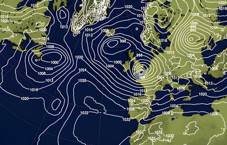
"On the 20th MSL pressure at Stornoway fell from 1003.3 mb at 0000 GMT to 963.9 mb at 2100 GMT - a fall of 39 mb" British Weather diary undergoing ‘explosive cyclogenesis’ as the low rapidly intensified.
The highest gusts were 82mph at Aberdaron Gwynedd, 81mph at Killowen Co.Down and 78mph on Tiree. Up in the mountains, a gust of 121mph was recorded at the summit of Cairngorm at 1237 masl). Five mountain stations in northern Britain recorded gusts in excess of 100mph. There was significant rainfall across Scotland and in the far north of England
The rest of the month was rather changeable as you might expect in autumn. Often mild and breezy but with calm cool nights. The 27th was very wet for Northwest England later in the day and overnight with 74.2mm recorded in the Duddon Valley, Cumbria. By the end of the month high pressure dominated with mist and fog as central and southeastern Britain became colder, grey and quiet.
“November was a month of two very contrasting halves” MO High pressure dominated in the first half and then significantly colder for the second half. Snow closed schools after the middle of the month with disruption to travel and Storm Bert brought heavy rain and strong winds, with south Wales the focus for the severe weather.
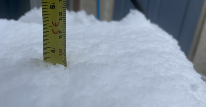
November started settled but gloomy with plenty of cloud cover under an area of high pressure. Northern Scotland became particularly mild on the 6th and the highest temperature of the month, 18.8C in Cornwall on the 10th. For many, it was grey and gloomy, sometimes foggy without significant rainfall. Mid month there was a change to Arctc air with wintry precipitation. It was cold, wetter and windy. Northern Scotland saw snow showers from the 17th but these reached down through the UK by the 19th with a very cold day, even to Central London and the Home Counties. 8 to 15cm of snow was reported for parts of the Midlands on the 19th. There was disruption on the railways and roads in the snow and ice. The University of Derby closed its campuses because of the weather. Schools closed as the winter roads teams were busy gritting and clearing roads
Chesterfield TyphoonNow in the Netweather community forum
Snow also reached through Wales into Devon on the 21st and across the Pennines. This was a significant November snow event. Loch Glascarnoch saw 28cm of snow on the 22nd.
Storm Bert - named by Met Eireann 22-25th November
Storm Bert was named by Met Eireann on the 21st and brought extreme wet and windy weather for Saturday 23rd and Sunday 24th. Businesses before Christmas felt blighted by the weather as severe weather hit on the weekends. Flights from Newcastle Airport were delayed, diverted or cancelled after continuous snowfall on the morning of the 23rd.
The storm brought snow, heavy rain and strong winds causing travel disruption on roads and railways across the country. The West Coast mainline from northwest England to Edinburgh was closed for a time with wider flooding in northern England.
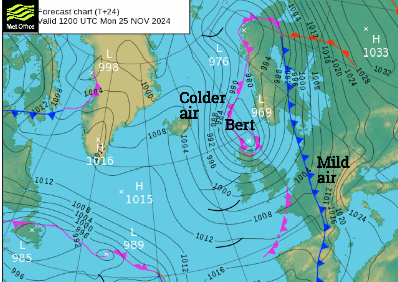
South Wales and south-west England saw over 150mm of rain falling over high ground. There were very strong winds, particularly across south-west England with gusts around 70mph for some inland locations. Capel Curig recorded a gust of 82mph on 23rd November and the UK recorded its wettest calendar day (as an average across the whole country) since 3rd October 2020. Mid-Glamorgan recorded 126mm of rain on the 23rd. Highland Scotland was cold with Kinbrace down to -12.4C by night. There were power outages, flooding with high river levels and a few landslides across Wales in the torrential rain. In Wiltshire, town centres flooded and the UK saw widespread impacts and disruption as five people died in the adverse conditions. By the 25th Bert moved from the Western Isles to the Northern Isles and the summit of Cairngorm Mountain recorded a gust of 113mph.
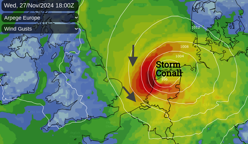
As if all of that wasn’t enough Storm Conall was named by the Dutch Met Service KNMI. Although the main focus was for the Netherlands, the passing low pressure brought further heavy rainfall to central southern England, the Channel Islands and southeast England. The Gatwick Express and Thameslink trains were impacted by further flood warnings.
The UK saw a cold night with frost from the 28th to the 29th before temperatures recovered on the 30th. Scotland had a dry November with an average of 84.3mm of rainfall, 49% less than its usual monthly average
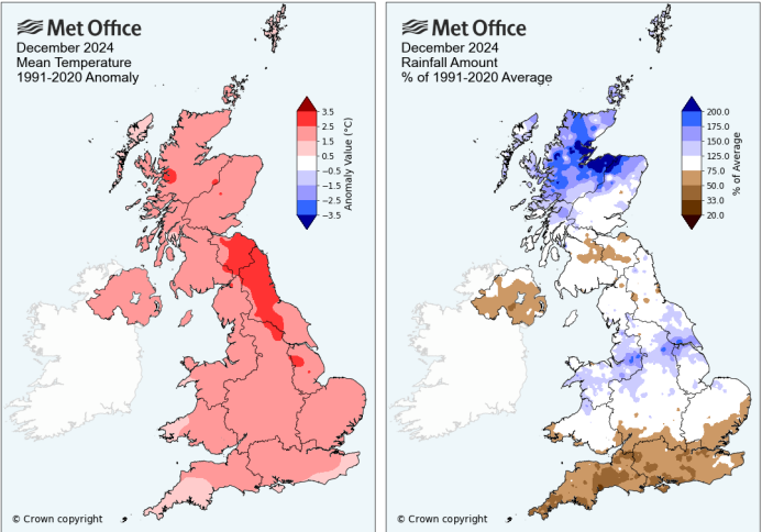
“December 2024 was provisionally the UK’s fifth warmest December on record, in a series from 1884.” MO
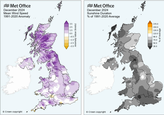
December was mild but the main event was Storm Darragh which brought strong winds and heavy rain to much of the UK, particularly Wales and southwest England. Thinking about the festivities, it will be remembered for a mild Christmas time, with plenty of fog followed by disruptive wind and rain in the run-up to New Year’s Eve. Scotland was exceptionally wet in December.
The month started with mild weather and the top temperature of 15.9C in Somerset on the 1st. Cornwall saw the highest minimum with 13.2C at Bude
“The month started on an exceptionally mild note, with a December average minimum temperature on 1 December of 10.1°C, the UK’s highest December value on record in a daily series from 1960 and the first time 10°C has been exceeded.”
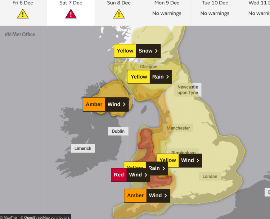
Storm Darragh named by UK Met Office 6-7th December
An intense event with a red wind warning for western Wales and the coasts of the Bristol Channel. It also led to the first weather use of the Emergency Alert text system via personal mobile phones.
Storm Darragh hit on what would have been a busy December weekend bringing more heavy rain and adding to sodden ground, only two weeks after Storm Bert. Leeds saw major flooding on the 5th, Dyfed Powys Police declared a major incident due to the number of calls about fallen trees and incidents on the roads.
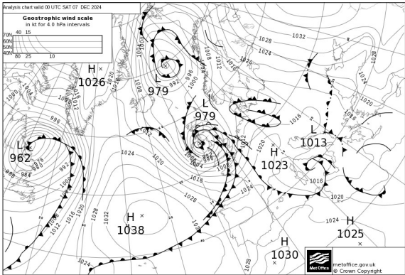
Many events and Christmas markets were cancelled as homes and businesses lost power in the storm. Cardiff council reported more trees fell in Darragh than had fallen in the previous 20 years. Wind damage caused Holyhead Port to close to Irish Sea ferry traffic for over a month. Berry Head on the south coast of Devon saw a top gust of 96mph on the 7th. Unusual northwesterly gales through the Irish Sea tucked behind the low pressure as exposed spots in north Wales saw gusts over 80mph. Football and rugby matches were cancelled as were horse racing events. Many people just stayed at home away from the foul weather.
 Storm Darragh, Exeter by Swebby
The weather turned quieter and cooler until a deep low pressure moved by Iceland on the 18th. This brought gales and disruption to ferry, rail, air and road transport in the far northwest of the UK. South Uist recorded a gust of 82mph.
By the night of December 22nd, there was snow for northern Scotland, Cumbria and the Pennines as a pre-Christmas treat. Less popular with festive travellers were the impacts to travel as London Heathrow cancelled flights due to strong winds and Irish Sea ferry services were disrupted. Christmas Eve was very mild, one of the warmest on record for Northern Ireland. Christmas Day was also extremely mild, reaching 14.2°C at Dyce, Aberdeen, with minimum temperatures in northern Scotland holding up above 10°C. It was largely dry with temperatures in Scotland and Ireland close to 12C.
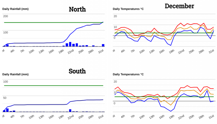
Boxing Day was grey and murky with a blanket of stubborn fog which caused disruption to travel as people finished their Christmas visiting. Manchester and Gatwick airports were affected. 2024 ended with heavy rain and strong winds which impacted New Year’s Eve and Hogmanay events in many parts of northern Britain. Edinburgh celebrations were cancelled as the outdoor stages could not be erected in time, with the inclement Scottish winter weather being blamed. On the 30th rail services were badly affected in the west and flood warnings increased for NW England. Honister Pass in Cumbria recorded 144.2mm of rain on the 31st as several cms of snow fell in the far north of Scotland. Other planned firework celebrations were cancelled as bouts of wind and rain came and went to end the year.
2024
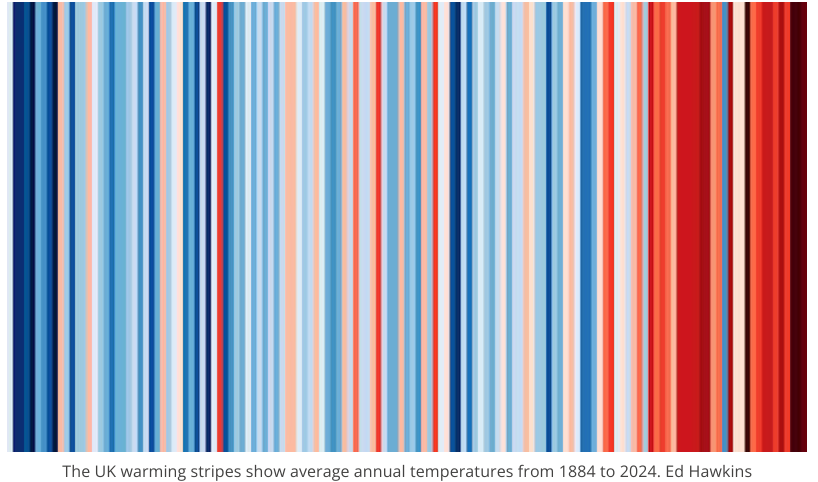
“2024 was provisionally the fourth warmest year on record for the UK, in a series from 1884. All top 10 warmest years according to mean temperature have been since the year 2000, with five in the most recent decade 2015-2024”
2024 has been another year with minimum temperatures well above average. February and December stood out for mild nights and a lack of frosts.
“Last year was the hottest the Earth has experienced since the start of global temperature records in the mid-1800s – and likely for many thousands of years before. The year 2024 was the first in which average global temperatures at the surface of the planet exceeded 1.5C above pre-industrial levels in the majority of leading datasets.” Carbon Brief.
Loading recent activity...