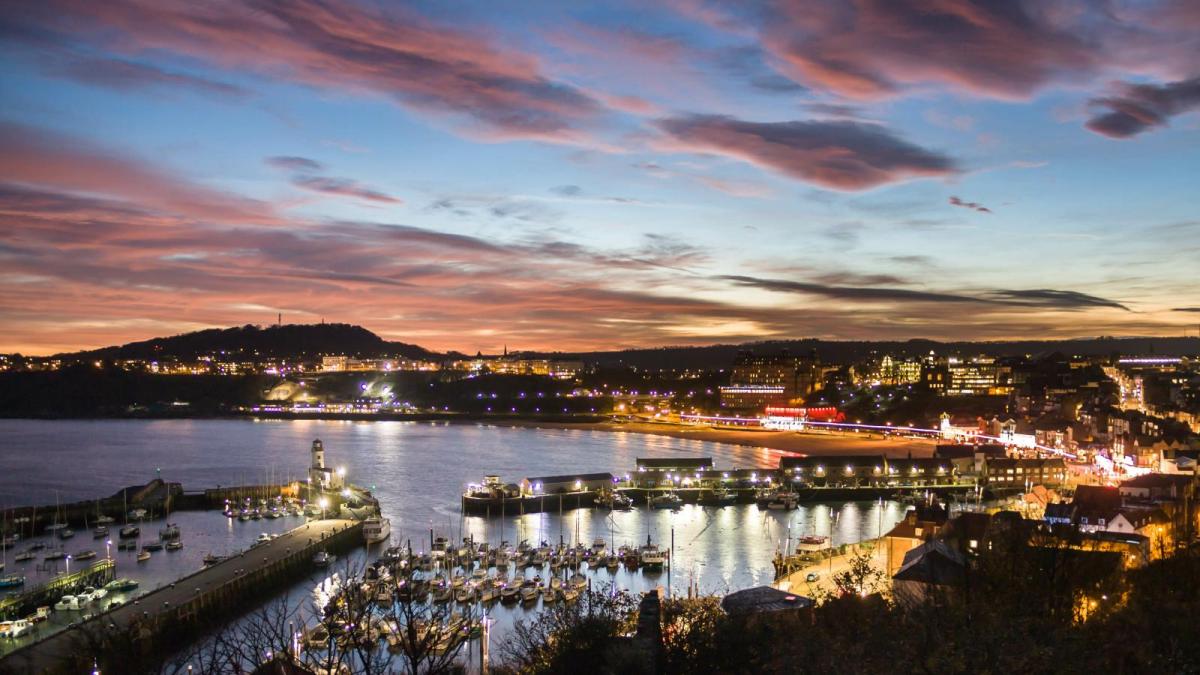
Overall July 2024 was cool and dull. However, the final week was hot, particularly in the southeast. The cooler start did shift to a heatwave by the end of the month. Looking back at spring into summer there was a lack of lengthy heat, nor basking sunshine which made summer unmemorable.
There was flooding around the 10th July and a blip of heat on the 19th but it took a good while for July to get going.
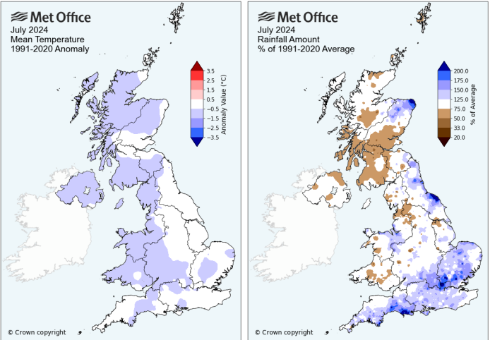
Early on, days varied with a low pressure bringing wet weather to the northwest then in the south by the 5th followed by thundery showers on the 6th. The 7th was a cool day followed by the highest rainfall total recorded in the month, 75.7mm on the 8th at White Barrow in Devon. Thunderstorms and heavy showers impacted Merseyside on the 9th with several roads closed due to fallen trees and flooding. Northeast Scotland was also affected by downpours with nearly a month’s worth of rain falling. Streets were flooded in Elgin, Peterhead and Aberdeen. By the end of the month a few areas stood out as seeing a wet July, NE Aberdeenshire, the North Yorkshire Moors and more widely across east and southeast Britain. As often happens with the monthly statistics, the UK average didn’t tell the whole story. With average rainfall across the UK, some spots saw a wet month.
The 10th to 13th were particularly cool for eastern or northeast England with a flow off the North Sea. The 15th of July is St Swithin’s Day and is supposed to foretell the forecast for the next 40 days. It was wet over southern Britain that day. Finally, a change on the 19th with some summer heat. The temperature leapt up with East Anglia, southeast and central southern England seeing temperatures over 30C.
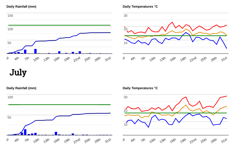
Northern and southern examples of rain and temperature span (Stirling and Pershore)
It was the final week of July that stood out for summer heat as temperatures in England passed 30C. Heathrow and Kew Gardens saw 32.0C on the 30th. There were several hot days at the end of the month although the far northwest wasn’t as warm. High pressure brought the fine weather but there were still thunderstorms in the south. By the 31st there was more warmth in the south after a warm night where some places didn’t dip below 18C but Highland Scotland saw an early frost with clear skies.
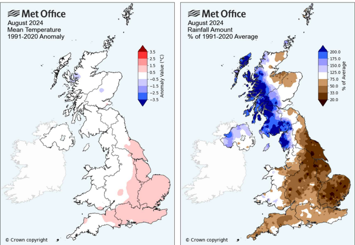
August heat resulted in the top temperature of 2024. There were more heavy downpours and even a named storm. Overall northwest Britain was very wet from the Western Isles down to Cumbria, Northern Ireland was wet but elsewhere was dry, particularly England. Looking at the daily maximum temperatures, eastern Britain was slightly warmer than average, East Anglia was warm and NW Britain was cooler than average underneath the cloud and rain.
August 1st saw an exciting mix of storm ingredients for England with a hot, humid, close feeling of something brewing through the day. Moisture from the south, mid-summer surface heating and plenty of potential energy, There was great anticipation in the Storm and Convective Discussion thread on the Netweather forum as the hours ticked by and the convective development continued. Along the M4, towards Birmingham, and around the Home Counties there was disruptive heavy rain and flooding. Winchester suffered flash flooding as businesses watched the water levels rise and enter shops, theatres and pubs.
On the 12th thunderstorms were linked to fires. In the Highlands, a house was hit by lightning and set alight in the morning in Aviemore. In the West Midlands, three homes were struck by lightning and roofs were set alight. East Anglia and southeast England saw a very hot day. Cambridge reached 34.8C, the highest temperature of the year.
The 21st brought the highest recorded rainfall amount of the month, 154.4mm at Honister Pass in Cumbria followed by a cool night.
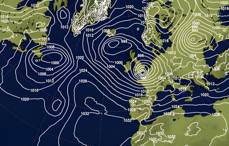
Storm Lilian August 22-23rd
The main event of August 2024 was Storm Lilian. It brought strong winds to England and Wales and parts of Scotland and brought travel disruption ahead of the Bank Holiday weekend. It also impacted Leeds Festival with stages closed and tents damaged.
There were power outages in NE England and train services were disrupted in northern England. Some flights were affected at London Heathrow and there were many flood warnings, especially along the east coast of Britain.
Later in the month, there were some cooler nights and by the 31st there was an air frost in the Highlands as Kinbrace fell to -1.2C
September was extremely wet for some counties of England. Southern England was exceptionally wet with some parts recording their wettest month. There were thundery showers bringing travel disruption and later in the month heavy rain for central and southern England.
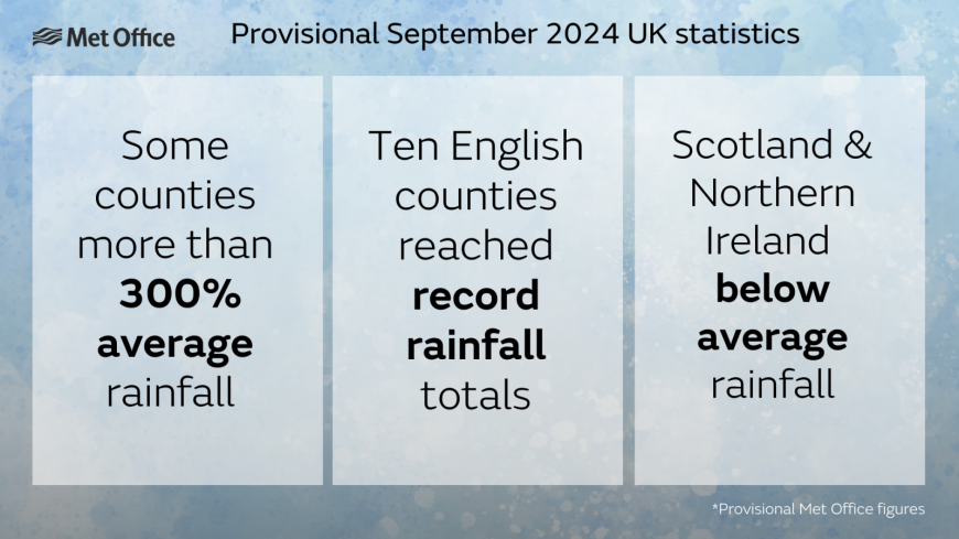
The top temperature of the month was on the 1st, in Cambridge at 30.1C before high pressure faded. As the high moved to Scandinavia, there was an easterly flow off the North Sea. Northern Ireland, Western Scotland, and Cumbria were all drier than average and sunnier throughout the month. Whereas, Wales and England were dull and very wet in parts. Eastern Wales, along with central and southern England.
The 1st was a hot day and warm night, the 6th was hot and that heat remained in the north for the 7th. Colder Arctic air arrived mid-month, with a frost in the north on the 13th but Scotland warmed up again for the 17th to 19th with some fine, dry weather.
For the wet areas, it was grim. Ten English counties recorded their wettest September as Bedfordshire and Oxfordshire recorded their wettest calendar month (since 1836).
Southern England recorded their 3rd wettest September and the wettest since 1918.
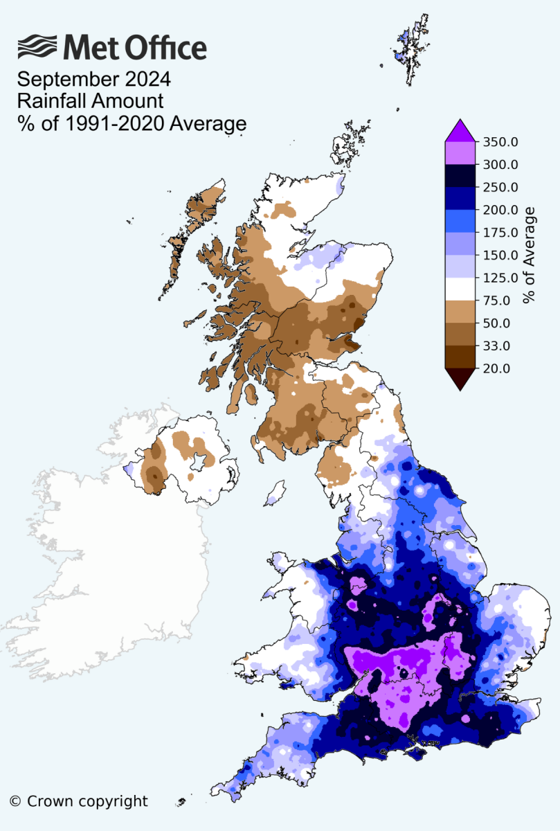
Later in the month low pressure brought bouts of heavy frontal rain. White Barrow in Devon saw 119.9mm on the 29th with strong winds and a gust of 69mph at Berryhead. The jetstream had moved further south and there was a barrage of low pressures and heavy rain, adding to the amounts from earlier in the month.
Loading recent activity...