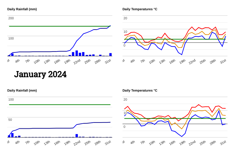
January 2024 saw three named storms; Henk, Isha and Jocelyn. Isha will be remembered as the most significant with many wind warnings, but they all brought impactful weather to the UK and Ireland.
Autumn and December 2023 had been very wet which set the scene for surface water and river flooding early in 2024. Can you remember the muddy ground and footpaths of last New Year in southern Britain?
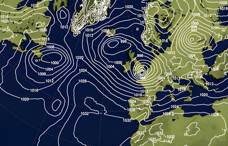
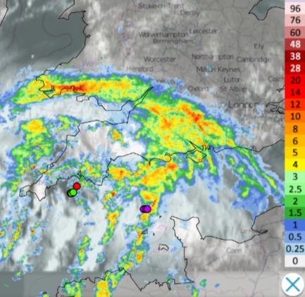
Storm Henk 2nd Jan, was named by the UK Met Office
This brought very wet and very windy weather just after New Year’s Day as many people were returning to work. The focus was on England and Wales. Exeter Airport recorded a gust of 81mph and there were hundreds of flood warnings and alerts. The ground was already saturated and flooding soon became a problem. As Scotland had their extra Bank Holiday Orkney continued with wild winds and ferry disruption as Shetland saw snow as colder air arrived post-Henk. There were also power cuts due to the storm and flooding issues continued that week.
Thursday, 4 January 2024- A major incident has been declared along the River Trent, Nottinghamshire due to the risk of further flooding caused by Storm Henk.
“Notts County Council and its partner agencies are advising residents in areas along the Trent Valley to be prepared for flooding…to ensure they have preparations in place in case they are asked to evacuate.”
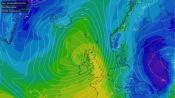
Radar graphs from north and south, Stirlingshire and Worcestershire
After a mild and wet start to the month, it became drier and colder. Northern Ireland saw icy conditions on the 8th and a number of roads were impassable in areas of higher ground. By the 9th, South Wales saw a dusting, light flurries in the wind and graupel which caused excitement

Jersey 9th Jan Photo 'Snowspout'
The Channel Islands saw snow on the 9th in a cold easterly flow with ice warnings as a covering appeared early in the day. This led to the runway at Jersey Airport being closed until late morning.
“09 January 2024 - The Jersey Met Office has issued orange warnings for ice and snow across Jersey and the other Channel Islands.”
Northeast Scotland saw snow mid-month as did northwest England on the 16th of January.
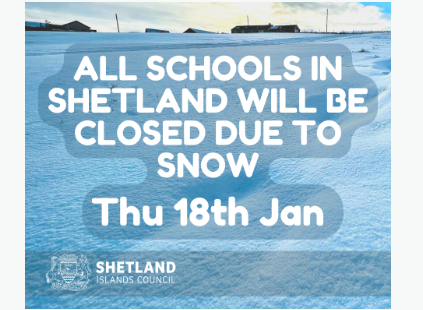
Several schools closed for the day in Merseyside and roads were affected by lying snow and ice. Gritting crews had tried to keep the roads clear but there were still several traffic incidents in the wintry conditions. The lowest temperature of 2024 was at Dalwhinnie in the Cairngorm National Park falling to -14C on the 17th. Shetland saw an amber warning for snow on the 17th and 18th with schools closed and services cancelled in the wintry and windy weather that caused drifting.
Later in January, there was a return to wet and milder weather. Two impactful low pressures rattled in over four days, both becoming named storms. Isha then Jocelyn
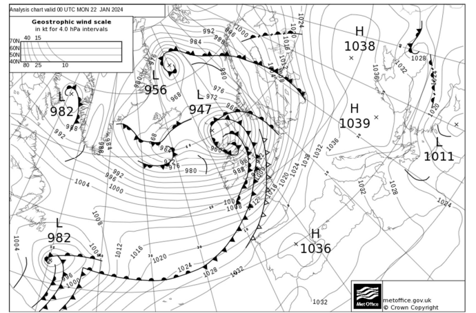
Storm Isha 21-22nd Jan, was named by the UK Met Office. There was windy weather across much of the UK with strong winds for the northern half and a top gust of 99mph for Brizlee Wood, Northumberland. There was a widespread amber warning and a late-night red wind warning for the far northeast of mainland Scotland. Scotland saw cancellations across the rail network, disrupting flights and ferry services in severe gales. Falling trees added to the road chaos with toppled lorries, power cuts and closed bridges. The Met Office said that “Isha was the most significant major wind storm to affect the UK since Storm Eunice in 2022”
As people had barely started recovering and clearing up from Isha, Storm Jocelyn arrived ready for 23-24th Jan. It was named by Met Eireann and overall the wind impacts for the UK weren’t as bad as from Isha. However, the Midlands did experience strong gusts and there was more heavy rain. This added to the sodden ground from the wet season before and the rain from Isha.
A week later a Norwegian named storm, Ingunn affected northern parts of Britain and Northern Ireland. The main fury of the wind was further north with yellow warnings for the UK. Norway faced a rare red wind warning and the Faroe Islands saw a gust of 155mph in hurricane-force winds as the low moved by.
February 2024 was wet and mild for southern Britain with southern England recording its wettest February. Some locations saw three times their average rainfall and East Anglia had its wettest and warmest February on record.
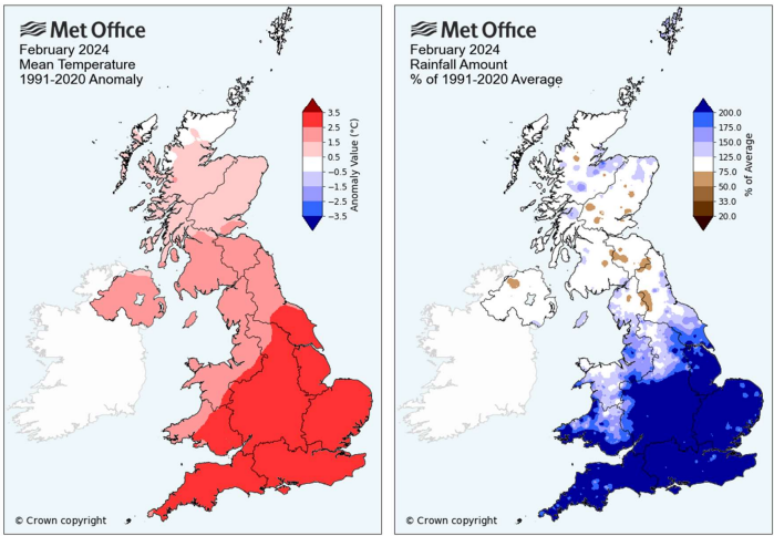
"England and Wales had their respective warmest Februarys on record according to provisional Met Office statistics in what was a mild and wet month for many."
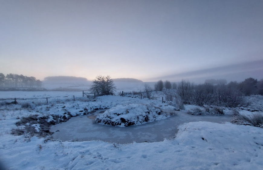
The month started off mild in the south with high pressure nearby. In the north heavy rain caused flooding in the Highlands. Colder air took hold from the north by the 6th until the 8th with widespread rain, snow and ice. A frontal band edged northwards into cold Arctic air leading to Amber warnings. Parts of northern England, Scotland, north Wales and Northern Ireland were affected with some schools closing. There were roads closed over the Pennines and power outages. Kirkwall recorded 15cm of snow in Orkney at 09Z on the 7th and cold, frosty nights followed.
 Snow Sutherland (photo Halfamilefromnowhere)
Whilst northern areas had turned wintry southern Britain became soggy. Heavy rain in the south impacted the railways. There had been ongoing rail strikes but flooding decided to disrupt on several occasions. The railway between Bristol Parkway and Swindon was flooded and all lines were blocked. Lines between Horsforth and Leeds were blocked due to the flooding. In Essex heavy rain and flooding led to people becoming stranded in their cars, requesting help from the emergency services. The rain just kept on coming.
For much of England and Wales, it remained mild but often wet. Pershore saw 18.1C on the 15th as did Teddington in Middlesex.
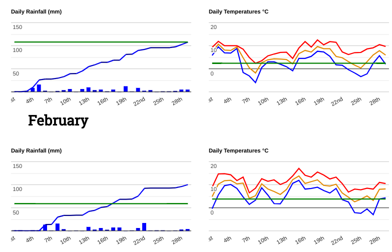
By the 22nd there were more incidents due to wet weather. Dozens of roads were deluged by water after heavy rain. The ground was already saturated and river levels were high.
Great Western Railway services were disrupted in Devon. Other rail services in Shropshire, Worcestershire and Wolverhampton were cancelled due to flooded railway tracks as nearby schools closed. There were numerous flood warnings and alerts with rain warnings from the Met Office.
A European low (named Louis) impacted northern France, the Netherlands, Italy and Croatia but managed to throw more rain over southern England with strong winds as it passed by on the 22nd.
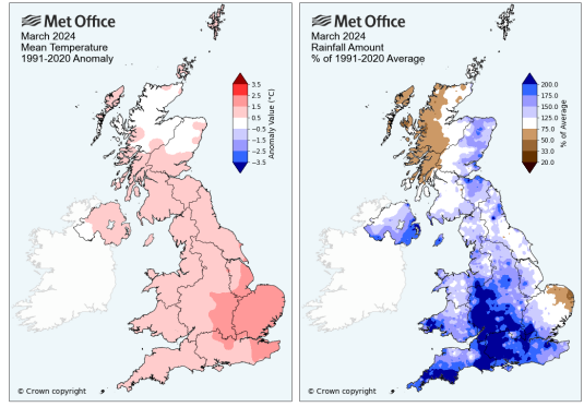
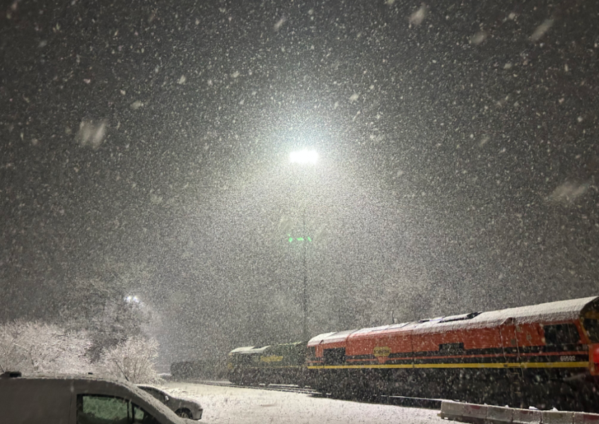
March had a wet and windy start but right through the month, snow kept appearing to remind certain spots that winter had only just faded. There was snow in Northern Ireland on the first day of meteorological spring as a blanket affected Fermanagh, Tyrone and Armagh. This led to difficult conditions on the roads due to slush and ice. Also fallen trees due to the wet snow as southern Ireland saw snow too. Much of the UK was mild in March. It was wetter than average for many areas, particularly southern Britain and the Midlands. East Anglia was drier than average and NW Scotland was drier and very sunny in an otherwise dull month.
In the first few days of March, an area of low pressure brought gusty winds, heavy rain and showers and a grim start to the month. There were sleet and snow showers that reached SW Scotland NW England, the Welsh mountains, with a covering for the Peak District, the Moors and the southern Pennines.
By Saturday the 2nd there was snow for the West Country giving a brief opportunity to go sledging at the weekend. There were delays on major routes such as the M4 and M5 in the wintry conditions and lying snow in Bristol
Somerset 2nd (photo AWD)
More settled weather followed with frost and fog or mist by night. Milder air arrived for the UK on the 12th with heavy rain. Capel Curig, Wales recorded 94.4mm in 24 hours, as more rain added to the high groundwater levels over Wales and Egnland and surface water flooding occurred. High tides with strong winds and large waves led to flooding around Cornwall’s coasts. The top temperatures for the month occurred on the 20th with 18.8C in Carlwood, Surrey and by the 23rd it was back to wintry showers with hail and blustery winds, even sferics for southeastern Britain. More frontal rain for the 25th as the railway lines of SW England were again impacted and flooded.
March 2024 will be remembered for how wet it was, underfoot from the preceding wet weather and from the skies, with endless frontal systems heading our way.
In the final week, a low pressure in the south dominated the weather. A wet easterly flow over eastern then northern Scotland for Wednesday 27th
As people began to think about the Easter weekend a European named storm, Nelson threw heavy rain, strong winds and even snow over the UK for Maundy Thursday.
By the 28th, there was decent snow over Devon with a wintry wonderland for Dartmoor.
Devon County Highways worked through the night to treat roads but asked motorists to “ drive with extreme care, avoid high roads and stick to main roads where possible." Northern Ireland also saw snow and there were wild conditions for SW Britain in the wind and rain.
Loading recent activity...