And we've made it! Christmas is with us, and to tell you the truth, I have now made it official and had my first (small!) sip of Baileys. Now, let's crack on with the final update of the year.
Santa Shaker! ⛄
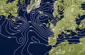
Starting with a look back before we look at the forecast - here is the pressure anomaly map we used on the 15th December, with the one created earlier today below. Not a bad match! High pressure certainly dominant.


A yellow wind warning is in force for South West England and Wales throughout Christmas Day. East to northeasterly winds will gust widely to 45-55 mph, reaching 55-65 mph along exposed coasts and in the lee of the higher hills. Cornwall, Devon, Somerset and much of Wales will see the gustiest winds. Large waves and spray may affect coastal areas in these regions, so think twice before joining any festive dips.
Elsewhere, it's a mainly dry but decidedly chilly picture. Eastern counties from Norfolk down to Kent will see plenty of cloud drifting in off the North Sea, while western Scotland and Northern Ireland fare best for brightness. Temperatures peak at a modest 4°C to 7°C, though the brisk easterly wind, especially across southern England, will make it feel closer to freezing. A warm coat will likely be an essential accessory for a Christmas morning (or after dinner) stroll.

As for snow, hopes of a white Christmas are slim. A few light showers may clip the South West during the day, potentially turning to sleet or snow over higher ground. Similarly a few showers may just drift in off of the North Sea, especially during the early hours of the day, with a hint of wintriness possible higher up. But in both cases, any accumulation is unlikely. For the vast majority, Christmas Day will be green and dry with a touch of frost to start and finish.
Give Santa a shake for a final time this year to find out the current chances of seeing at least a flake of snow in your region and check in on Xmas eve for the last update of the year.
All that's left to do is to wish you a very Merry Christmas. Thank you for following the Xmas forecast this year, it's always a pleasure putting it together.


🎄 Next Update: November 2026 🎅