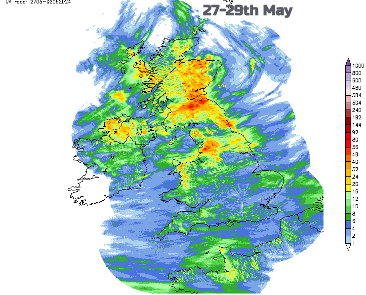
For much of the UK, May 2024 has been very wet, away from Northern Ireland and northwest Scotland.
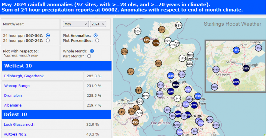
Luton, Rhyl, and northern England from Keswick across to near Hexham have all recorded over 200% of their LTA, (Long Term Average) rainfall. Edinburgh has already recorded 285 % LTA May monthly rainfall with two days left.
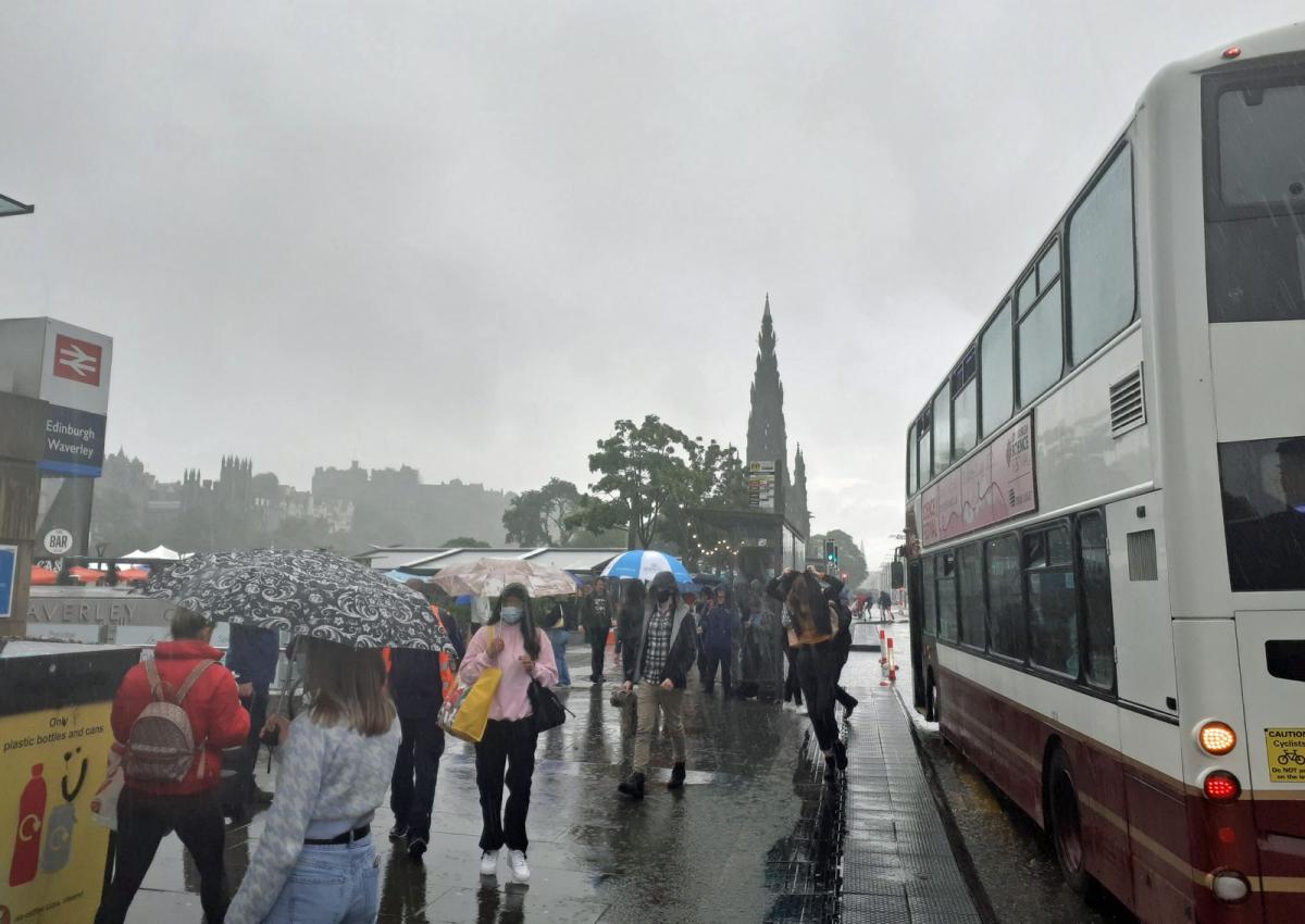
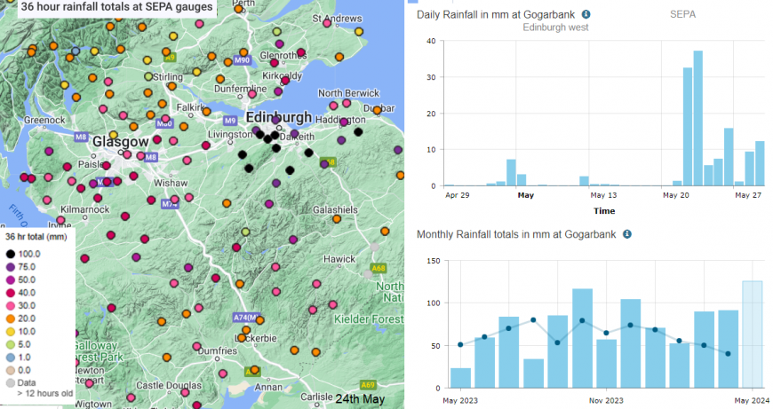
On Thursday 23rd May, the rain just kept on coming. The northern end of the A1 joins the Edinburgh Bypass, a main arterial route reaching south of Edinburgh across to the start of the M8, linking through the Central Belt to Glasgow. By Thursday evening, hundreds of drivers were stuck on the Bypass which had to be closed in both directions. Commuters, long-distance trucks, airport traffic and unfortunate locals were at a standstill for hours in severe flooding. A month’s worth of rain fell in a day and a half in Edinburgh with 111mm recorded in the nearby Pentland hills and 95mm in the Lammermuirs in East Lothian.
Traffic Scotland posted “Delays are causing disruption back to the M8, Drivers are advised to avoid the area at this time”.
https://x.com/trafficscotland/status/1793693008228983252
Persistent, heavy rainfall, significant runoff from nearby fields, and water cascading down the hills that overlook outer Edinburgh all led to mayhem. Water had to be pumped away into the night. River levels in the north of the city were very high with water surging westwards towards Murrayfield, the home of Scottish rugby.
There was more rain to come. The Edinburgh Marathon on Sunday 26th saw thousands of runners braving the pouring rain. Into the last week of May and a rash of showers and thunderstorms continued for eastern Scotland with numerous weather warnings from the Met Office. The bombardment later in the month allowed the rainfall totals to leap up. There have been wider flooding issues through Lothian too.
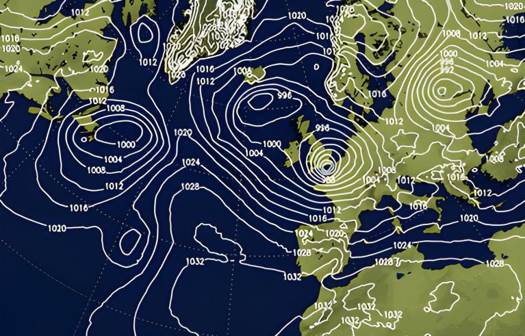
The contrast between southeastern and northwestern Scotland is stark this month. However if one side is wet then the other is often dry, usually the west coast in the prevailing SW wind. In more northerly or easterly flows Lothian, Fife and Aberdeenshire see a lot of rain. The Western Isles and Highland then benefit from more sunshine and drier weather.
Scottish Environmental Protection Agency SEPA has started issuing its weekly Water Scarcity updates highlighting Early Warning conditions for the northwestern region of the mainland. A very different picture compared to soggy Edinburgh.
Statistically, Scotland is divided into climatic thirds, with the eastern area usually seeing around 70mm of rain on average in May. Edinburgh’s monthly average is just 47.6mm at the Botanical Gardens. It is hard for tourists to know what to expect in the Scottish Capital at this time of year. There should be, on average, nearly 200 hours of sunshine. It can be sunny and dry, in 1941 only 8.4m of rain was recorded. However, in 1968, it was very wet with 125.2mm of rain and May 2024 smashed that value with 140mm recorded by the 29th.
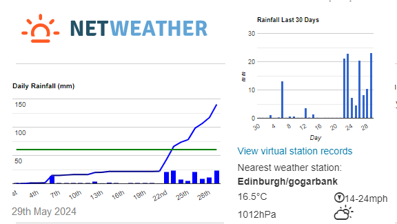
It has been this last week that totals have started to leap up. May 6th saw 15.2mm of rain in one day but the list continues: 23rd 48.6mm, 26th 25mm, 27th 10mm. The 24th and 29th gave the highest UK daily rainfall totals with 21.4mm and 22.6mm respectively.
SEPA said recently that groundwater levels at most monitoring stations were normal or high for the time of year. River flows were also very high in the south and east of Scotland due to the wet winter and spring. The land was already wet and then it started to rain and thunderstorms popped up.
As we near midsummer, there are many hours of daylight. As the sunlight warms the ground in northeastern Britain, air rises as convection begins. The cooler air from the North Sea is unstable and moist, flowing inland, warming up then rising. Daytime heating continues, sometimes with colder air aloft, adding more instability and through the afternoon and evening, up go the thunderstorms.
These have brought torrential downpours and contributed to the high monthly rainfall totals in southeastern Scotland. Inevitably this led to more disruptive flooding.
The outlook in Edinburgh is drier with sunshine on Saturday 1st and warmth for Sunday 2nd. A well-timed change for the weekend.
Loading recent activity...