
A conveyor belt of Atlantic depressions continues to bring unsettled weather to the country, with Storm Bram (named by Met Éireann) the next in line. For the start of the working week however, we're briefly between systems, giving sunny intervals for most with just a few showers, mainly in the north and west. This afternoon sees a warm front ahead of Bram bringing some rain to the south west and parts of the South before dusk. It remains very mild throughout.
Met Office yellow warnings of strong winds and heavy rain are in force for Wales and the south west as Storm Bram approaches from the Atlantic. As a result, the rain in the south will sweep quickly northward, reaching probably all but northern Scotland by dawn. Initially the rain will be patchy before becoming heavier and more persistent from the south through the night.
Winds freshen from the south, with gales developing, perhaps severe, across coasts and headlands of the south west and Wales by morning. But it'll be mild, with temperatures mostly in the range 7 to 12C.
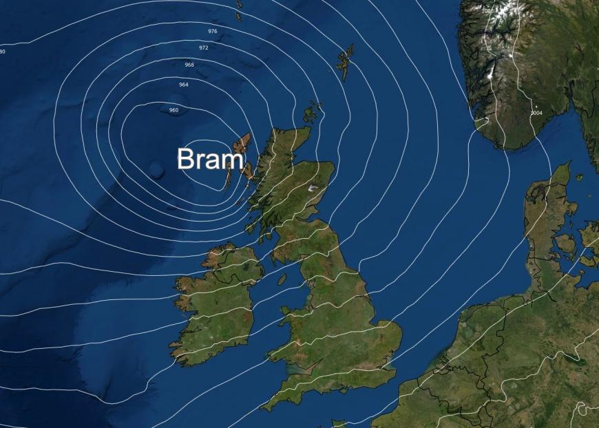
Storm Bram will bring a very wet and windy spell of weather as it tracks across the country. An amber warning for wind has been issued for north west Scotland, where gusts could reach up to 90mph in a few places. Yellow warnings for wind are also in force for Wales and south west England, Northern Ireland, northern England and into southern and eastern Scotland. Yellow warnings for rain cover most of Wales, the south west of England and the Central Belt of Scotland—with the possibility of 100mm falling over higher ground in the south of Wales and parts of Devon.
With this heavy rain falling on already saturated ground, some flooding is expected, which will no doubt increase the number of flood warnings and alerts already in force. A strong to gale force southerly may increase further as the rain turns showery and winds veer south westerly later. More widely, gusts of 50-60mph are expected across Wales, south west England and Northern Ireland, with perhaps 70mph in a few spots. Power outages are possible, with fallen trees an additional travel hazard. Any sunshine will certainly be at a premium, but despite this it'll be very mild, exceptionally so in some areas, with temperatures reaching 16C or so in parts of north Wales, north west England and southern Scotland.
As Storm Bram continues to track northward, it'll be the turn of the north west and west of Scotland to bear the brunt of the storm, but more especially Highland and the Outer Isles where gusts in excess of 90mph are possible within the amber warning area. Elsewhere, strong and gusty winds will be widespread, with severe gales of up to 60mph across much of the north and west.
There'll also be passing blustery, even squally, showers, most frequent in the north and west where many will be heavy, with a risk of thunder especially in coastal areas. But it'll continue to be very mild, with temperatures mostly between 7 and 12C.
Storm Bram will slowly pull away northwards from Britain during Wednesday. In its wake, severe gales continue across north west Scotland into Wednesday, when all parts see a mixture of sunny intervals but also a further scattering of blustery showers, with some more persistent rain in the far north at first. These fade and winds decrease overnight, with Thursday probably the best day of the week. It should be drier and brighter with some sunshine, especially in the east and south, and the chance of a frost for some in central and south eastern parts to start the day.
The rain returns during Friday, with the unsettled weather continuing into the weekend when it may become quite windy again in the north and west. But it will remain mild everywhere, with little risk of frost.
Loading recent activity...


