November had an exceptionally mild first half with persistent southerly and south-westerly winds, but there were colder spells in the second half. Relative to the 1991-2020 long-term normal, it was still a mild month for most of the country, except for western and northern Scotland, but not exceptionally so for most regions. The month ended up exceptionally wet in parts of the Midlands, Yorkshire and Lincolnshire. With 129.4 mm of precipitation, Waddington near Lincoln had its wettest November on record (in records going back to 1949), beating previous wet Novembers in 2000 (a notoriously wet autumn with major flooding around York) and 2019.
Some places had snow around 20 November for the second November in a row. It was not generally as widespread as in 2024, but there were major falls in north-east Scotland, and on the 20th, many counties bordering the North Sea from East Yorkshire northwards woke up to a covering of snow, even out to the sea front. This shows that it is still possible to get widespread snow in November, but there was a general sense that similar setups a few decades ago would probably have brought rather more widespread snow on low ground.
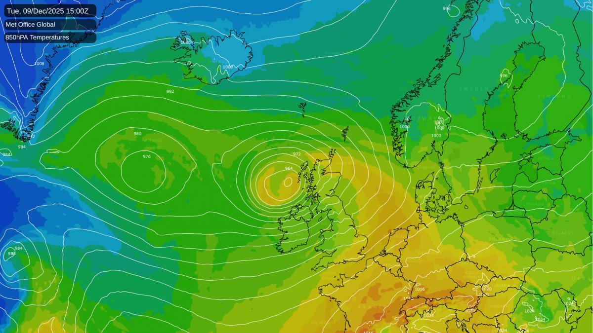
There is still no definite end in sight to the mild and changeable weather with low pressure dominant to the west and north-west of Britain, bringing in mainly south-westerly winds. The ECMWF 42-day forecasts continue to suggest an evolution towards colder and drier weather in late December and into early January, with higher pressure to the north of Britain, but they have been forecasting a shift to colder and drier weather for some time, and it keeps being pushed back as we get closer to the time. It is worth noting that we will have some weak blocking anticyclones to the north and north-east of Britain during the coming week, but that they won't be strong enough to bring colder and drier weather to Britain, with a strong jet stream on their southern flank sending low pressure systems close to our west.
Some have been noting parallels between the current weather pattern and the mild and exceptionally wet winter of 2013/14. December 2013 had a relatively dry first half, although there were storm surges in the North and Irish Seas associated with Cyclone Xaver on 4/5 December, which drew some comparisons with the devastating flooding from a storm surge on 31 January/1 February 1953, but stronger North Sea flood defences ensured that damage from the December 2013 storm was far more modest.
After mid-December, low pressure remained close to the west and north-west of Britain for most of the rest of the winter. There was severe flooding in some parts of the country, particularly in south-west England where the main railway line from Devon into Cornwall was closed for several weeks. The winter was largely snowless at low levels, exceptionally so in some regions, though it was s snowy winter above 600m in Scotland which contributed to relatively high snow patch survivals that year.
I have seen comments suggesting that a mild winter in the UK translates to the cold air staying bottled up over the Arctic, but this isn't always the case. January and February 2014 had some notable cold air outbreaks over North America. In February 2014, Svalbard Airport recorded a mean temperature of -1.7C, 14.5C above its 1961-1990 normal, and low lying parts of Svalbard saw some rain events that month, which has historically been unusual at that time of year.
The ENSO state (with a very weak La Nina event in the Pacific Ocean) and a few other atmospheric variables are also pretty similar this winter to how they were in the winter of 2013/14. This doesn't mean that winter 2025/26 will necessarily stay similar for the rest of the winter, but the possibility is there, it now looks unlikely that the current mild and wet pattern will shift until at least 20 December. There are hints in the medium range forecast models that it might turn less wet towards 20 December with higher pressure developing to the south and south-east, but that type of setup tends to maintain above-average temperatures, so a white Christmas is starting to look increasingly unlikely.
In general, there is potential for this to end up as a very mild December, though it is unlikely to be as warm as the record breaking mild and wet December of 2015.
I noted earlier that the winter of 2013/14 had some notable cold outbreaks over North America. It looks probable that the similar pattern that we have at present will bring some notably cold blasts particularly into the Northeast. The first of these will hit the north-eastern USA during the next few days, although high pressure will quickly build across this region and so snow amounts are not generally forecast to be large.
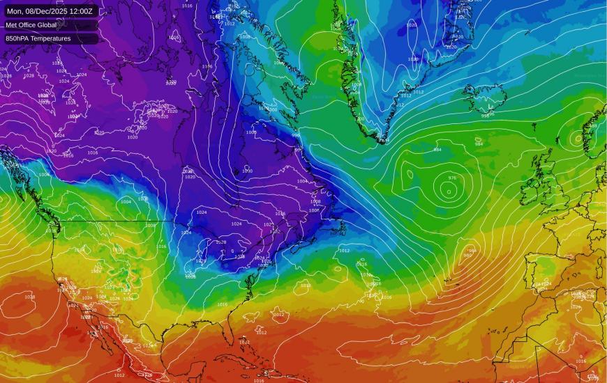
After a milder interlude, there is relatively high confidence in the north and east of the USA having another potent cold air outbreak in about a week's time, which has potential to head a long way south down the eastern side of the USA and to deliver big snowfalls. However, it looks set to stay relatively mild in western North America.
Generally, the north-east of North America is more prone to widespread snowfalls and very low temperatures than the British Isles because Britain is surrounded by seas which moderate the intensity of any northerly blasts, whereas in the USA, with Canada lying to the north, there is very little such moderation over the land mass. Substantial lake effect snow can happen around the southern and eastern flanks of the Great Lakes at the time of year.
Loading recent activity...