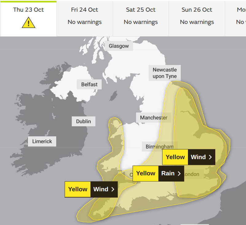
The UK Met Office has yellow warnings for wind and rain midweek as a deepening low pressure moves over England from France. This low has been named by Météo France, as Benjamin.
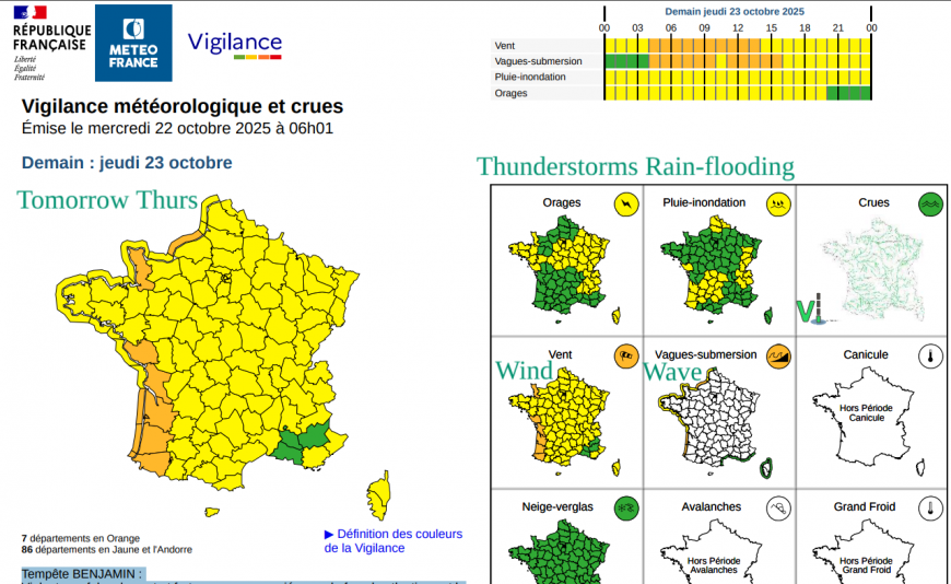
There are orange and yellow wind warnings across France starting on Wednesday night and through Thursday with gales and violent gusts expected. With large tides this week, the combination of strong W/NW winds, the surge of water from the low pressure and onshore, there are concerns about high waves for the Atlantic coast and coastal flooding.
Conditions in the English Channel will be stormy too and this could cause some disruption to ferry services. There will be strong winds across much of France on Thursday with heavy rain in the Northern Alps. This severe autumn storm follows a period of settled weather, much like the UK saw last week.
Why Benjamin, not Bram?
Ireland, the UK and the Netherlands are in a (western) storm naming group together. We have seen Storm Amy already this season, which started in September. Our next name would be Bram. France, Spain, Portugal, Belgium, Andorra and Luxembourg are all in another (southwestern) group. So they have a different list of names. They have all already used Alice for a DANA event in Spain earlier this month. This is a new decision this season to use the communication tool of naming storms to include stationary upper low pressures (Depresion Aislada en Niveles Altos), which can cause persistent rainfall and impactful flooding. The next name on this list is Benjamin, hence Tempete Benjamin.
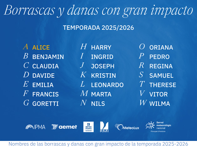
The UK Met Office had decided not to name Storm Bram, and the National Meteorological Services should all speak to each other about these decisions, so Benjamin will perhaps raise awareness of the wet and windy weather as this low moves over England.
“Strong winds may cause travel disruption and some damage across eastern England during Thursday.” MO
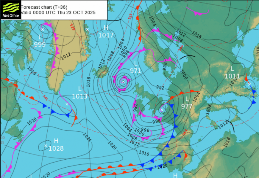
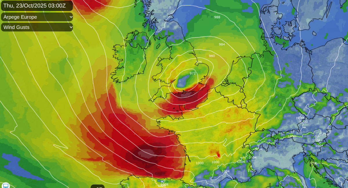
There have been concerns about the strength of the winds for eastern England as this low pressure deepens and pulls away over the North Sea. The models have fluctuated a lot. This uncertainty is still mentioned in the yellow wind warning ‘Further Detail’
“A deepening area of low pressure is expected to cross southeast Britain on Thursday, clearing into the North Sea by Thursday evening… There is a smaller chance, should the low be deeper, that wind gusts of 65-75 mph may develop for a time very locally, this most likely late morning and into the afternoon.” MO

The winds will strengthen for the far southeast of England coasts during Wednesday night, particularly for Kent and then there will be a tuck of northerly and northeasterly gales for north Norfolk and The Wash early on Thursday. England, Wales and Northern Ireland will be windy by midday on Thursday, but it will be East Anglia breaking the brunt of the wild weather as well as around the Thames estuary and for north Kent. It will stay very windy for eastern England into Thursday evening.

Storm Benjamin will also bring heavy rain, to SW Ireland and southern England on Wednesday evening. Depending on how the low develops overnight, this rain will spread over more of southern Britain, up to eastern England and will accompany the strong winds around the Wash for the start of Thursday. Conditions on the roads will be miserable, but there could be a slight shift in the worst-affected areas, so think about the whole event.
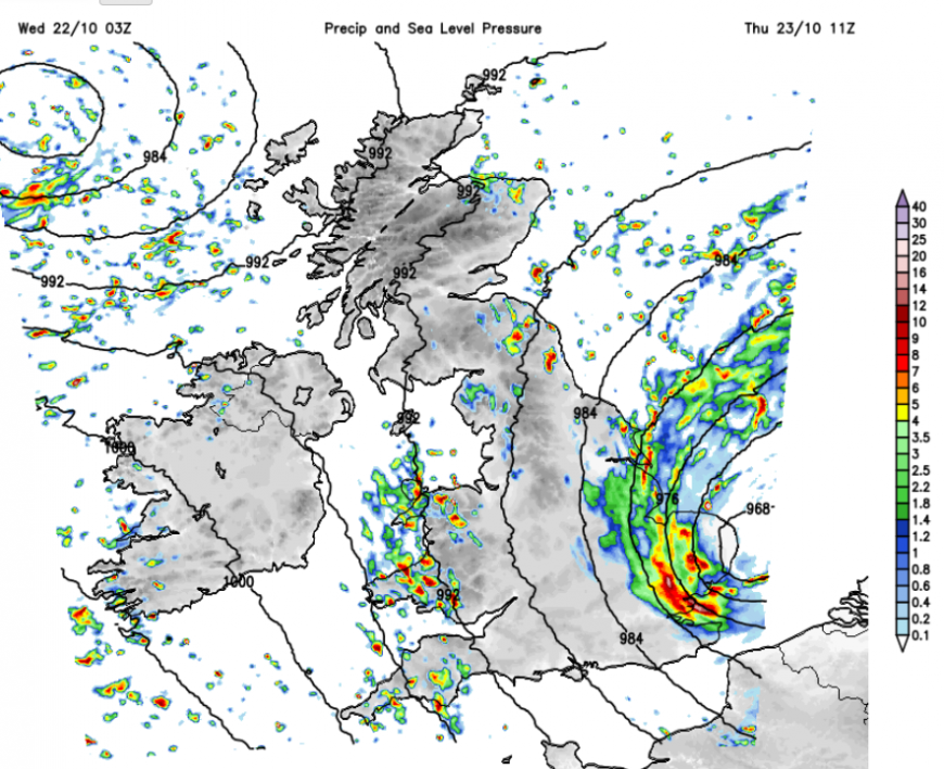
The UKV Model has more heavy rain for eastern England with the low centre nearby by Thursday lunchtime and clusters of heavy showers elsewhere with some bright spells in the west. Heavy rain could affect NE England on Thursday afternoon and frontal rain could reach back to NE Scotland early on Friday as the same low pressure rotates over the North Sea to end the working week.
Further discussion about the uncertainty around this low
Loading recent activity...