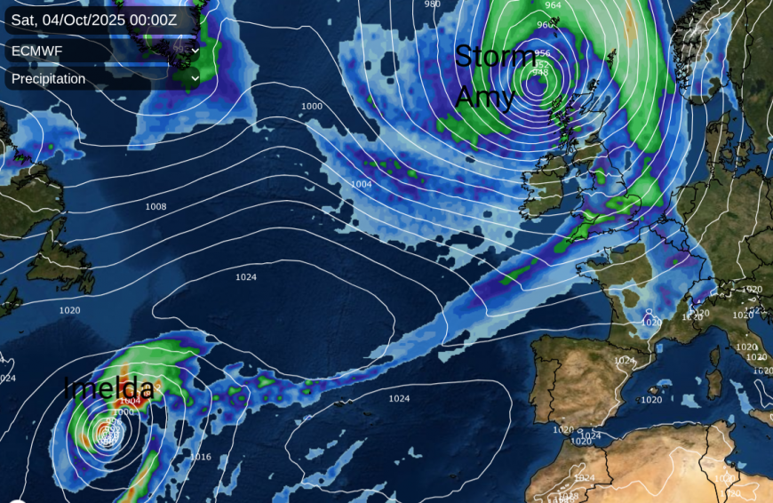
The first named storm of the 2025/26 season will be Storm Amy, arriving on Friday. The UK Met Office has named a low pressure which has links to a complex tropical setup in the western Atlantic, involving two hurricanes - Humberto and Imelda. As Imelda swamps the fading Humberto midweek, a new low will form ahead of this and get caught up in the jetstream. It will forge its path towards NW Europe, moving into an area of development and rapidly deepen to bring a stormy Friday night for the far north and northwest of the UK.
Wind and rain feature strongly in the forecast for the second half of this week. There are still parts of the UK crying out for sustained rainfall to replenish water supplies after months of dry weather. With Atlantic low pressures heading our way, it is the western areas which will get a soaking with less rainfall in the east. It does stay mild though, even feeling warm for sunny southeastern spots.
The main focus in the forecast has to be on Storm Amy, which will come close to or over Scotland during Friday night but it won’t just be the strength of the winds causing impacts.
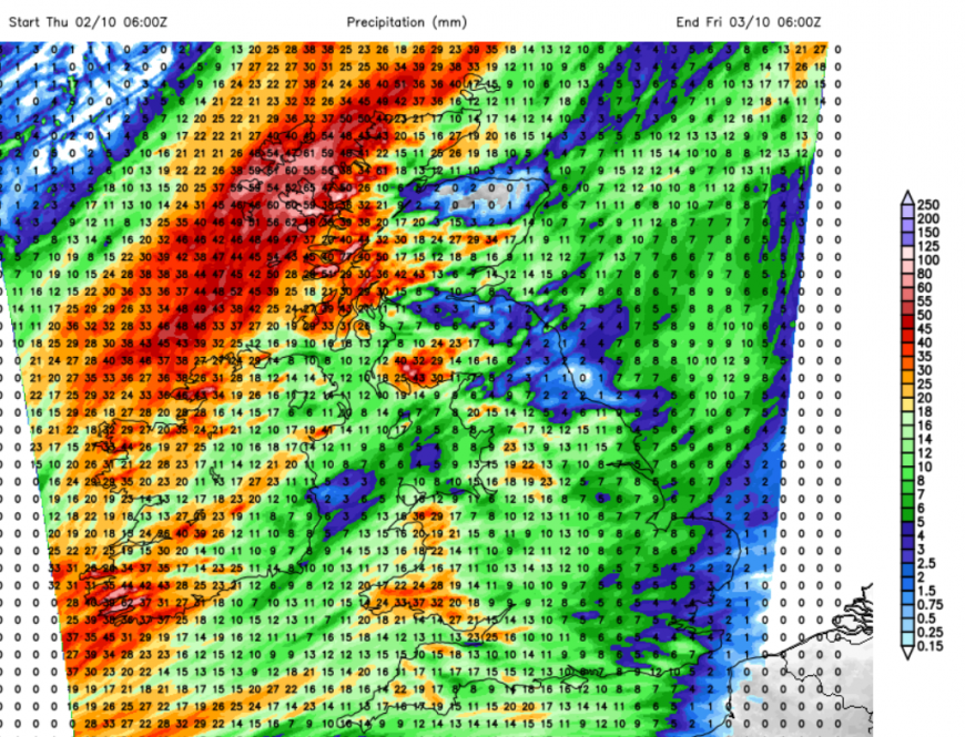
Heavy rain for NW Scotland during Wednesday night and Thursday, before Storm Amy arrives
Western Scotland has a heavy rain warning from the Met Office from Wednesday evening through Thursday as “Persistent, heavy rain may lead to transport disruption and flooding.” In the Scottish Flood Forecast from SEPA the “potential for flooding impacts across western areas from surface water, small watercourses and larger rivers” is mentioned even before Friday’s main low. This sets the scene of very wet weather over the Western Isles and western Scotland before Amy arrives and wet conditions for the high ground in the western half of the UK. This first bout of wet and windy weather does move across the UK during Thursday evening and night, pulling away from Kent and the Northern Isles early on Friday. That is just the warm-up.
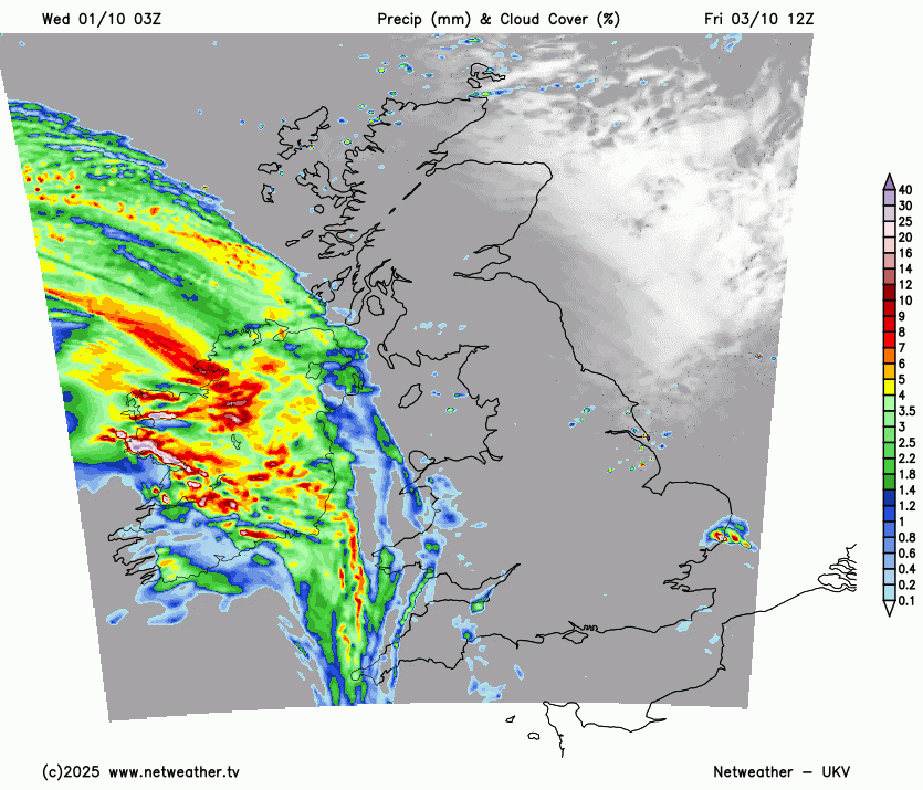
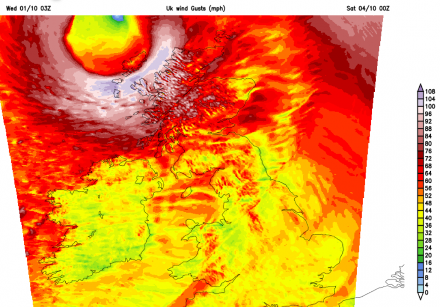
UKV model forecast of rain from Storm Amy, Friday pm into Saturday 4th
Frontal rain will arrive over Northern Ireland and then western Britain during Friday afternoon and evening. The heaviest rain moves over northern Britain, particularly for Cumbria and then clears away over the North Sea but with outbreaks of rain over Wales and England during Friday evening. The following cold front shows signs of line convection when sudden, vicious rainfall with gusty winds can make driving conditions very difficult with poor visibility.
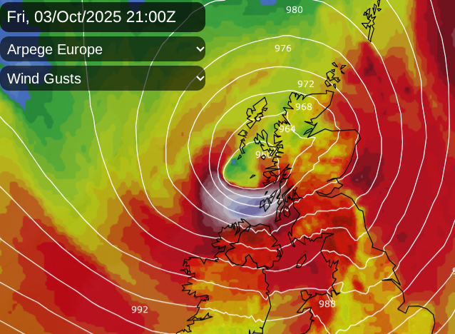
There is still some variation in the detail for Friday night, shown here with the core of strongest winds between the Arpege and UKV models. This could be why there are not Amber warnings just yet.
There will be a lot of surface water and spray, flooding issues look likely for western parts, particularly western Scotland and the winds could reach gale, even severe gale force for exposed parts around the low centre and over high ground. This will be during the evening and overnight, so most people should be able to get out of the way of the worst of the storm in the north. The naming of storms is a communication tool to help raise awareness of upcoming severe weather so that people can adapt, prepare and think about changing their plans.
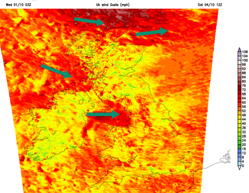
Saturday looks windy everywhere as the wind veer to a westerly with the storm continuing for the Northern Isles. The winds should ease over southern Britain later on Saturday with plenty of sunny weather here and a rash of showers further north. These will move by quickly in the wind. It will be clear during Saturday night with a sunny start for Britain on Sunday. Cloud will increase from the west on Sunday with patchy rain for western counties but staying fair for much of England and not as windy. Still blustery for Scotland in a westerly but nothing like Friday night or Saturday.
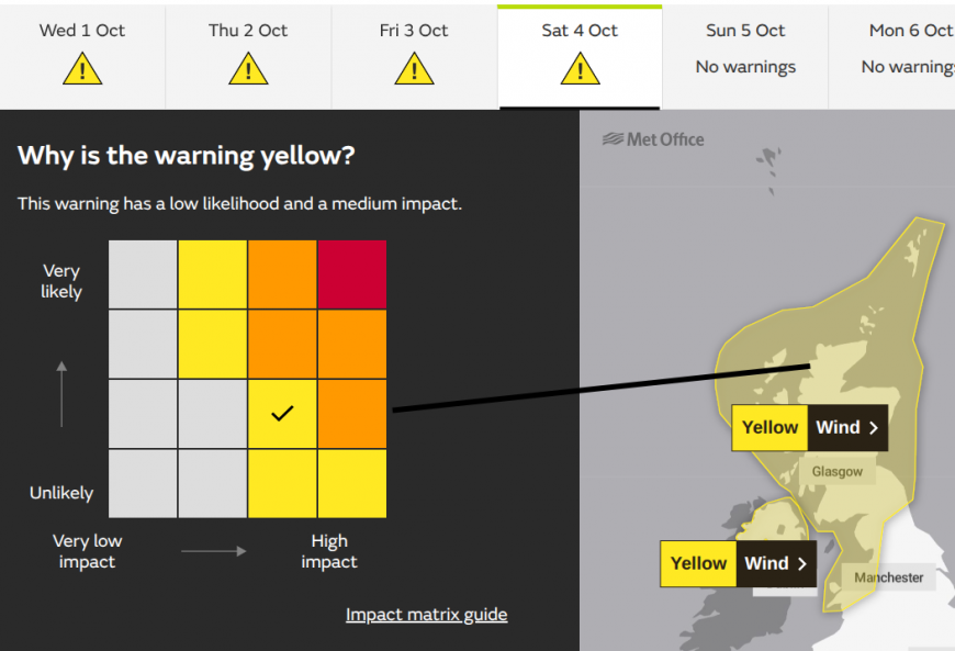
There has been some uncertainty about the path of Friday’s low pressure due to its links to the complex duo of hurricanes. The wording of the two yellow wind warnings continues this uncertainty.
“Storm Amy is likely to lead to disruption during Friday and Saturday.” over Scotland, northwest England and north Wales.
“Storm Amy may lead to disruption during Friday evening and overnight.” Northern Ireland.
The stormy weather will likely warrant an amber warning later in the week but there needs to be more confidence around which areas will be impacted the most and when. Overnight Friday into Saturday won’t impact as many people as Friday evening, when many people will be trying to travel, especially by ferry around Scottish coasts and across the Irish Sea. Also, for the rail network, after the heavy rain during midweek and road bridges could be affected.
Met Eireann has issued a yellow wind warning for Ireland "Storm Amy: Strong to near gale force and gusty southwesterly winds."
More discussion on Storm Amy and will it be windy where you are?
List of storm names for 2025 and 2026
Loading recent activity...