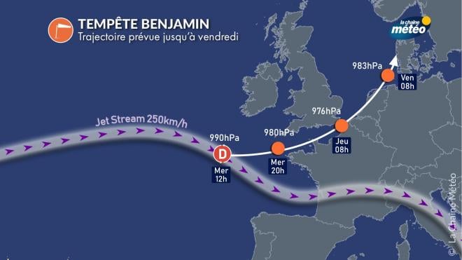
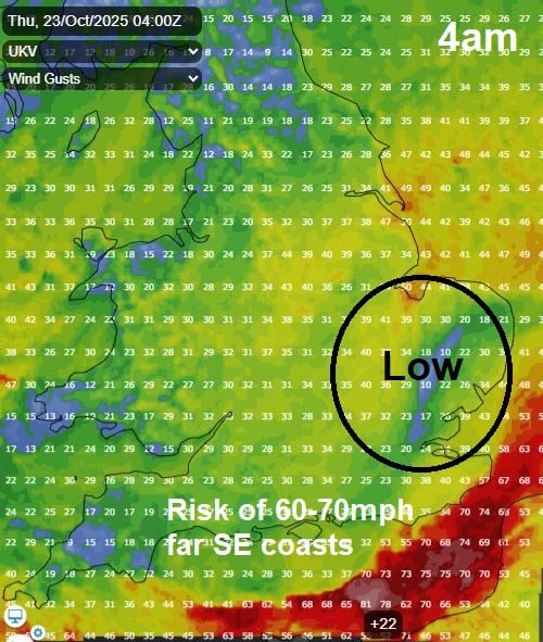
Storm Benjamin has been named by Meteo France, the French meteorological service, for a deepening area of low pressure which is forecast to track through the English Channel early on Thursday - before reaching the southern North Sea in the afternoon.
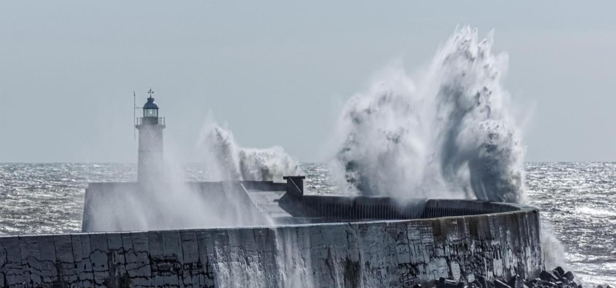
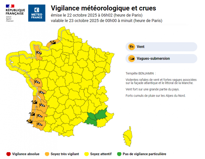
The deepening low looks to bring widespread strong winds on its southern side across France. Strongest gusts are expected on the French Atlantic coast and through the English Channel - where they could reach 60-70mph for a time, though gusts could reach 70-80mph with exposure along the Atlantic coast of western France. Orange warnings have been issued by Meteo France for western departments with Atlantic coastline and also some departments bordering the English Channel.
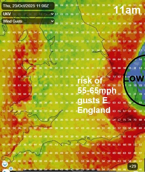
Although the strongest winds from Storm Benjamin look to affect France, there is a risk of gales developing across southern, southwestern and eastern coastal areas of England and coastal west Wales too on Thursday. Strongest winds through the English Channel Thursday morning, then as the low reaches the southern North Sea in the afternoon and winds turn northwesterly or northerly behind the low. Gusts of 60-70mph are forecast by some models through the Dover Straits then across coastal Lincolnshire and East Anglia as winds swing around to the northwest as the deepening low reaches the North Sea. Inland across SE England and East Anglia could see gusts of 45-55mph too. Gusts of 50-60mph also possible further west along southern and southwestern coasts of England along with coastal west Wales, 40-50mph inland across SW England and west Wales.
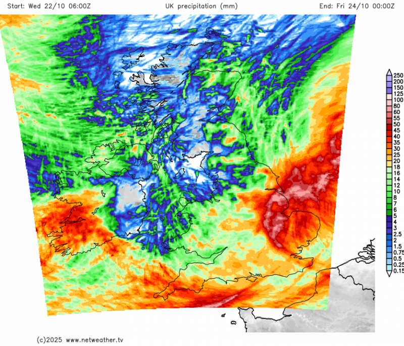
The low pressure system will also bring a spell of heavy rain across south Wales, southern England, the Midlands and East Anglia from later this evening and through Thursday morning before clearing early afternoon, this could bring a risk of localised flooding too.
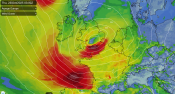
A sharpening upper trough diving southeast from Greenland will engage a baroclinic / frontal zone stretching from the mid-North Atlantic north of the Azores east into France and develop a wave along the zone which then develops into a deepening low which tracks towards the English Channel tonight. Deepening of the low will be enhanced by moving into the developmental left exit region a strengthening jet streak, where winds diverge aloft and converge at the surface, causing falling pressure.
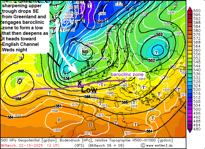
There is still uncertainty about the trajectory and deepening of low, named Storm Benjamin, and therefore about the positioning of strongest winds and rainfall accumulations associated with this low pressure system. 00z GFS deepens the low most out of all the 00z model runs, so the low tracks furthest north, across S England and exiting East Anglia, so brings greater risk of gales inland over these areas. While 00z ECMWF and UKMO track the low further south on an east-northeast trajectory along far south of England to southern North Sea / Low Countries.
Prefer to stick with the Euro model solutions with the English south coast / English Channel then southern North Sea into Netherlands trajectory, rather than the GFS further north across East Anglia solution. 00z ECMWF ensemble mean takes this trajectory.
So late Wednesday night into Thursday morning, a strengthening westerly wind will develop across the Atlantic coasts of France, Cornwall and the English Channel coasts of France and England. Gusts of 60-70mph possible Thursday morning, but locally 70-80mph are expected along western coasts of France and perhaps exposed coasts of northern France along the English Channel. As the low reaches the southern North Sea late Thursday morning, winds turn northwesterly and strengthen across southern England by lunchtime, East Anglia and northern France - with gusts of 60-70mph possible along coastal areas, 45-55mph inland.
So there could be a risk of travel disruption across southern England and East Anglia, as strong winds bring down tree branches or even whole trees, damage power lines and create hazardous driving conditions for high sided vehicles. Also, with spring tides, there is a risk of coastal flooding during high tides.
Loading recent activity...