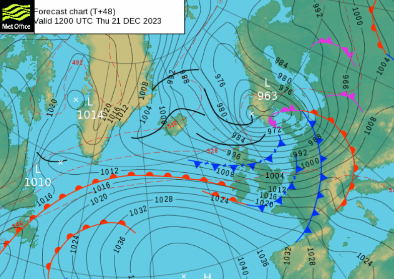
Thursday 21st will be a very windy day with storm force winds possible for the far north of Scotland. Travel disruption is forecast with coastal issues from the low pressure named Pia.
Storm Pia has been named by the Danish Meteorological Institute (DMI) and this low pressure will impact the UK with strong winds and gales. Travel disruption is likely as the Christmas getaway begins. Coastal flooding is also being mentioned with a surge expected down the North Sea. There is already a widespread yellow warning across many parts of the UK (away from the south) for strong winds on Thursday.
DMI "on Thursday evening Denmark's north-west coasts will experience stormy gales with hurricane-force gusts...The strong wind causes elevated water levels along the West Coast"
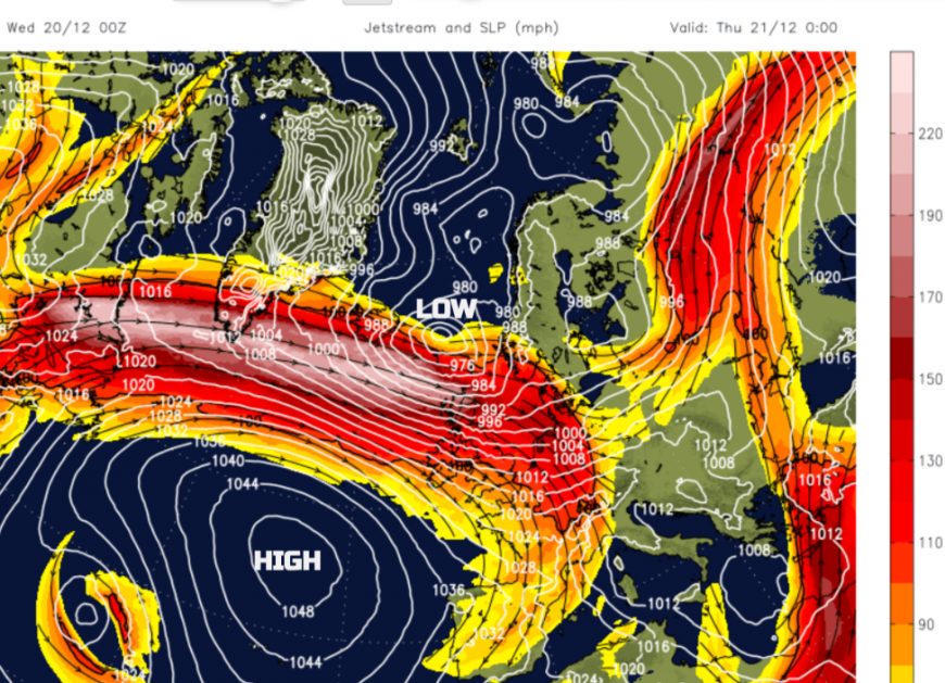
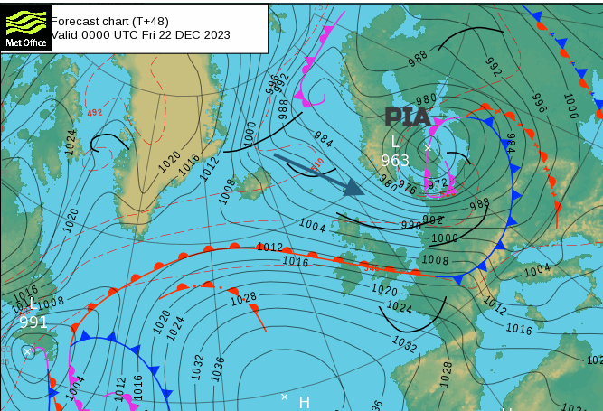
A powerful jet core will extend south of Iceland, stretching from the tip of Greenland to Scotland. The left exit region will develop the low, Storm Pia, near the Faroe Islands which will then head from the Norwegian Sea over southern Norway and Sweden, centred over the Baltic Sea by Friday. The UK will be in between this deepening low pressure and the Azores High which is marked as 1054hPa on the forecast chart for Wednesday. There is quite a gradient between the two and that means strong winds. This large high pressure will slide towards Iberia by the weekend keeping more settled weather for Portugal, Spain and the south of France. It keeps us in an unsettled, windy westerly flow for Christmas so snow is unlikely.
UK Met Office "Strong winds across a large swathe of the country Thursday, causing some travel disruption."
The current fresh westerly flow will strengthen during Wednesday night and then veer to the northwest by Thursday. Stormy weather will set in for the small hours of Thursday with a focus on northern Scotland, particularly the Northern Isles down to Peterhead during the daylight hours of Thursday morning.
This impactful storm has been showing for a while on the pressure charts and with such an important travel period coming up there have been queries about why it wasn’t being named by the UK Met Office, which would have been Storm Gerrit from the Western Naming Group. Pia is from the Northern Naming group.
We waited, wondering, before Frederico was named by Meteo France but did impact already soggy southern Britain in mid-November.
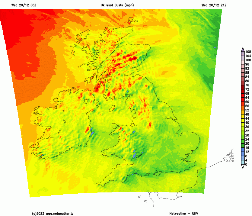
There is a polite dance that goes on behind the scenes allowing the country expecting the most severe impacts to name the storm. And yet , if that country is further east, it won’t feel the impacts until maybe a day later and so there can be an odd wait. Pia is getting a move on and impacting the UK and Denmark on Thursday but this delay doesn't help with the core aim of “Name our Storms' ' which is communicating about severe weather in the UK. As of 10:45am, the UK Met Office hasn’t even mentioned Pia on its social media. The same wind warning Very likely/Low impacts is in place for Shetland and Leicester. Shetland is forecast 57 mph wind with 78mph gust, heavy rain and feels like -1C. Leicester 22mph wind with 43mph wind and cloud. It's happening tonight.
Some ferries to Shetland are leaving early today or are cancelled and for Thursday, North Link Ferries has stated “Thursday 21st December All sailings are under review with high probability of cancellation, updates to follow tomorrow as forecasts are updated. “
For the Western Isles, it is hard to say what is weather-related and what is ongoing other stuff but there will be disruption to the service in the run-up to Christmas. On the trains, the East Coast mainline has seen issues recently with damage to the overhead wires so a bout of high winds won’t be ideal just before all the Christmas travel. There are planned engineering works as usual and early close-downs of some stations including London Kings Cross and Paddington.
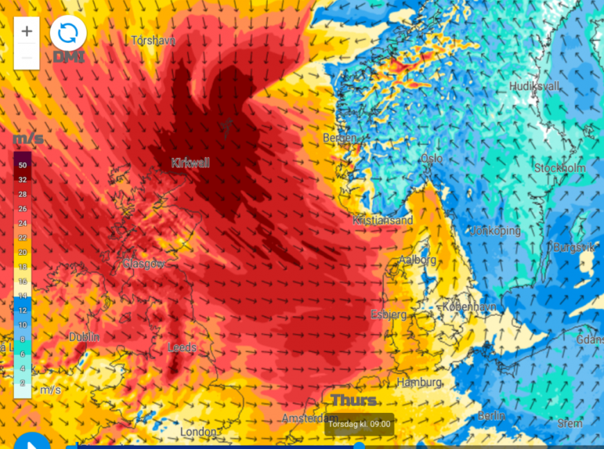 Wind gusts from DMI in m/s (32m/s = 71mph 26m/s = 58mph)
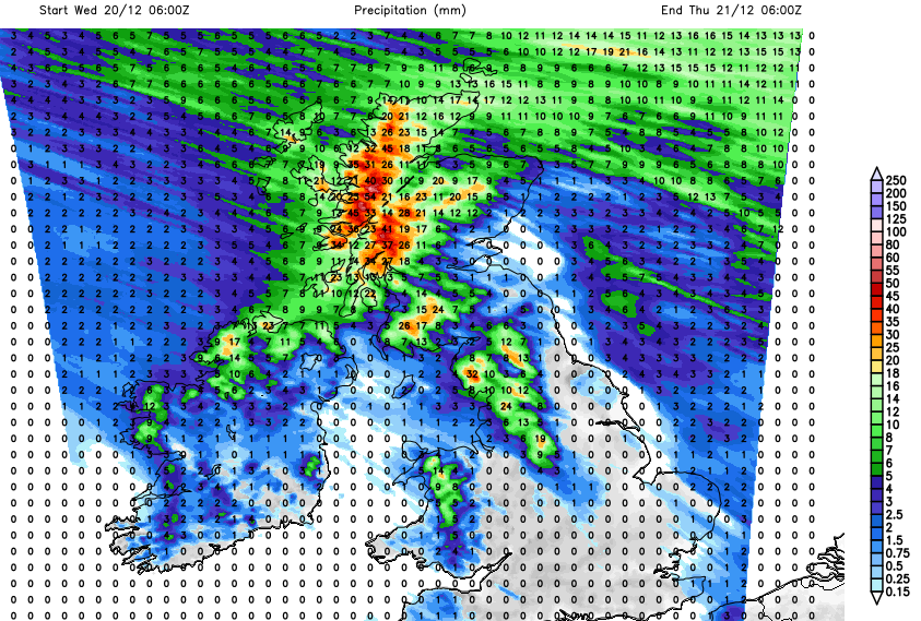
There will be more frontal rain, with the heaviest spell during Wednesday night for Highland Scotland as warm fronts move by which will heighten the risk of flooding and landslides after recent heavy rains. Then as Pia moves over southern Norway, the cold front whizzes over the UK and heavy showers develop with hail and mountain snow. Shetland will see snow showers too. These showers will be over Scotland before dawn but the brighter unstable conditions will reach down through Northern Ireland and Britain on Thursday. SW Britain will keep more cloud. The day starts off mild in the warm sector air but it will feel colder from the north even with the winter sunshine. Worth staying out of the raw wind.
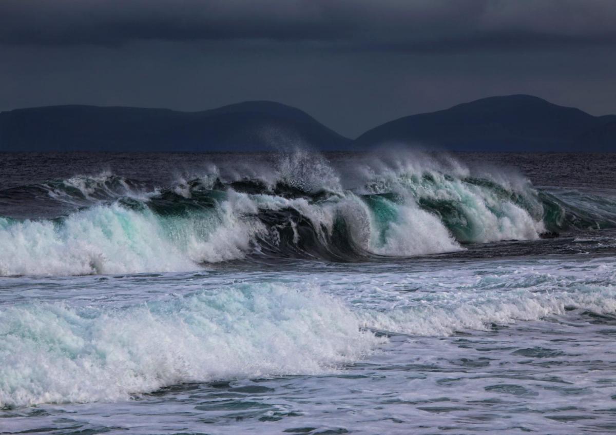
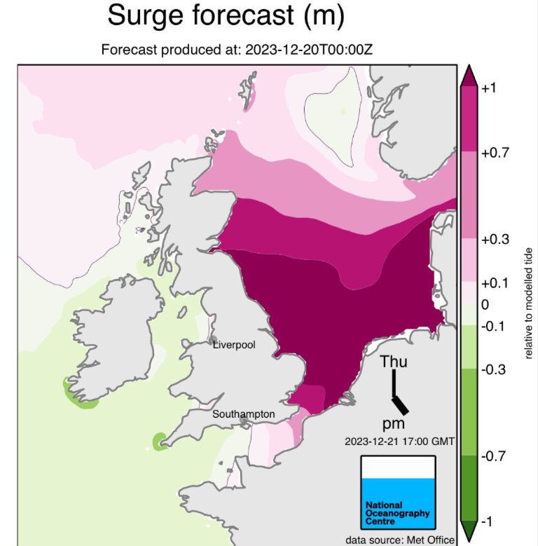
There are also concerns about coastal flooding with a surge down the North Sea. The gradually shallowing basin of the North Sea is vulnerable to low pressures from certain directions. A push of water can be created and if it coincides with spring tides or existing saturated ground, there can be significant issues.
SEPA mentions “Strong winds might result in isolated spray and waves affecting exposed coastal communities on Thursday.” for Scotland.
The Environment Agency in England “Local coastal/tidal and river flooding is possible in parts of the East of England from later Thursday until Saturday. Properties may flood and there may be travel disruption.” There is a Medium risk highlighted for eastern Norfolk on Thursday “It’s likely that overflowing rivers and high tides or large waves will cause properties and roads to flood.”
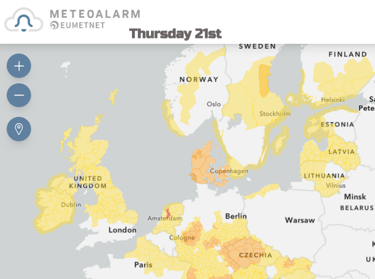
There are wind and flood warnings for the Netherlands. Denmark has amber wind and coastal surge warnings. Norway has wind and snow warnings, and Sweden also has gale warnings.
The Inshore waters for Orkney across to the tip of Aberdeenshire mention “ increasing gale 8 to storm 10 later… high or very high (sea state)”. The Shetland area “veering westerly or northwesterly 7 to severe gale 9, occasionally storm 10 later in southwest”. This will be a wild event in the far north.
As westerly gales hit western Scotland tonight and the winds could reach storm force overnight in the far north it will be windy everywhere for Thursday morning. Over high ground, there will be gusts over 70mph including Pennine routes, over the Cumbrian Fells and the Peak District with sudden lee gusts for northeast England which could affect high-sided vehicles. Do take care, expect delays and maybe adapt plans if possible.
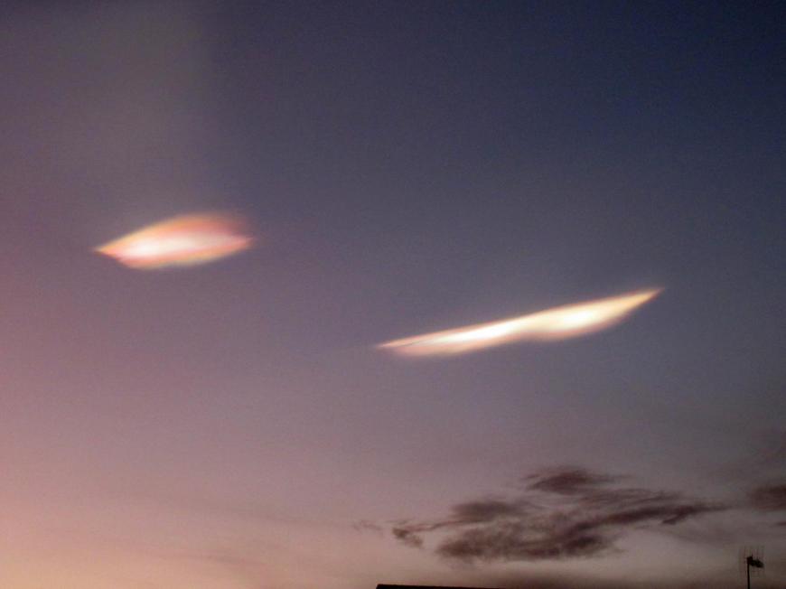
Nacreous Clouds
Under the clear evening skies of central Scotland, there was excitement for cloud spotters on Tuesday. Nacreous clouds were seen as the sun set around 4pm. These rare, very high clouds were seen back in dramatic style back in 2016. Yesterday’s show was a subtle duo but still looked mysterious and eerie. More usual clouds were darkening as the sunset but these two remained lit by the incoming sun’s rays as they form so high up, within the Stratosphere. There is very cold air above the UK at the moment and large-scale storms can help disturb the atmosphere enough to form these clouds.
More about Nacreous clouds from 2018
Storm Pia discussion
Name our storms 2023
Loading recent activity...