A brief ridge of high pressure towards the east will bring a respite from recent wet weather and it may stay mostly dry across eastern England until the middle of next week, but turning unsettled and windy in the west from Sunday.
Much of the UK will enjoy a brief lull today and tomorrow in the unsettled weather that started back in late August, with warmer, drier, sunnier and less windy weather. This is thanks to a ridge of high pressure building towards the east and low pressure stalling out west pulling up a warmer southerly flow over the weekend.
Some very warm air will briefly flirt with eastern England on Sunday, as winds turn southerly, with temperatures reaching the mid-20s
There will be more in the way of cloud and a few scattered light showers in the far west on Saturday, but most will stay dry, best of the sunshine and highest temperatures towards the east - reaching 20-23C.
It looks to remain mostly dry and increasingly warm this weekend across eastern England, bar the odd shower on Sunday. However, it’s all change again across the west initially from Sunday, as an upper trough amplifies to the west of the British Isles, while an area of low pressure at the base of the upper trough deepens, as the southerly flow strengthens on the forward side of the upper trough. This deepening low moving north close to the west and northwest of Ireland.
A ridge if high pressure will bring mostly dry and settled conditions on Saturday, however, upper trough arrives to the west from Sunday, bringing unsettled conditions to the west initially, then all parts from the middle of next week
Bands of showery rain look to spread northeast ahead of this low on Sunday, locally heavy with thunder, especially in the west, but some showers also reaching the east for a time too. But it will also turn increasingly windy too, with gales across the island of Ireland, the Irish Sea and the northwest of mainland UK - with winds gusting to 40-50mph.
Despite the windier conditions, especially in the west, it will be rather warm in any sunshine towards the east, thanks to the strong southerly flow, with temperatures reaching 23-25C, UKV even showing 27C across eastern England. Even in the windier west, with any sunshine, temperatures could reach 20-22C.
Very warm or hot across E England on Sunday ...
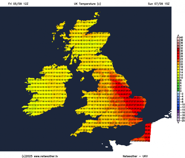
... but also rather windy, with gales in the far west and northwest
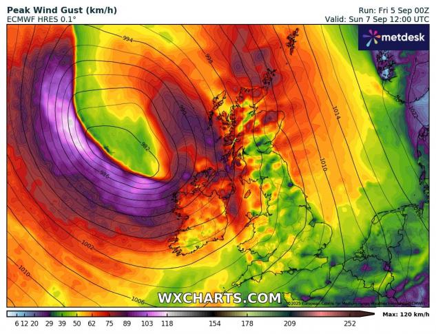
A cold front looks to push east Sunday evening, pushing away the brief visit of very warm air from the south. Staying windy early next week, with a matured fairly deep area of low pressure drifting north between Ireland and Iceland, which will drive further showers, locally heavy and thundery, in across western areas on Monday, but perhaps sunnier, warmer and drier in the east - with temperatures reaching the low 20s here. More like high teens across the west.

A secondary low forming out west over the Atlantic on Monday, to the southwest of the bigger, more mature and deeper low further north towards Iceland, looks to arrive across Ireland or southwest of mainland UK on Tuesday, bringing heavy thundery showers or longer spells of rain from the west, uncertainty how far east these may spread though, eastern areas may stay dry again - with temperatures again reaching the low 20s, cooler in the west.
Showers, perhaps heavy and thundery, could develop more widely on Wednesday, as that secondary low moves northeast, but with some sunny spells too.
Later on Wednesday, the models are indicating a change in wind direction and airmass behind a cold front sweeping east in the evening, with a band of squally rain, from a relative warm and humid southwesterly flow to a cooler westerly flow, driving showers east across most areas on Thursday, though heaviest and most frequent in the west.
Winds perhaps backing more southwesterly again to end next week, as a new area of low pressure arrives to the northwest of Ireland, but remaining unsettled and windy, with further heavy showers or longer spells of rain.
So, in a nut-shell, a drier spell for eastern England through to the middle of next week, though the odd shower can’t be ruled out, very warm or hot on Sunday, before cooling off early next week. Elsewhere, turning more unsettled and windy from Sunday, gales for a time in the far west and northwest, with showers or longer spells of rain. Unsettled for all from the middle of next week..
Loading recent activity...


.jpg?w=767)


.jpg?w=175)