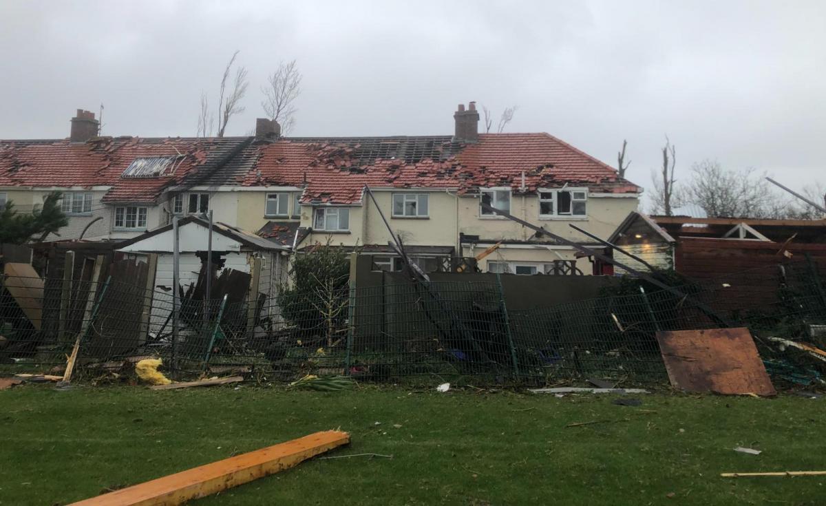
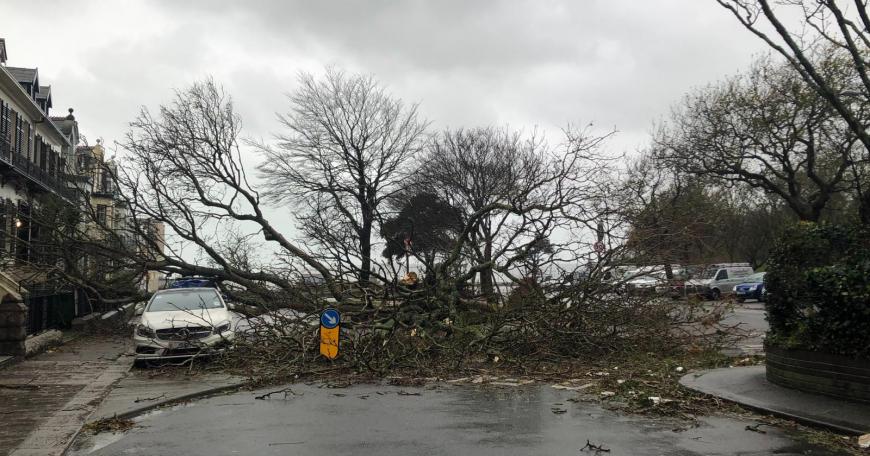
Storm Ciarán brought turmoil to the Channel Islands on Wednesday night. Islanders couldn’t remember a storm like it as roofs were torn off, bricks fell wrecking cars and trees toppled. There was a tornado (confirmed by TORRO) with thunderstorms and large hail, sudden wind gusts recorded over 100mph as mean winds passed Storm Force 10 and briefly reached Hurricane Force 12 (73+mph)
People had to leave their homes as Parish Halls became emergency shelters and even as dawn broke and people could see the overnight damage, the high gusts and wild seas continued on Thursday morning. People were advised to stay at home during the day, with schools closed again on Friday 3rd. The clear-up of trees and debris on roads continues as people try to repair their own homes and businesses.
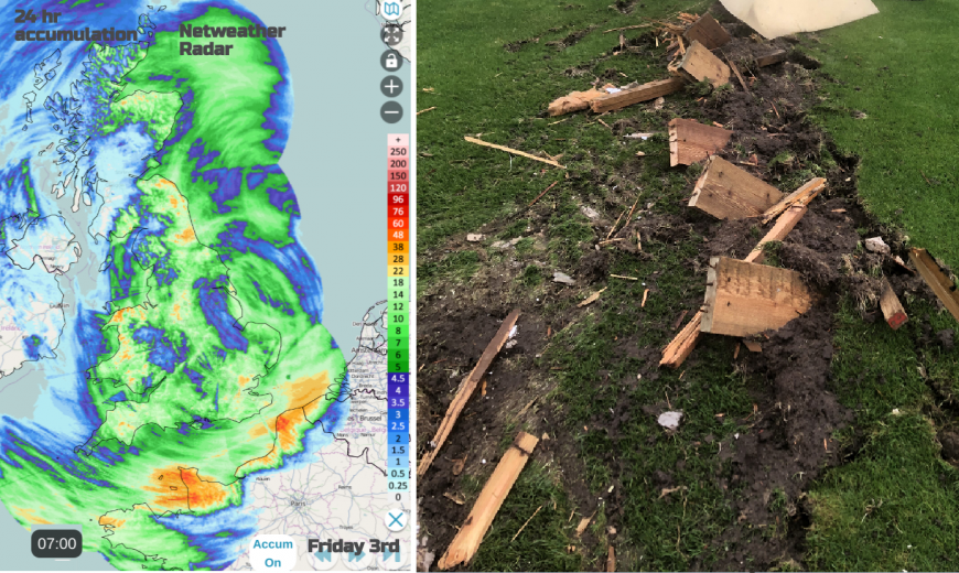
SW England was also hit with large waves, coastal flooding and gales. There was heavy rain for the Channel Islands and southern Britain with surface water flooding and over 50mm falling onto already saturated ground. And more rain for northeast Britain which has not recovered from Storm Babet, the spring tides and for eastern Scotland, the wettest October on record.
Along with the Channel Islands, France was forecast to bear the brunt of Storm Ciarán
Across northern Europe, at least seven people have died, mostly due to falling trees. It has been very wet recently and mild enough that many trees were still in leaf, all adding to their vulnerability in high winds, never mind an exceptional storm.
In the violent winds, there were large waves and a surge along the English Channel. Meteo France said that, although the all-time record of 216km/h gust at Pointe du Raz had not been beaten, there was a gust of 207 km/h here (129mph). It is a highly exposed “ rugged headland” in NW Brittany and all traffic was banned on the roads in that area of Finistère. The Eiffel Tower was closed on Thursday morning with a gust of 87mph. Ile de Batz (an island off Roscoff, Brittany) saw 121mph smashing a record from 1988 and Lannion (Côtes-d'Armor, Brittany) saw 98mph as another location record fell.
By Thursday morning, there were fallen trees, debris littering the streets and countryside and broken power lines. It was reported that 1.2 million homes were without power on Thursday as travel disruption and flooding became more widespread.
Air, rail and ferry services experienced cancellations or long delays across many European countries with weather warnings in Belgium, the Netherlands and Spain from winds and waves. Frontal bands ahead of the low centre brought heavy rain and snow to Northern Italy, Austria and Slovenia with further disruption and flooding.
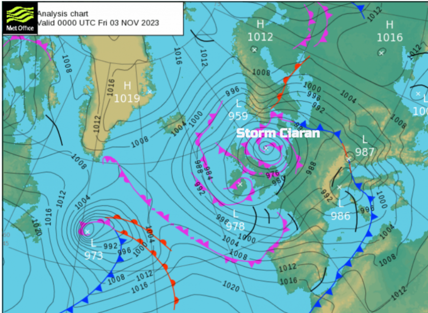
The UK Met Office named Storm Ciarán, but as always in these situations, there will be some areas that are hit hard by severe weather in a named storm and others who might wonder what all the fuss is about. Just because the wild weather wasn’t in your backyard doesn’t mean that the early warnings weren’t valid. This storm was highlighted on Sunday 29th October, a low pressure that hadn’t even formed but was being picked up by all of the forecasting models. The main uncertainty was around the track, a bit further north or south. Looking at the swathe of damage and dangerous conditions through the Channel, imagine that over SE England on Thursday morning.
The forecast develops over time and there is the question (for the Met Offices and for individuals) of how weather warnings are received. Currently, we have this traffic light yellow, amber and red system but almost hidden away in the text is an important matrix which links forecast impacts to likelihood. There is also the problem with people making up nonsense and putting it on social media and then people sharing it, without any checks or critical thinking. But that applies to lots of topics.
Some people get overly worried once a storm is mentioned and others are too blase. Severe weather communications need timely, good quality, consistent, clear information to enable people to make their own informed decisions.
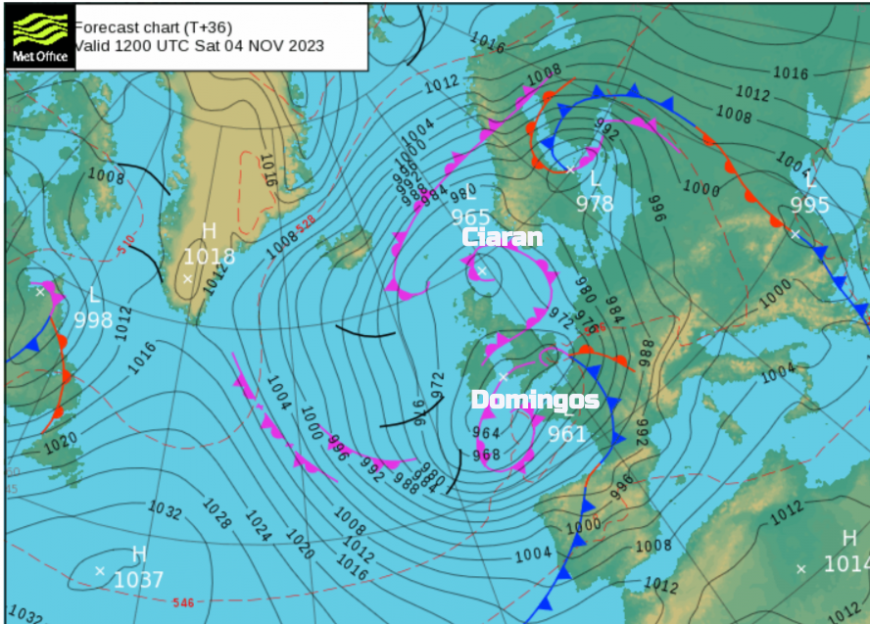
Next up is Domingos, Borrasca Domingos named by the Southwestern group and AEMET, the Spanish Met service. There will be a reluctance to use Storm Domingos too quickly as it will not be the same type of event as Storm Ciarán. The UK Met Office is in the western Group and the next name on our list would be Storm Debi, there is no Storm Debi this week.
Northwestern Europe has been battered by severe weather recently particularly heavy rain and flooding. As another low pressure heads in, there will be wild weather through the Bay of Biscay and further heavy rain from the frontal bands pushing into France, Portugal and Spain then central Europe later on Saturday reaching down to the Mediterranean.
There are amber warnings for wind and coastal flooding in France. Spain still has red marine warnings all along the north coast in the wake of Ciarán.
“Leaving abundant rainfall and especially very intense winds and a significant sea storm, these last two being probably the most significant phenomena.” “ where the significant waves are already exceeding 8 meters in height” AEMET
The frontal bands of Storm Domingos rattle in on Friday night bringing even more rain and strong winds with dangerous coastal conditions.
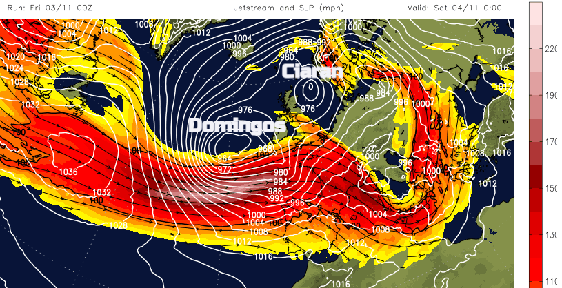
The same large temperature contrast across Northern America still exists and is driving a strong jet across the Atlantic. This is enabling the development of deep low pressures. It’s not a surprise that another significant low is heading towards western Europe, this one looks to dip to 960hPa.
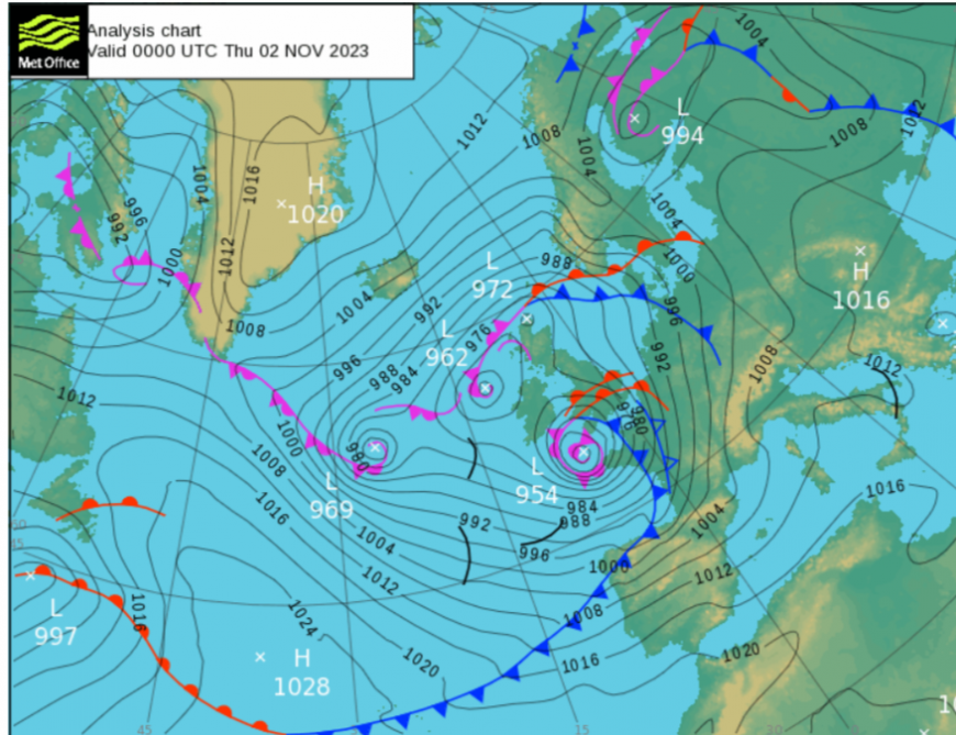
Storm Ciarán set a new record for the lowest mean sea level pressure recorded in England and Wales in November. Plymouth saw 953.3 hPa and St Athan 958.5 hPa. The Met Office said that the previous record in England was 959.7 hPa in 1916 and for Wales 962.7 hPa, set in 2010. The November record for the UK remains unbroken, Scotland in 1877 with a value of 939.7 hPa. The all-time UK record 925.6mb at Ochertyre, near Crieff, Perthshire on the 26th January 1884.
It is worth remembering that many of the warning systems now look at impacts, not just amounts of rainfall or wind strengths. As the ground is already soaked, thinking about how the trees are and the time of day, or part of the week, also recent damage or stress which might be structural or flooding.
Northeastern Scotland has a yellow rain warning for Friday 3rd which includes the ground conditions when considering the likely impacts. Heavy rain associated with Storm Ciarán could bring some disruption to eastern Scotland.
Met Office “Flooding from rivers and surface water is likely in Moray and eastern areas (in particular in East Lothian) on Friday due to heavy rain.” SEPA
Storm Domingos will be nothing like Ciarán for the Channel Islands but there will still be large waves and coastal spray. There is a yellow warning for rain along all counties of southern England.
"Heavy rain or showers falling on saturated ground may cause some disruption, particularly to travel." MO
As the band of heavy frontal rain moves across southern Britain early on Saturday, there will be strong SE veering SW winds for the Isle of Wight into the eastern English Channel. Cornwall could see blustery NW Winds for a time on Friday night and the Channel Islands remain windy but not stormy. There will be a strong southerly, veering SW wind on Saturday.
Photo credits to Stevie Fitz on the Netweather community Forum for Jersey damage pictures
Loading recent activity...