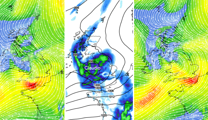
The warm air fades for the start of November, although it won't be cold. There will be some lively and unsettled weather about as we have a deepening area of low pressure in the English Channel for Halloween night, #Claudio, and another larger low midweek.
Monday night’s low pressure has been named by the Southwestern Group which includes MeteoFrance. Claudio will bring westerly gales through the Channel with yellow wind warnings from Dorset to Kent and Amber warnings for NorthWest France with coastal gusts over 80mph forecast. There has been quite a lengthy period of calm weather so this will be a significant change. The Channel Islands inshore waters forecast mentions “increasing 4 to 6 by dusk, veering south-westerly 7 to severe gale 9 by midnight”. The eastern end of the Channel “then increasing severe gale 9 or storm 10 for a time later.”
Met Office warning “While the strongest winds are expected over the Channel Islands and northern France, parts of southern England may well see gales for a time overnight.” There will also be bands of heavy rain across the UK.
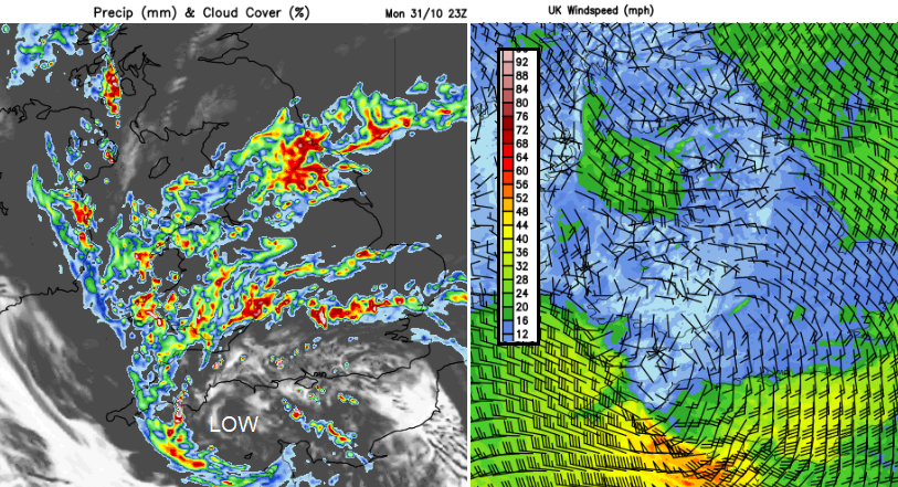
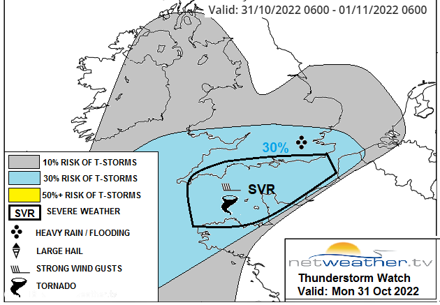
There is also the ongoing risk of thunderstorms. “embedded convection appears likely along the cold front and back-bent occlusion moving N and E across S/SE England, S Midlands and E Anglia later this evening / overnight… some thunderstorms are possible along cold front / back-bent occlusion, perhaps organising into linear clusters, given fairly strong winds aloft, capable of producing locally strong wind gusts and brief intense rain leading to flash-flooding, though lightning not expected to be prolific. “
This little, but spritely, low pressure runs across southern Britain and out over the North Sea by Tuesday morning swinging its fronts up over NE Britain. Sunshine and showers follow for Tuesday but there will be more heavy showers over southern Britain by mid-afternoon. Again, there will be the risk of thunder and hail.
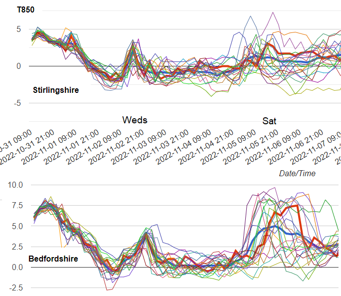
The second half of October has been strangely warm with top temperatures in the high teens even low 20s Celsius/ This week we will lose the strong southerly flow which has brought this very mild air all the way up through western Europe. There are southerly blips along the way but overall, the UK will see a more westerly airflow off the Atlantic and temperatures will fall to where they should be in early November.
So, it won’t be as warm as it has been and there will be bouts of wind and rain as the Jetstream steers low pressures our way. One such low on Wednesday looks to bring very wet and windy weather from the west. In the wind and rain, it will feel cold by day and Tuesday night looks cooler with temperatures more widely down to 3 -6C. Early Friday looks colder in the north but there should be milder air from the south for the weekend.
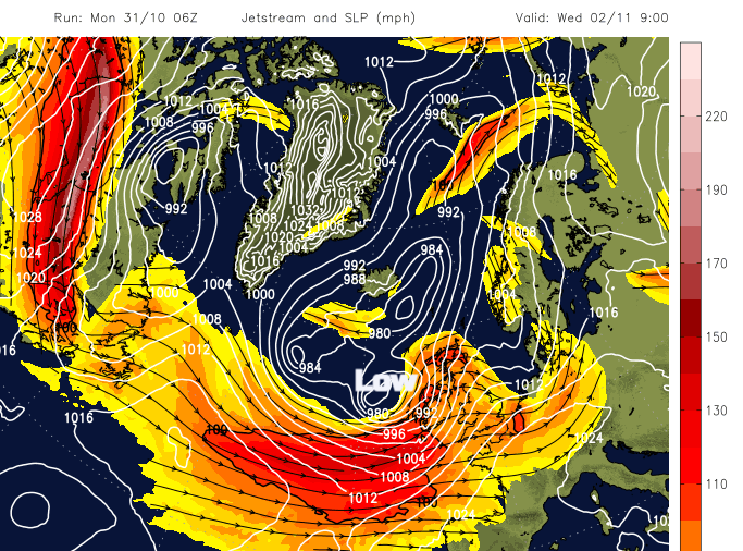
The next developing low pressure appears during Tuesday night out in the Atlantic and throws itself at the UK on Wednesday. Our storm naming group has not had a name yet this season. It would be Antoni if any of the three national Meteorological Offices decide to name it. Currently, the low centre is forecast to skim past NW Scotland and away north-eastwards in the middle of the week and there will be a spell of heavy rain and strong winds. Also, gales for exposed areas, even severe gales are being mentioned.
The high winds and heavy are forecast to affect Northern Ireland on Wednesday morning, the Irish Sea and western Britain by lunchtime, extending over Scotland too. the strong gusty winds will move over northern England, more of mainland Scotland and the Northern Isles by the evening. High winds continue through Wednesday night for the west coast and Central Belt of Scotland, as the wind and frontal rain reaches down to SE England
The low pressure looks to move through fairly quickly which lessens the risk of flooding, but the trailing front seems to hand back over SE England and begin to wave on Thursday’s charts. This would bring a lot of rain. Welcome rain but not all in one go and there could be surface water flooding.
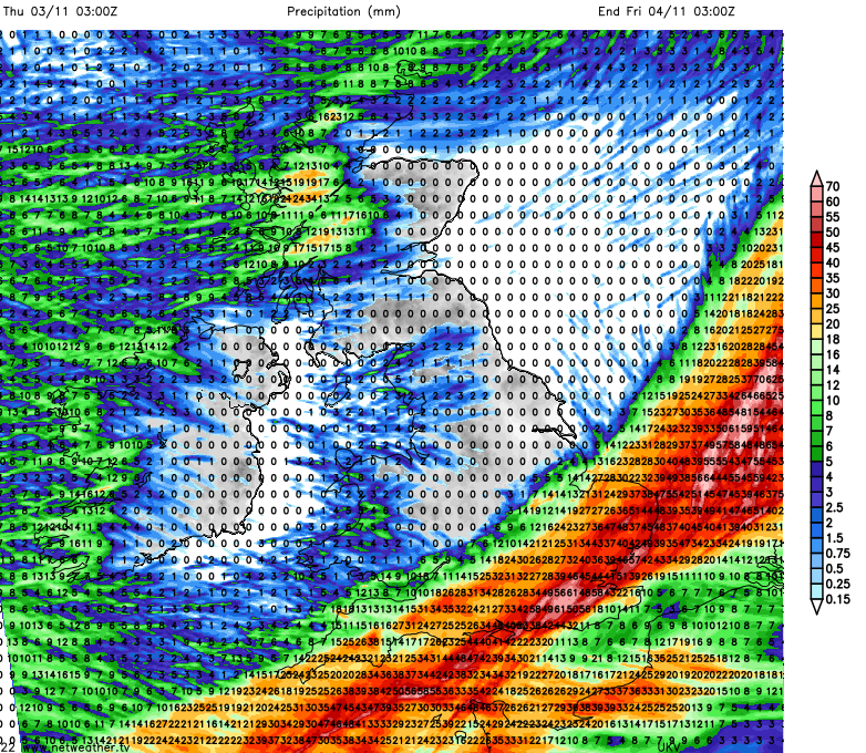
The details of this midweek low will change over the next day or so, but we are in for an unsettled spell with strong winds and widespread, proper rain.
Loading recent activity...