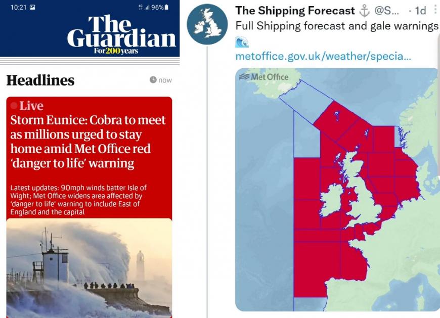
Storm Eunice brought two rare red warnings for southern Britain, February 2022
In a week of three storms, London and SE Britain saw their first red warning for wind since this traffic-light style warning system began. Storm Eunice brought severe gales to the UK, a tidal surge, gusts up to 122mph, driving rain and snow disruption on Friday 18th February 2022. Sadly, four people died in the storm with repairs and recovery being hampered by the arrival of the next storm and then flooding. It wasn’t the most intense storm that the UK has seen but it was certainly significant and damaging with its widespread inland gusts over 70mph. Quite a daytime event
“The most severe and damaging storm to affect England and Wales
since February 2014. A gust of 122mph was recorded at Needles Old Battery, Isle of Wight, setting a new England gust speed record. Winds gusted widely at over 69mph across southern England” Met Office
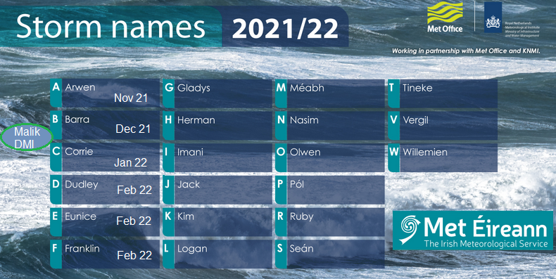
This season’s named started with tree slaying Arwen in November 2021 which hit NE Britain with a red wind warning for the evening of the 26th. Danish Malik was quickly followed by Corrie in January and then a week onslaught of Dudley, Eunice and Franklin. Not ideal for those on February half term.
The disruption and damage from Arwen are still having repercussions. There are still weakened trees and rail networks are perhaps being more cautious in the north, even now months later. These storms bring power or communication cuts and some properties have spent months without proper connections.
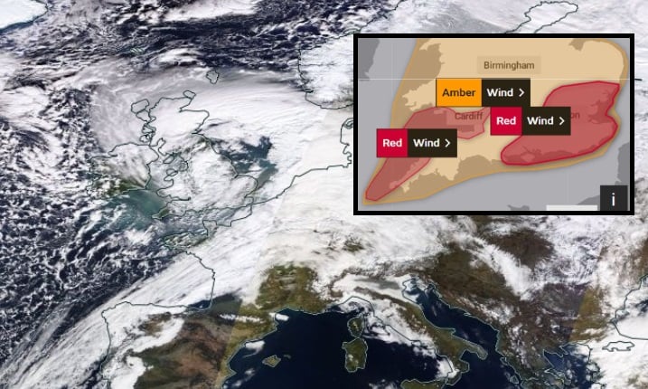
Most of this weather has been affecting ‘the North’ but Storm Eunice was different. At the start of the week the UK Met Office had issued an early ‘heads-up’ yellow warning for strong winds and by Thursday 17th a widespread Amber over Wales and much of England. Then a red warning for the north Cornwall coast, north Devon into the Bristol Channel and the coast of south Wales. There were flooding concerns up to Gloucester with the strength of the winds, the push of extra water ahead of the low pressure adding onto the tide. The warning was for the wind strength, with dangerous conditions forecast and people being advised to stay indoors for Friday morning.
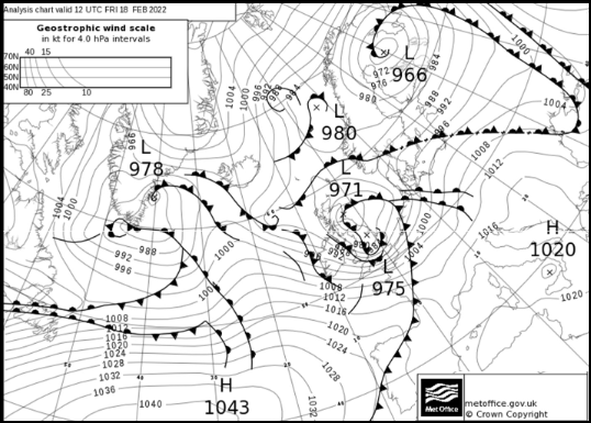
A succession of low pressures isn’t unusual. If the conditions are right for deep lows to develop then why not see more than one. There was a sharp temperature contrast with cold air coming out of North America and the Arctic, a powerful jet core which Eunice engaged with, and this was what was causing the concerns. That this low would undergo explosive cyclogenesis and might produce a ‘sting jet’. This is when violent winds are drawn down from the upper atmosphere and happened in the Great Storm of 1987. The ingredients looked to be in the atmospheric pot and will have added to the headache for Met Office forecasters. Having to decide if SE England and London should get a red warning with all the logistical implications. Forecasting exactly where and when a sting jet would hit well enough to give truly accurate location information is, maybe, still just beyond reach. Forecast modelling improves all the time and this setup only occurs very rarely. For now, we need to read and heed the wording that goes with the warning images.
“The central pressure dropping by approximately 30hPa within 18 hours while the storm developed to the west of Ireland.“ Met Office
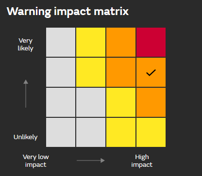
Essentially under a red warning you should get indoors if you can and stay there. The Met Office is saying that there is a high likelihood that severe weather will occur and along with High impacts from the weather conditions. Two parts result in these impact-based warning colours. Both coming together to show a dangerous event. Amber and yellow warnings are also of Severe weather, however there might be less confidence in this happening within the warning area, or the impacts are forecast as medium rather than high.
There are issues with the current warning system but do suggest a better one. It is not just about numerical values, say wind strength reaching gale force or 50mm of rain etc. It’s about how widespread serious impacts could be. It is about time of day, so Monday morning rush compared to Sunday midnight, seasonal conditions and travel. This was the start of February half term. It’s about population density and recent weather/surface conditions, what the area can take.
The red warning for SW Britain that was issued the day before meant that people could make solid decisions. Bus services were cancelled as were bin collections, bridges closed. Councils said that schools would be shut the next day and libraries. People went to bed with a clear idea for Friday. There is chat that issuing an amber warning lessens a yellow warning in people’s eyes and that a red can do the same. The whole thing is open to interpretation. You can read the Met Office Guide of what weather is expected and what the 3 levels are supposed to represent but not sure how many will on the day.
Red warnings are very rare. Under one of these people should know that the weather is going to be foul and dangerous. It means that weather conditions with High Impacts are Very Likely in that location. How people then chose to respond may vary, but this process is about giving information so that decisions can be made, by you and organisations.
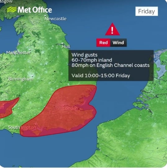
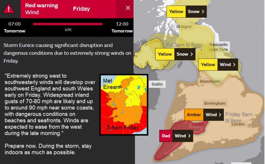
By Friday morning a red warning had appeared for London and SE England starting at 10am. The worst of the winds would be spreading across southern Britain, so the day started off windy but not stormy in the capital, did this affect people’s choices first thing? For SW Britain it was wild from dawn. However, the whole event had been very well highlighted with the ongoing amber warning and strong wording. Maybe making a personal decision under an amber warning is harder than a red?
In the end, there were fences and trees down, damage to buildings with tiles off, roofs ripped. Over a million homes lost power. Hopefully, the warnings helped people prepare for this, as some power cuts lasted days, hampered by Storm Franklin coming along so soon afterwards.
There was major travel disruption with overturned lorries on major routes, most of the rail services stopped and flights were cancelled. Major bridges closed, scaffolding was wrecked. The O2 Millennium Dome roof was ripped and a church spire in Somerset blew off. Any train which did still manage to travel south of York had to creep along, taking double the time due to speed restrictions with worries of trees on the line or debris. London Fire Brigade declared a major incident due to the volume of 999 calls being made because of Storm Eunice as did Ambulance Services. Big Jet Tv became the online sensation of the day, filming planes trying to land in the storm with excited commentary.
The very exposed coastal site at Old Battery Needles lighthouse on the Isle of Wight recorded a gust of 122mph, the highest ever for England, so a new record from Eunice. For those who watched and experienced the storm, the power and wild gusts were certainly something.
There was also snow, which moved over inland hills of northern England before dawn but set in for the northern half of mainland Scotland during Friday. Schools were closed, a few lorries were stranded as conditions on the roads worsened, including the higher parts of the M8 between Glasgow and Edinburgh
There had been coastal flood warnings due to a combination of high tides, large waves and a tidal push ahead of Eunice but the rivers were next. The cumulative effect of the rain from the three storms led to flooding for northern England and the Midlands particularly across to the River Severn after Storm Franklin. It has been quite a month.
More discussion about this season's storms in the Netweather community forum
Loading recent activity...