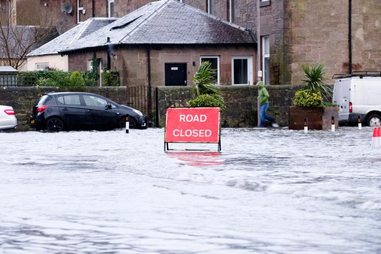
Storm Desmond, the 4th storm of the season named by the Met Office and Met Eireann, brought extreme rainfall and storm force winds to parts of NW Britain on Saturday, with Cumbria, the Scottish Borders, north Wales and N. Ireland particularly badly hit. Parts of the Lake District in Cumbria saw 24 hour rainfall totals of 180-200mm, with a few rain gauges reported to have recorded in excess of 300mm. The December average rainfall for Cumbria is 146.1mm.
Extreme rainfall events becoming increasingly common in NW Britain?
Two previous extreme rainfall events have been seen in Cumbria in just the last 11 years. On one day back in January 2005 a 24 hour rainfall total of 180.4 mm was recorded at Rydal Hall, Cumbria, which was estimated as likely to occur less often than once in 200 years. Only 4 years later, in 2009 Seathwaite in Cumbria had 316 mm of rain in the 24-hours from midnight to midnight on 19th November - a UK record for any 24 hour period. The worst affected town was Cockermouth where the depth of floodwaters reached 2.5 m. But parts of Dumfries and Galloway, The Scottish Borders and north Wales were also badly affected by flooding
Yesterday, the village of Shap in Cumbria saw 201.0mm in the 24 hours between 00z Saturday and 00z Sunday, topping the 'once in 200 year' event in 2005, with a 48 hour total at Shap of 262.6mm. Provisional figures from a rain gauge at Honister Pass in the Lake District showed 352mm of rain had fallen in 24 hours, which beats the previous 24 hour record set in Seathwaite, mentioned above, back in November 2009.
Table 1. Rainfall totals in November 2009 (figures courtesy of the Met Office)
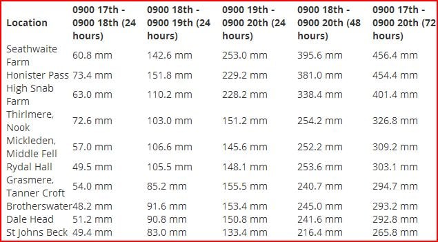
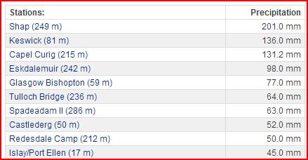
Table 2. Top ten UK Rainfall totals for a 24 hour period of 00z Sat 5th Dec 2015 to 00z Sun 6th Dec 2015 (Weatheronline)
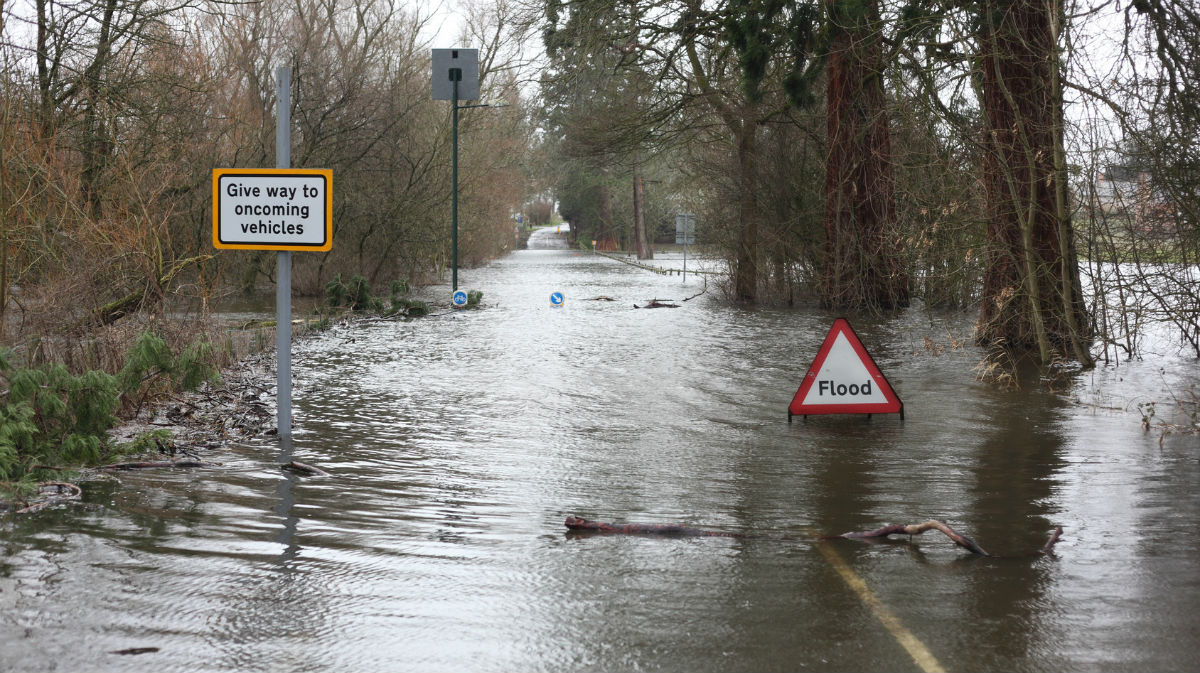
The flooding of Carlisle on the 7th January 2005 was the result of prolonged rainfall over nearby Lake District and Pennines draining into the River Eden which flows through the city. As a result, £38 million was spent by the Government on flood defences, which completed in 2010. However, the defences were over-topped last night causing flooding again in the centre of the city, with some locals saying the flooding was worse than back in 2005. The new defences did, however, give the authorities more time to evacuate people. Most of the rivers and streams draining through the Lake District communities passed their peak levels overnight. However, as the River Eden is a longer river with Carlisle in the lower reaches, the peak river level was expected to reach the city later during Sunday morning.
What’s caused the extreme rainfall?
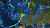
Several atmospheric factors came together to bring the extreme rainfall to NW Britain on Saturday. The upper level flow aligned with the trailing frontal system attached to Storm Desmond that was moving NE across southern Scotland, this meant the frontal zone stalled across Scotland, rather than pushing away. The strong southwesterly flow across northern Britain on Saturday was part of an ‘atmospheric river’ of very moist air that can be seen on the precipitable water (PWAT) chart below feeding right across the Atlantic all the way from the Caribbean and Florida. Such tropical maritime flows are notorious for producing extreme rainfall across higher ground of northwest Britain, as forcing from a stalled frontal zone combines with orographic uplift of mountains of North Wales, Cumbria and western Scotland.
Figure 1. Precipitable Water (PWAT) values for noon Saturday show the 'atmospheric conveyor' all the way from the Caribbean (image courtesy of Weatherbell.com)
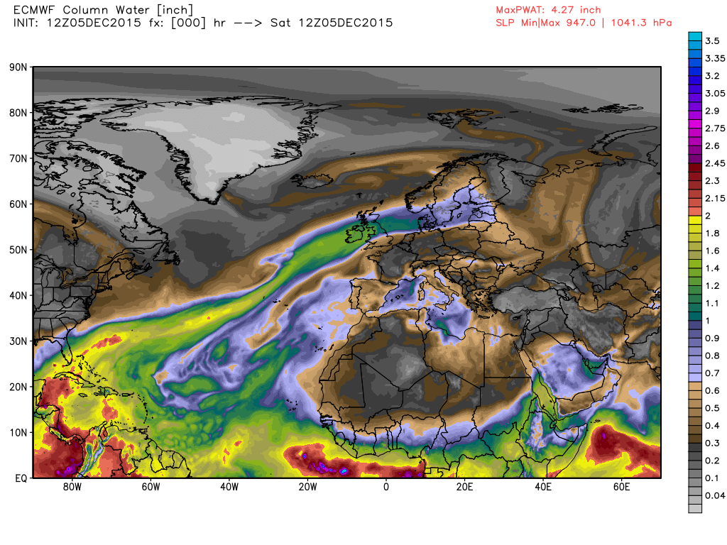
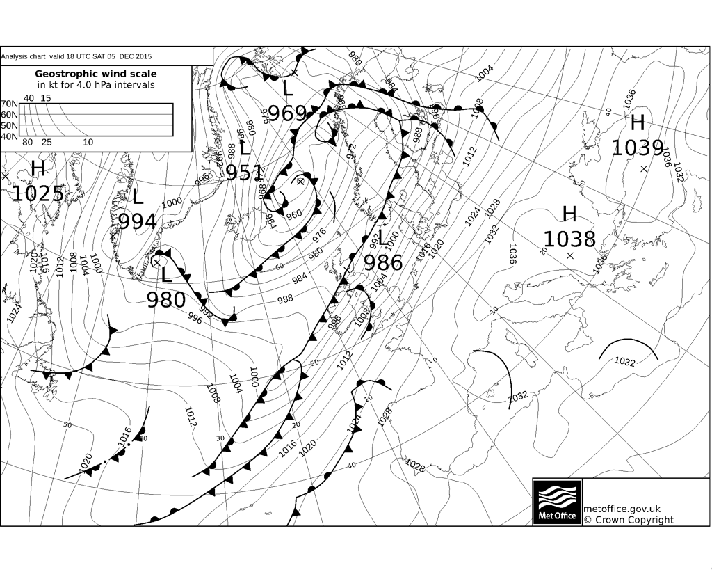
Figure 2. T+00 UK Met Office fax chart for 18z Saturday 5th Dec shows the stalled frontal zone marking the northern extent of the atmospheric river.
Fortunately the upper flow backed northwesterly early Sunday, as an upper trough pushing down changed the upper wind direction, so the stalled front on Saturday has moved southeast today away from the flood affected areas – which have seen a drier day with some sunshine. The front has weakened as it heads southeast across England and Wales, so no flood worries further south.
Will it happen again?
What used to be once in 100 year or even 200 year flooding events appear to become increasingly and worryingly common, as this current event in Cumbria illustrates, 6 years since the last record breaking rainfall event in a similar area. Whether this is a direct cause of global warming, natural or man-made, is open for debate but not for discussion in this blog. But it does seem flooding is becoming a more frequent visitor to our country and nowhere seems immune, as the winter floods along the Thames a few years ago showed.
More rain on the way this coming week
Looking ahead into the new week, the weather stays unsettled with low pressure remaining close by to the west or northwest, bringing more fronts with their rainfall across the UK. We are unlikely to see extreme rainfall return to NW Britain, though there will be further rain which is not a help to reduce the high river levels.
Rain returns from the southwest Sunday evening as the next deepening low pressure system spins up to the west of Ireland. This rain will push northeast across many parts Sunday night, then continues to spread northeast across Scotland on Monday, with another band of rain spreading across EIRE and Northern Ireland in the afternoon. The rain generally lighter and more patchy for the flood-hit northwest than Saturday, though unwelcome all the same! However, the band of rain across the far west will continue east across most parts Monday night, perhaps bringing another 30-40mm across higher ground of the NW before it clears.
By Wednesday, high pressure will try to build across the south bringing drier conditions to southern and central parts, however, rain and strong winds will return to Scotland, EIRE, N. Ireland and perhaps parts of NW England. This rain spreading southeast across much of England and Wales on Thursday, followed by showery conditions across NW Britain to end the week, though hopefully the showers will be fewest across the flood hit areas.
Loading recent activity...