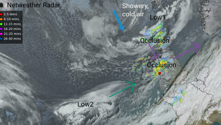
It has been a very windy night in Scotland with a gust of wind of 83mph in the Western Isles and over 100mph gusts for the mountain tops. This is thanks to a large low pressure (Low1) which is slowly moving between Iceland and northern Scotland on its way to Norway. What is causing more of a headache for Saturday’s forecast is a developing low pressure (Low2) which will move over England and Wales.
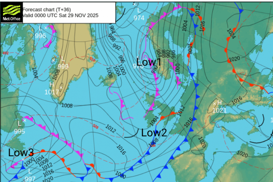
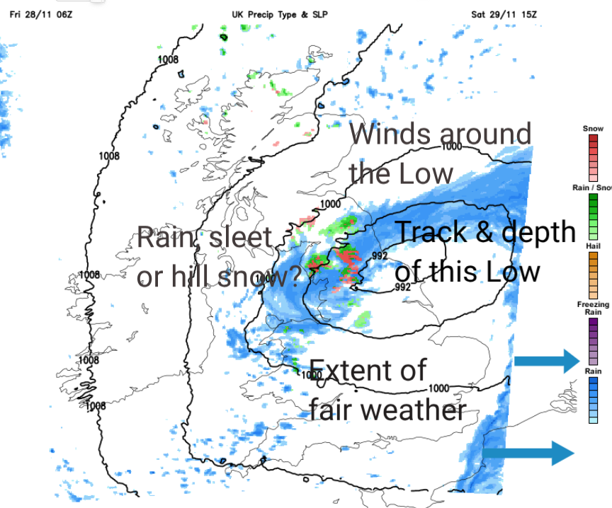
One option brings an area of rain over southern Britain on Saturday leaving northern Britain, and Northern Ireland, in fair but cold conditions with showers from the north. Another takes the low further north with the main frontal rain over Wales (with mountain snow) into northern England as the cold front drags over southern Britain with a narrower band of rain. As an occlusion moves down from the north, this merges with the more active warm front and could produce some wet snow. It depends how the low pressure depends. There are variations from almost just a wave moving over England and Wales with a separate occulsion from the north to a deepening low merging with the occlusion and heavier precipitation over a central swathe of the UK.
The low will rotate away over the North Sea later on Saturday but again there is uncertainty about how it will clip perhaps SE Scotland and affect NE England/Pennines in the evening, with cold air close by. There will be a return to cold Arctic air during the weekend. On Saturday into Scotland and Northern Ireland and turning colder everywhere on Saturday night with a frost. However, some areas will stay windy as the low pulls away over the North Sea.
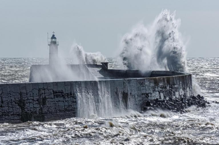
The concerns in all of this are heavy rainfall, strong winds, possible wintry precipitation including hill snow in the north and ice by early Sunday. It’s a busy time of year with people out and about shopping, visiting or attending social events.
London has a fine and mild day for Black Friday shoppers (who are leaving their homes rather than staying online). It will brighten up as temperatures reach 13C and will stay dry for SE England. At the other end of the country, Aberdeen should reach 8C but will feel more like 4C in the strong, gusty winds as bands of rain from the west interrupt the fair weather. Manchester will feel cold in any blustery rain which passes by, but there should be fine weather later but it will only feel like 4C this evening.
The winds will ease in the north of Scotland this evening as the cold Arctic air arrives when the winds veer to the NW. It will be windy on Friday evening for Northern Ireland, the Central Belt, the Irish Sea and across northern England with tricky conditions for high-level routes.
These winds will ease overnight as a southwesterly strengthens for Cornwall in the small hours as Low 2 arrives.
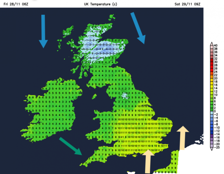
The picture for the start of Saturday is cold air in the north with light winds, frost, clear skies for some and wintry showers for the far north of Scotland. Over England and Wales, there should be more cloud, frontal rain and a region of mild air with a southerly flow. How it feels will depend on the wind and the rain but temperatures could still be in double figures for the start of the weekend.
The problem remains with the track of this low and where will see the heaviest rain and where might escape. Also, how far north will it reach and where will then see hill snow in heavy precipitation or along the northern edge of this band. Watching the Netweather Radar on Saturday morning will give an update but don’t cling to timings on weather apps, as this is a situation when the focus on the heavy rain might shift away from you or right on top.
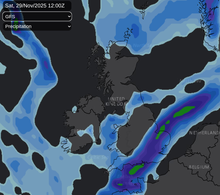
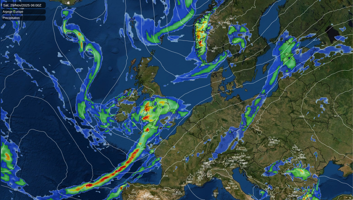
The GFS model (which had shown a very northerly track earlier this week) is now one of the most southeasterly solutions for Saturday. It shows the main focus of the frontal rain heading over to The Wash, the occlusion across central Britain and showers from the far north.
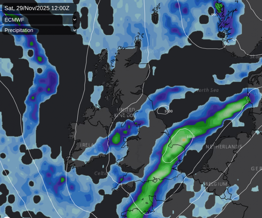
The ECM model is very similar, with the frontal rain pivoting near The Wash as the band swings across southern England, to the Home Counties in the afternoon.
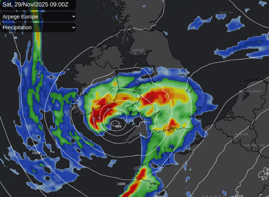
The Arpege model shows a very wet start for Wales and Cornwall with the heaviest rain pushing up through the Midlands into northern England, with the likelihood of hill snow but a narrower band moving east over southern counties of England. This would leave some fair weather for southern Britain on Saturday.
The UKV Model takes the heaviest rain over Merseyside and north Wales early on Saturday, into northern England and across a central swathe of the UK. The cold front looks quite lively as it moves eastwards over southern Britain. Line convection is showing in the morning as it reaches SE England and East Anglia around lunchtime. Behind this, it is leaving more fair weather for middle/southern England but grim conditions for northern England, even into southern Scotland as it clears Northern Ireland and north Wales.
Later in the day, the low will rotate away from either East Anglia, in the southern solutions, followed by the occlusion, or take its time from NE England/SE Scotland with a higher risk of wintry precipitation. All the time, the cold Arctic air will be spreading southwards with strong, gusty winds wrapped around the exiting low. This will add to how chilly it will feel on Saturday evening. For the far nort,h there will be a mix of rain, sleet, hail and snow in the showery flow from the Arctic.
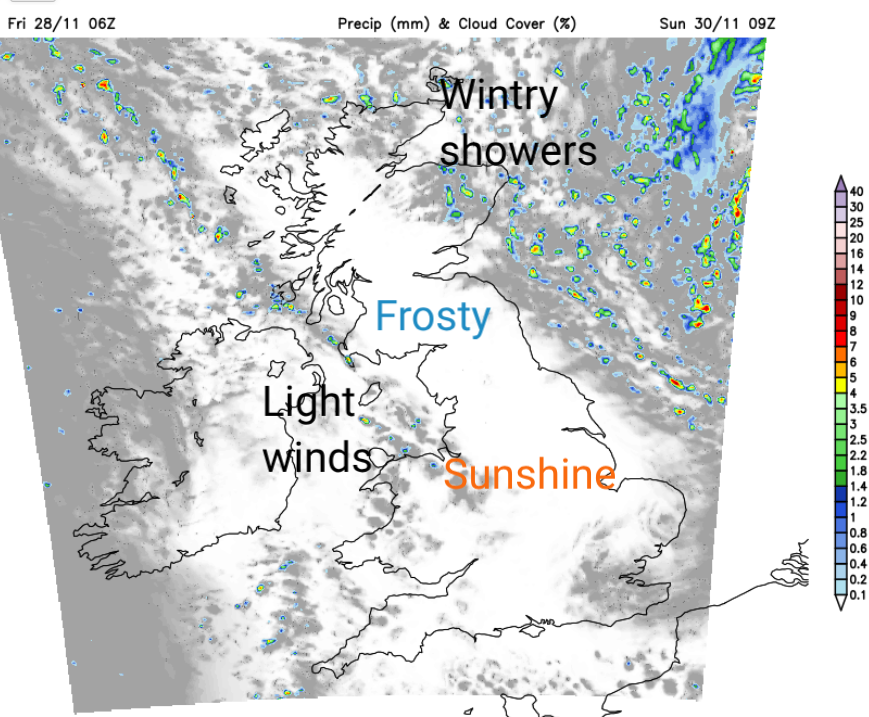
A cold start on Sunday, but a much better day overall as the winds will be light, there will be sunshine with just a few wintry showers for Grampian.
Met Office warnings for heavy rain and the risk of flooding are appearing for Saturday and the start of the new working week but as the winds back to a northerly on Saturday afternoon, this could need watching. It will depend on where the low pressure ends up but the UKV has a signal for a nasty tuck of gales into County Durham, so do keep an eye on the forecast if you are travelling on Saturday, especially along the A1 or Pennine routes.
Loading recent activity...