We are heading into December, which leads to the usual questions about how the winter of 2025/26 is going to pan out.
Until the exceptionally cold December of 2010, which was the coldest since 1890 in the Central England Temperature series, but the coldest for much longer than that in some areas further north, December was a month that hadn't showed much warming since reliable instrumental records began. Averaged over the past four centuries, January has most often been the coldest month of the year, with February second and December a close third behind February.
But in the 1990s and 2000s, January and February were generally warmer than earlier in the 20th century, while December ran counter to the warming trend and was often the coldest month of the year. There was a run of years with cold and sometimes snowy weather recurring especially between Christmas and New Year, with widespread white Christmasses in 1995, 2009 and 2010, and some areas also saw a white Christmas in 1993, 1996, 1999 and/or 2004.
Since 2010, December has joined the other months of the year in running about 1C warmer than was typical prior to the 1990s. However, there have been some wintry spells in recent Decembers. December 2024 was a consistently mild month which was largely frost and snow free in most lowland areas, but December 2023 had a wintry spell at the start with widespread snow on the 3rd, and December 2022 had a prolonged cold spell up to the 18th with sharp night frosts and snow for some.
There was a long run of generally sunny Decembers that also started in the 1990s and continued until around 2014, but since then the pendulum has swung towards dull Decembers. The Decembers of 2020, 2021, 2023 and 2024 all had well below average sunshine in at least some regions of the country, though December 2022 was generally sunnier than average thanks to some clear sunny spells during the cold spell.
At the moment, the first half of December looks set to be dominated by mild and changeable weather, with low pressure especially centred to the west of Britain, bringing frequent southerly winds. There is a growing signal for a Scandinavian blocking high to feature, sending low pressure systems to the south as they head into Europe off the North Atlantic. However, at present it doesn't look likely to be placed in a way that will be conducive to bringing cold air masses from Russia and the Arctic towards the British Isles.
Some model runs are seeing Britain develop an easterly airflow, but typically a south-easterly type with the air masses coming from south-eastern Europe, which is looking set to remain mild for the time of year. Generally the blocking high looks set to be centred especially over eastern Scandinavia and western Russia, which is too far east to make it the dominant factor in Britain's weather - typically for a cold easterly type to develop you need the Scandinavian high to start ridging westwards towards Greenland and Iceland.
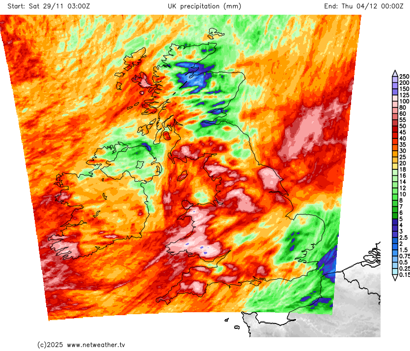
The first half of December has potential to be very wet in western Britain, where rain bearing frontal systems have potential to become slow moving at times as they push against the Scandinavian blocking high. It also has potential to be another dull first half of December. Some mild and changeable Decembers come out with above average sunshine, especially in eastern Britain, but these are typically the ones where frontal systems move freely from west to east and are often separated by periods of bright and showery weather with polar maritime air masses. The first half of December 2025 looks more likely to be dominated by slow moving fronts and spells of rather grey and at times misty or foggy weather in between.
Rainfall totals across the next 5 days

There is potential for things to change into the second half of December, with the Scandinavian high perhaps strengthening and bringing more settled and colder weather to the British Isles. The ECMWF 42-day forecast at the time of writing has the Scandinavian high potentially extending westwards to the north of Britain, bringing the possibility of something substantially colder heading in from the east.
These 42-day forecasts have not always been reliable, and this is a fair way out and subject to change. But with some blocking anticyclones looking set to be in place to the north of Britain towards mid-December, especially around Scandinavia, some of the building blocks will be in place to increase the chances of something colder heading in at some point in the second half of December.
Loading recent activity...