The weather will be fairly slow-moving over the next few days, with areas of cloud with showers or outbreaks of rain spreading north but also some brighter spells, temperatures a little above average in the southerly flow.
From Tuesday, we start to see more energy injected into the weather off the Atlantic, as we see the arrival of a strong jet streak from the west into western Europe. This will bring in areas of low pressure in close to the southwest, bringing windier and more changeable conditions for the rest of the week, with spells of rain or showers spreading north across the UK at times, but also some drier and brighter interludes. Temperatures generally above average, perhaps reaching double figures in the south.
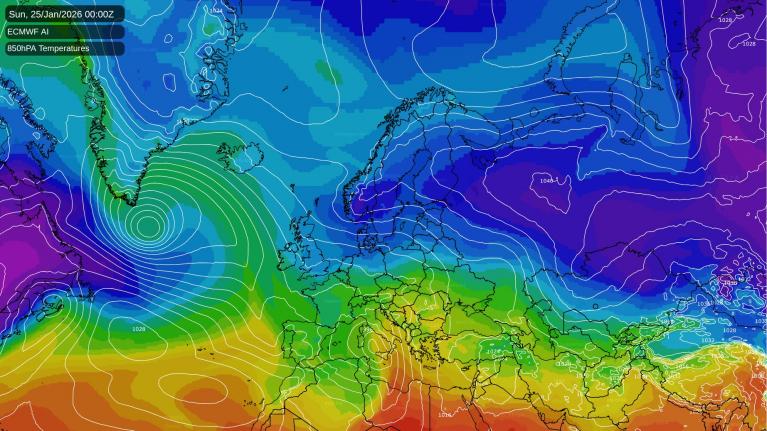
Strong jet stream arrives over W Europe, bringing low pressure close to the UK and unsettled conditions through this coming week
However, from the weekend, we will start to see a battle develop right over the UK between two opposing weather regimes. On one side of the battleline will be Atlantic low pressure systems trying to assert control over our weather, bringing relatively mild, moist air and unsettled conditions.
Deep cold air lurking over NE Europe may spread to the UK later next weekend
But at the same time, high pressure building to the north and northeast will encourage colder and more stable air to edge into northern parts of the UK initially and perhaps all parts the following week. This colder airmass will be sourced from a very cold Russia, though likely not as cold as there by the time it reaches the UK. But could be cold enough to bring snow even to lower levels, but this depends how close high pressure is, as it may remain cold and dry.
It does look to turn colder from next weekend, but it may not be until into the following week, the last week of January, that deeper cold with risk of snow away from higher ground reaches all the UK from the east.
In the meantime, the Atlantic will be in charge over the coming 5-6 days. Sunday will be largely cloudy, after any early mist or fog lifts, with patchy rain spreading north across England, Wales and eventually eastern Scotland, though turning drier with some brightness across SE England & East Anglia.
Unsettled week ahead with low pressure close to the southwest or west
Monday is looking mostly cloudy again, with some showery bits of rain spreading north over southern and central areas, drier either side. Tuesday sees a deepening area of low pressure move in across southern Ireland, this will bring a windier day, mostly cloudy again with a few showers spreading north before longer spells of rain spread into the south and west later in the day.
Often windy from Tuesday through to the weekend
Wednesday, Thursday and Friday are generally looking unsettled and windy, with spells of rain or showers spreading northeast across all areas at times - as areas of low pressure move into the southwest before lifting north - blocked by high pressure to the east. Could be gales across the west on Friday, with models showing a deep low arriving, but uncertainty on this.
Still unsettled for the first half of next weekend at least, with low pressure close to the west feeding showers or longer spells of rain north or northwest, could be some wintriness over northern hills as colder air starts to be pulled in from the east or southeast here. Perhaps turning drier and more settled but colder on Sunday, as high pressure starts to build in from the northeast.
The following week could feel much colder with easterly winds and perhaps some snow showers, but how quickly this colder air arrives is uncertain for now.
Loading recent activity...