For the next few days, we will see Atlantic low pressures bringing more rain across the UK. A low on Thursday will result in “heavy rain falling on saturated ground” according to the Met Office yellow rain warning. This may lead to surface water flooding for parts of southern England, so if you are planning a walk on Saturday or Sunday, you might need your wellies.
However, the weekend does look drier as a significant high pressure begins to build over eastern Europe. This high pressure will help put the brakes on the incoming lows from the west, which have brought wind and rain, after the cold and snowy start to 2026. GOod news for those still recovering from Storm Goretti last week.
As the eastern high pressure drifts northwards over Scandinavia, there are signs that the deep cold over NE Europe and Russia might begin to creep our way later this month.
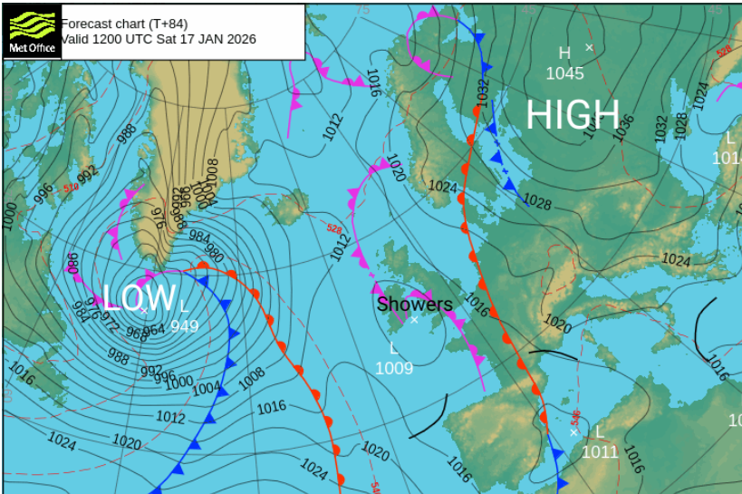
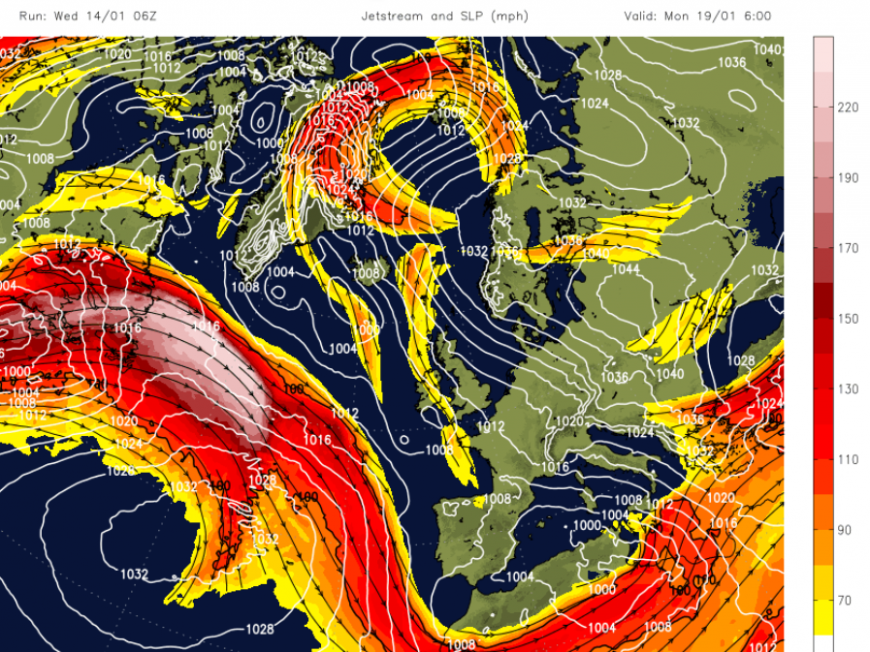
The UK will be in a Col, the slack area between two high pressures and two low pressures, by Saturday. Cols are renowned quiet zones. There is a stormy low away near southern Greenland, with some wild weather from Newfoundland haeding to Greenland for the start of the weekend.

There is a huge meander in the jetstream which disrupts with a cut off low heading north to the Arctic and the more southern portion dipping away into northern Africa. Nothing near NW Europe to fire up another storm close to the UK for a while. Air from the southeast will try to reach over the UK from the continent as the Atlantic struggles to have much effect by the end of this weekend.
Saturday
After a chilly and damp night, many places will start off rather grey and feel cold even with only a light breeze. Northwestern Scotland and County Fermanagh could see ice with clear skies and sunshine here and there will be a scattering of showers. These move from the southwest and round the Irish Sea. Further east, there could be fog in the morning, even freezing fog so something to bear in mind if you are travelling on Saturday morning in eastern England.
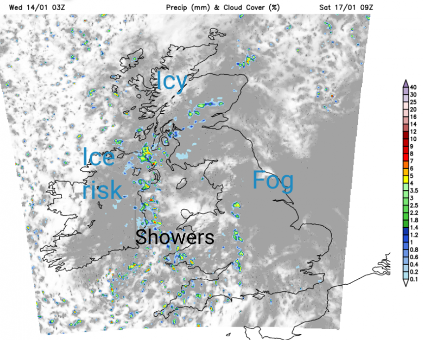
There will be clusters of showers with some heavy bursts. The UKV model takes these over Wales, northwest England and Belfast in the morning. For many, it will be a mundane day but just keep an eye where these showers end up. Temperatures will be around 6 to 8C, about average. For those organising or taking part in ParkRun the conditions could still be tricky underfoot. Although the weather is quiet, there is still mud and a bit of ice to consider.
Snow and Skiiing
The heavy rain earlier this week has impacted the snow cover in the Nevis Range. There are some good bases for the Cairngorm ski slopes, although it has been rather windy. The lighter winds this weekend will be good news.
There will be a bit more snow for the resorts in western Scotland through Wednesday night and Thursday morning. Even extending across to the Cairngorms overnight. There is still lying snow in rural Grampian but also thaw and flooding problems after the rain and the higher temperatures at the start of this week. So if you are walking in the hills or mountains this weekend, prepare for wet snow conditions.
Early on Friday morning, there could be wintry conditions for high ground of northern Britain, including the Pennines and Cumbrian Fells but that is about it. At least the snow gates should remain open and the winds will be light across Scotland this weekend. It could be icy for northern Scotland though.
Sunday
Sunday could see a few more sunny spells. Overnight, there will be clusters of showers moving east or northeast with many areas staying dry in between. The winds will still be light but there will be more areas with a risk of ice, seeing frost or fog on Sunday morning. A southerly breeze will pick up through the morning, stirring away any fog. Again there could be a few rain showers in a band from the west with a frontal band edging closer from the Altnatic. With a freshening southerly wind, there will be increasing cloud and the threat of rain from the northwest. Temperatures will be similar to Saturday. There is a waving weather front over NE France which could sway over Kent bringing patchy rain to the Home Counties and East Anglia for Sunday afternoon.
Ongoing fallout from Storm Goretti
Southwest Water are continuing with bottled water stations in Cornwall, assisting people who still don’t have running water after Storm Goretti last Thursday night. Many customers do now have running water once more but the cleanup from falling trees and other damage continues. A quiet weekend of weather will come as a bit of good news although Saturday looks chilly for Cornwall.
The National Grid announced on Wednesday- Storm Goretti Update
“We are pleased to announce that following the recent storm, everyone is now back online. We would like to thank our colleagues for their tireless efforts day and night, working in difficult conditions to restore power.”
There has been significant disruption to the power network over several day with welfare vans serving hot drinks and food and supporting members of the community. It is worth looking at the Priority Services Register, in preparation for severe weather and the possibility of power outages. It is a free UK wide service which provides extra advice and support, including when there’s an interruption to your electricity, gas or water supply.
South East Water is also having to provide bottled water in Kent and Sussex after the storm (and recent cold weather). There was direct damage to water mains, low water storage and loss of power to treatment and pumping systems. Households in the far SE are continuing to experience no water or low pressure following the recent outages. The water supplies are returning in Kent and Sussex “following the recent cold weather and subsequent breakout of leaks and bursts which resulted in our drinking water storage tanks running very low.” SE Water
“This is a slow process as it’s a vast network of pipes which need to be carefully filled to avoid creating bursts which would delay restoration… and we have teams clearing airlocks…our teams are working to repressurise the network.”
A quiet lull will be helpful this weekend.
Loading recent activity...