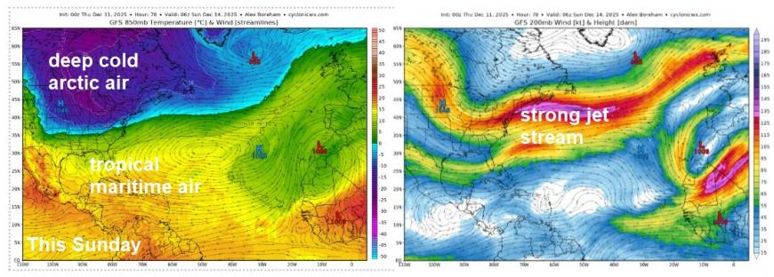
There has been suggestions that the unsettled weather pattern dominating at the moment has similarities with the weather patterns that dominated winter 2013-14, with very cold air over eastern North America, like now, driving a strong jet stream over the North Atlantic towards the UK, bringing low after low.
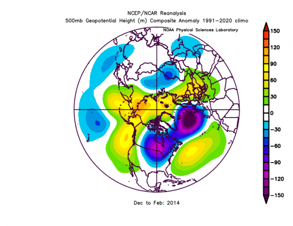
500 hPa anomalies Dec-Feb 2013-14, blues are low heights/pressure
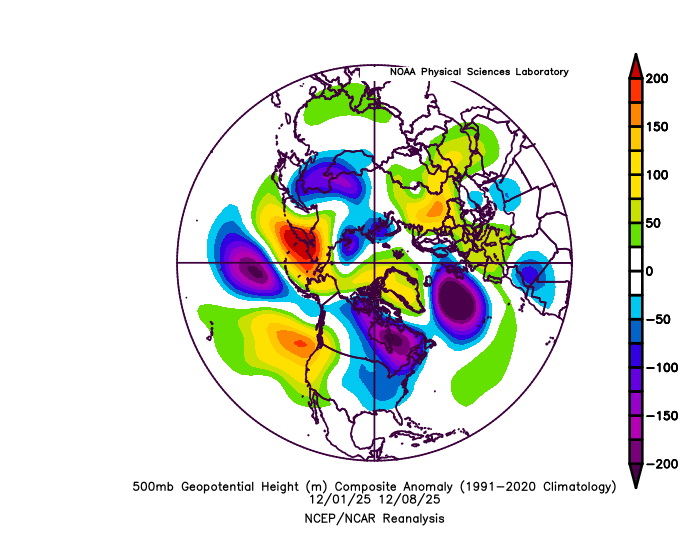
500 hPa anomalies 1st - 8th December 2025, look similar to above?
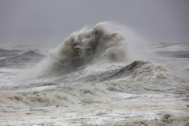
The winter of 2013-14 was exceptionally wet and stormy, making it the wettest winter for England and Wales since at least 1766, according to the Met Office. That winter, the weather was characterised by record-breaking rainfall, strong winds, and a series of major storms that led to widespread flooding across the UK, particularly across southern Britain, the Somerset Levels and the River Thames Valley were particularly affected by severe flooding.
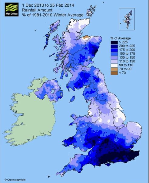
Although December 2013 started with high pressure across the south, between the 5-6th, a deepening low named Storm Xaver passed Scotland then across Sweden 5-6th as an intense low, there was a notable storm surge along the North Sea coast with flooding on the A gust of 93 mph was recorded at Altnaharra in Scotland and northern Germany and there was widespread disruption across northern Europe; 400,000 homes lost power in Poland. Thereafter, after a quieter week, the weather turned increasingly disturbed, with a sequence of major storms from mid-December to early January that brought gales and heavy rain. The weather then remained very unsettled before a further rapid sequence of storms from late-January to mid-February. The storms often arrived in rapid succession or “clusters” which contributed to the exceptional rainfall totals over the British Isles that winter.
The exceptionally wet and stormy winter in the UK in winter 2013-14 was linked to very low temperatures on the North American continent – which were much below normal in the eastern USA, particularly in January 2014. The contrast between cold arctic air advecting south across the USA, and the warm tropical Atlantic are likely to have been partly responsible for the persistence and unusual strength of the North Atlantic jet stream - which created ideal conditions for generation of storm systems tracking across the UK.
Similar to much of winter 2013-14, particularly late December onwards, the tropospheric polar vortex since the start of this December has been displaced south over Canada, parked over the Hudson Bay area. This vortex is feeding waves of very cold arctic air south across central and eastern USA. Where the deep cold meets warmer tropical maritime air over southern US States and across the NW Atlantic, it creates a steep thermal gradient that fuels a strong jet stream east across the North Atlantic towards NW Europe, bringing low after low after low.
However, there are differences to the current and forecast patterns this month compared to that winter.
During winter 2013-14 there was an anomalously strong stratospheric polar vortex, likely related to the westerly phase of the Quasi-Biennal Oscillation (QBO) in the tropical stratosphere. However, this winter is starting with a weaker than normal stratospheric polar vortex perhaps related to being in the easterly phase of the QBO, which tends to favour this. So there are differences in the global drivers this winter than that one.
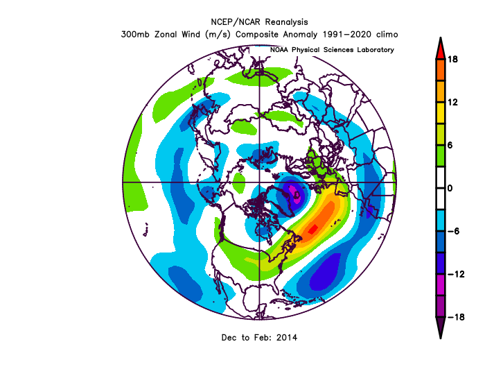
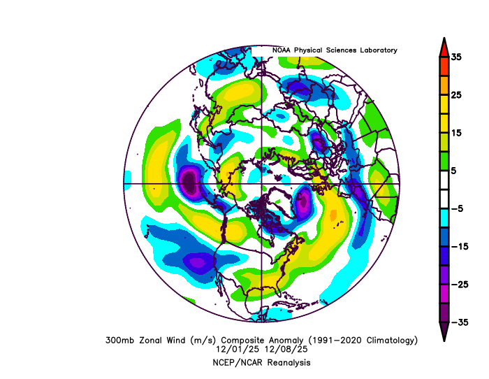
Jet stream (300 hPa zonal wind) was tracking further south into Europe in 2013-14 winter, compared to recently tracking NE over NW Europe
2013-14 winter 300 hPa zonal wind
Dec 1st - 8th 2025 300 hPa zonal wind
Also, in January and February 2014, during the most stormy period that winter, the jet stream was often tracking further south and deeper into mainland Europe, bringing areas of low pressure directly over the UK, with wettest conditions across the south, whereas recently and over the next week or so, the jet stream has been directed northeast towards northern UK then on in across Scandinavia, with areas of low pressure tracking to the north of the UK. This has forced high pressure to persist across mainland Europe, bringing southwesterly and sometimes southerly winds, with highest rainfall totals across the west, where there has been over a month’s worth of rain already only a third of the way through the month, while eastern areas have seen rainfall closer to average.
So, although there is the similarity of very cold conditions over eastern North America driving a strong jet stream over the North Atlantic bringing unsettled and sometimes stormy weather to the UK and Ireland, the track of the jet stream and areas of low pressure and distribution of rainfall is different to that dominated January and February 2014 - which saw the worst of the flooding, though there are similarities to this month to December 2013 in that high pressure was dominant over mainland Europe, before being less of a feature in New Year 2014 with the more southerly tracking jet stream.
The tropospheric polar vortex which has been displaced south over Canada since the start of the month looks to lift back north towards the pole over the coming week or so, this will mean the deep cold will relax over eastern North America, but the North Atlantic sector will still remain very cyclonic, with further lows affecting the UK, bringing bouts of wind and rain at times.
There are hints that high pressure may build around the festive holiday period, bringing drier, more settled and perhaps chillier conditions, but low confidence on this for now.
Loading recent activity...