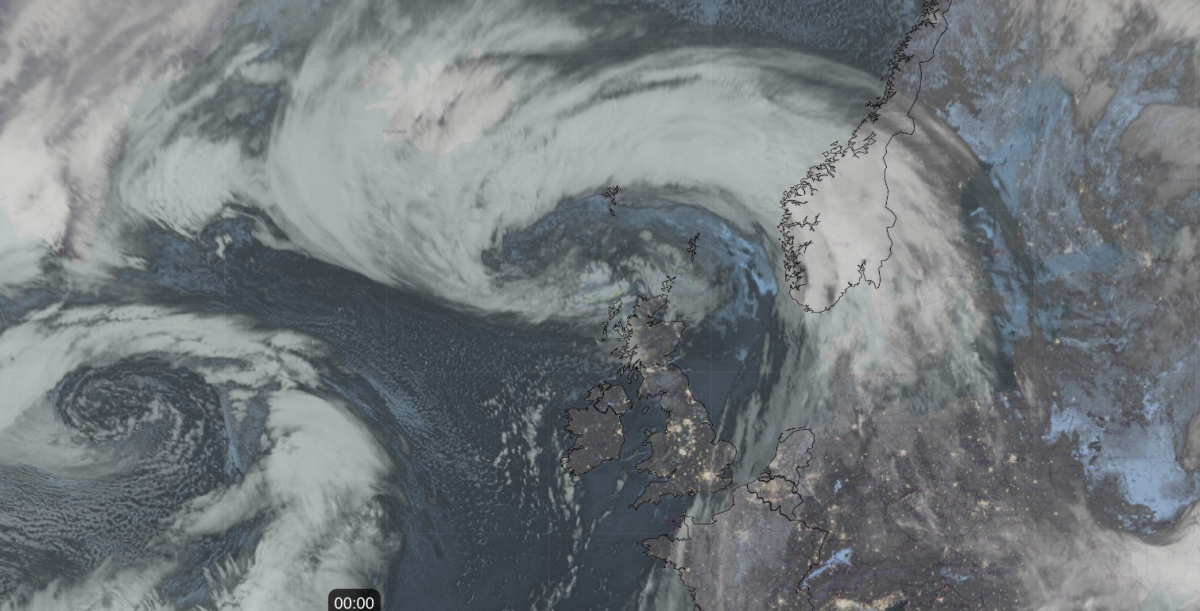
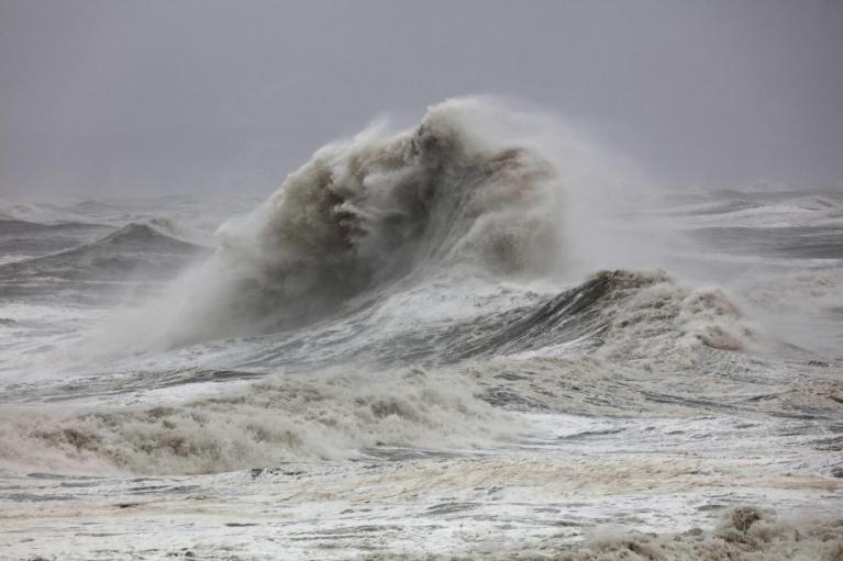
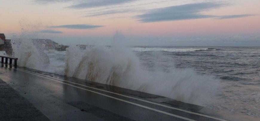
Storm Bram brought heavy rain on Tuesday with Amber rain warnings from the Met Office. Met Eireann had named the low pressure which deepened as it moved northwards with numerous wind warnings for the island of Ireland, even red marine warnings along the coast. Later in the day, gales set in for western Scotland with wild conditions across northern Britain as travel disruption increased. NW Scotland saw an Amber wind warning into the night as the low centre passed by.
Several vehicles overturned on the M74 in Dumfries & Galloway on Tuesday, which had to be closed. A diversion route was put in place but with lorries on their sides, authorities were asking people in southern, and western, Scotland to consider if their journeys were necessary. Ferry journeys to the Islands had already seen disruption and cancellations as the storm raged into the night.
On the railways there are speed restrictions early on Wednesday while inspections continue and there has been damage to overhead wires on a line south of Glasgow, due to a falling tree yesterday.
Across Ireland, there have been power outages through the night with thousands of properties losing their electricity supply.
“We're assessing the damage to the electricity network caused by the recent weather event. We'll provide updates on the estimated restoration times as soon as crews have evaluated impacted areas. Thank you for your understanding.” ESB Network
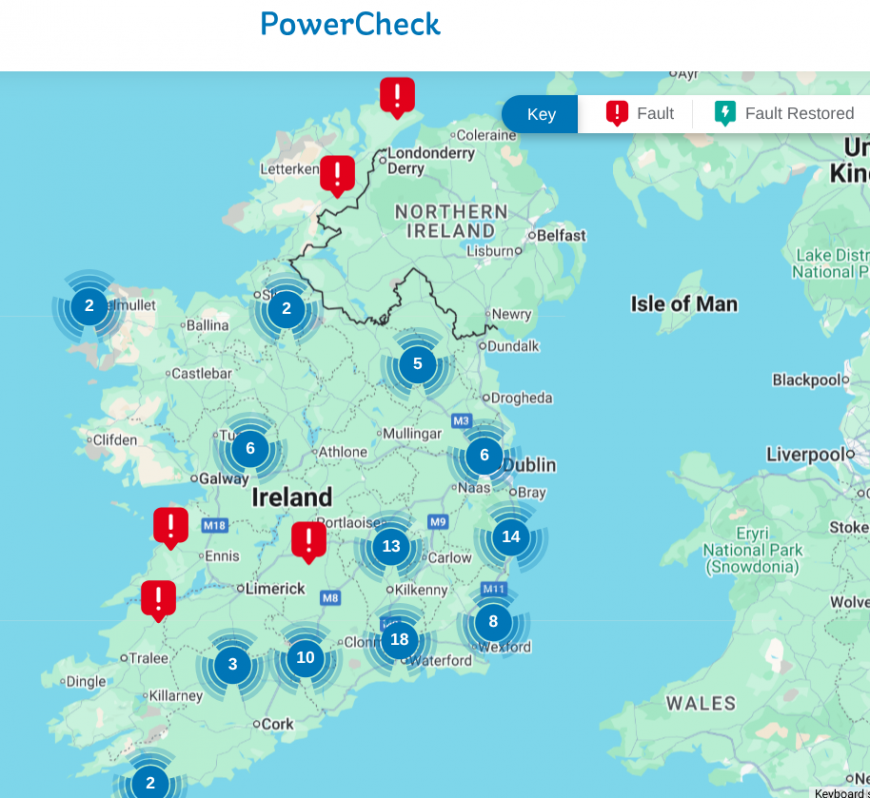
Northern Ireland Electricity Network “Due to the number of faults we are currently experiencing on the network, we are unable to provide an estimated restoration time for your electricity supply at this time. We are working to restore supplies as quickly and safely as possible.”

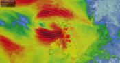
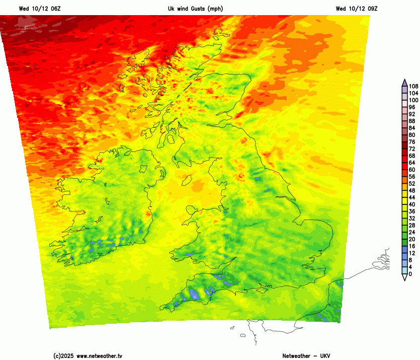
Top wind and gust strengths by mid evening on Tuesday 9th Dec from Netweather Live
Winds
As the deepening low moved near NW Scotland it as a wild commute home for some. With lashing rain and sudden high gusts. Western Wales experienced gusts over 80mph on Tuesday afternoon with winds of nearly 60mph which is Storm Force 10 on the Beaufort Scale. The Isle of Man recorded a gust of 76mph and over the tops of the Cairngorm mountains, the winds reached 89mph (Hurricane Force 12) with a gust of 112mph.
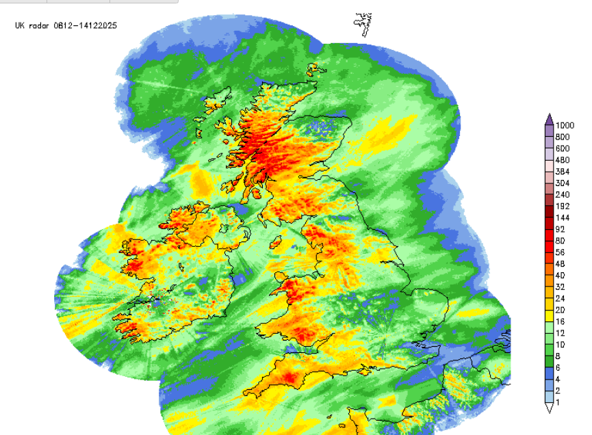
Rainfall totals for first part of the week, mostly from Storm Bram- red showing higher totals in the west
Rain and Flooding
After recent rain, the heavy rain from Storm Bram’s fronts brought surface water flooding and added to river levels. Tucking around the low, there were further clusters of heavy showers into the evening. Nantyglo, South Wales recorded 62mm of rain on Tuesday.
“Local ongoing river flooding is possible on Wednesday and Thursday following the recent heavy rain.” Env. Agency
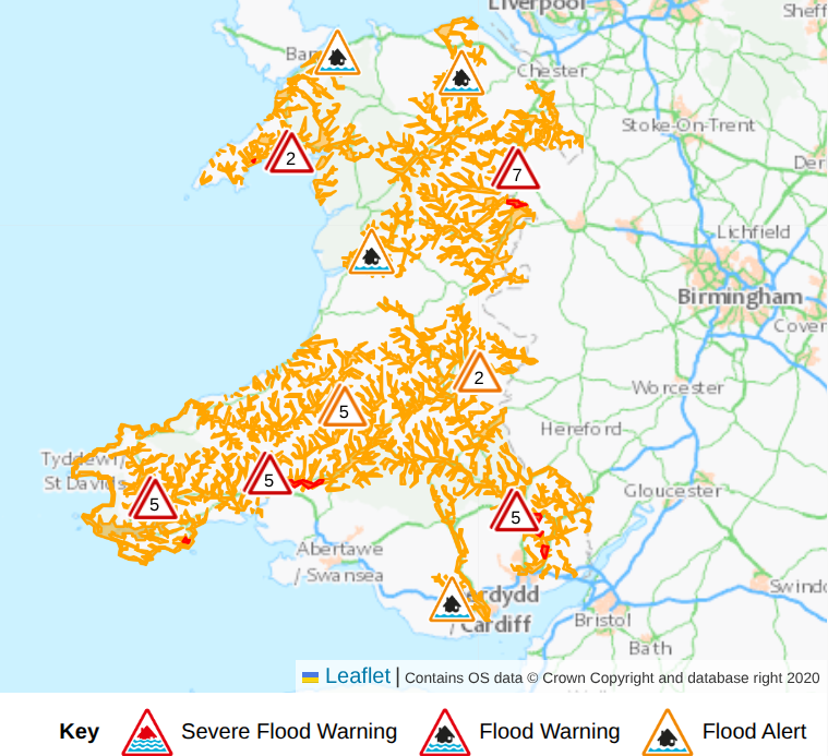
Natural Resources Wales flood updates Weds 0755am
In Scotland, flooding from coasts continues to be likely “along western and northern coastlines, the Western Isles and the Northern Isles due to very strong winds, large waves and surge from StromBram and high tides. Danger to life from wave overtopping, property flooding, flooding of roads and disruption to infrastructure are possible.” Scottish Flood Forecast.
The next heavy rain comes from frontal bands arriving from the NW on Saturday but sliding over Wales later in the weekend. Some uncertainty, but NW England could see high rainfall totals and western Scotland.
Netweather Radar Extra showing top wind speeds and top temperatures after 6pm Tuesday 9th
Very mild Storm Bram
The air flow from the south originated in Spain and NW Africa. Temperatures rose widely into double figures with Carlisle reaching 16.8C. This broke the highest temperature on record for 9th December, which was formerly 16.7C in Torquay, Devon from 1921!. Northern Scotland passed 15C by day after a chilly start when there had been a frost. Fyvie in Aberdeenshire fell to -1.5C in the clear skies before Bram progressed northwards. Eastern England passed 14C all of these temperatures being well above average for early December. However, the rain and strong winds did take the edge of the mild air.
Wednesday warnings
Met Eireann has coastal marine gale warnings throughout today. There are Met Office yellow wind warnings across much of Scotland, apart from the far south, along the border.
“it will remain very windy across the Hebrides and western coast. However, another spell of strong westerly winds will develop for a few hours through the afternoon, with gusts widely 50-60 mph inland, and 70-80 mph along exposed coasts and high ground of the Outer Hebrides, northwest mainland and Orkney.” MO
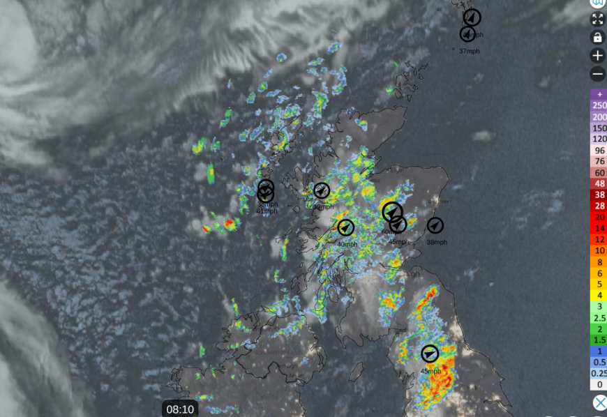
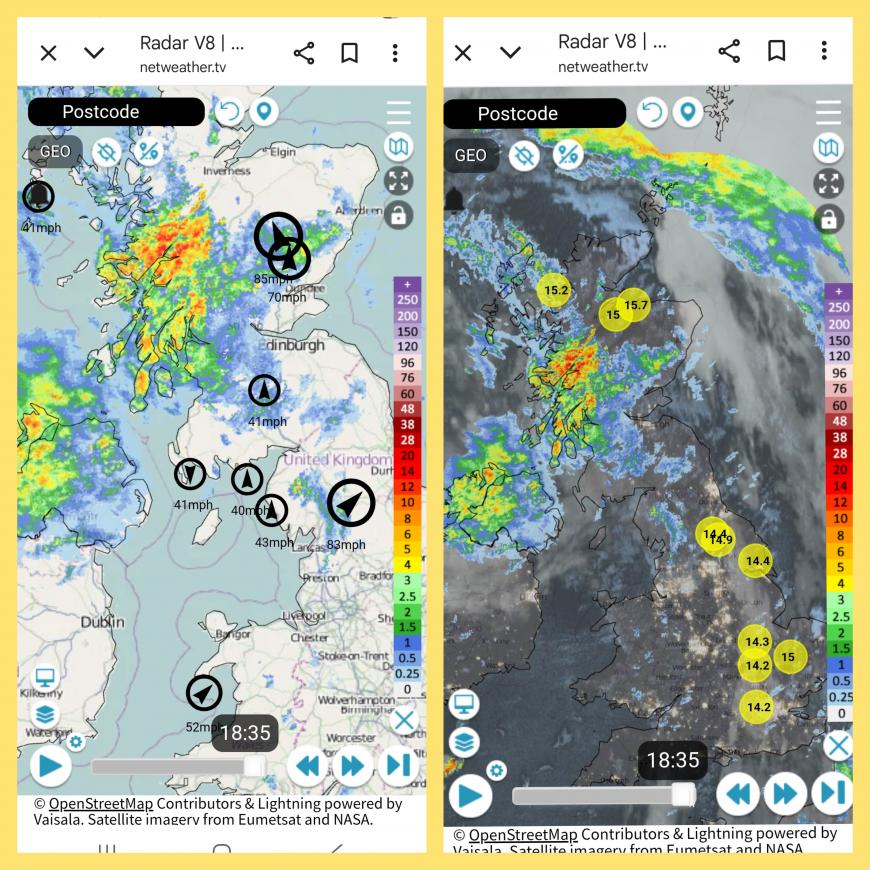
Wednesday morning Netweather Radar showing clearer skies, showery clusters and strong winds
Storm Bram will be slowly filling today north of Scotland but still a deep low pressure bringing a windy day in the north and a blustery southwesterly flow across central Britain. There will be severe gales and very rough seas for the Northern Isles today with ferry, and air travel, disruption
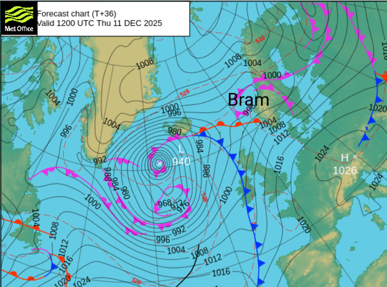
Storm Bram will sidle off to western Norway as a new complex low pressure throws its cold front our way on Thursday. However, the low centre will rapidly deepen closer to Iceland. It stays windy for Scotland, Northern Ireland and around the Irish Sea overnight and into Thursday morning.
More discussion and chat about Storm Bram on the Netweather community.
Loading recent activity...