Met Office provisional figures suggest autumn was wet and mild, with temperatures and rainfall above average. Northern Ireland recorded its third wettest autumn on record, while Wales recorded its 10th wettest.
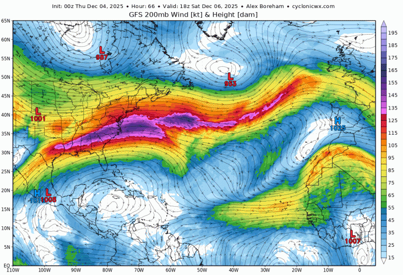
The first half of December is looking wet and mild too, with a strong westerly jet stream over the Atlantic aimed at the UK bringing low after low towards NW Europe - which will mean it will be rather unsettled, with showers or longer spells of rain affecting many areas. It will be windy at times too, with gales possible - especially around coasts. Temperatures will generally be on the mild side too, with the flow from the southwest or west.
The UK & Ireland will be at the end of a strong jet stream

Increasingly mild air off the Atlantic from the weekend across the UK and much of Europe
The strong jet stream bringing a conveyor of low pressure systems off the Atlantic is being driven by a large temperature contrast over the NW Atlantic and eastern USA. This is being caused by the tropospheric polar vortex dropping south and taking up a position near Hudson Bay, Canada, directing rounds of Arctic air southward from the North Pole across Canada to parts of the central and eastern United States through to the middle of the month. Temperatures across north central USA could drop as low as -25C to -30C at night. The frigid cold air meets warmer sub-tropical air towards Bermuda, Florida and the Gulf States producing a steep thermal gradient - driving the strong jet stream across the Atlantic towards NW Europe.
Deep cold air from polar vortex over Hudson Bay, Canada spilling south over USA driving a strong jet stream downstream over the North Atlantic towards NW Europe
Until the waves of deep cold dropping southeast across Canada and the eastern side of the USA ease, then we will continue to see a strong zonal (westerly) jet stream across the Atlantic driving low after low towards the UK.
It will become increasingly windy over the coming days and there is potential for one or two deep lows passing near or over the UK next week and perhaps the week after, recent model runs have been hinting at a low coing out of North America passing near the Azores at the weekend deepening rapidly as it moves northeast close to our over Ireland then northern Britain early next week. However, it's far off to have any confidence in such a scenario. But one to keep and eye on.
.jpg?w=800)
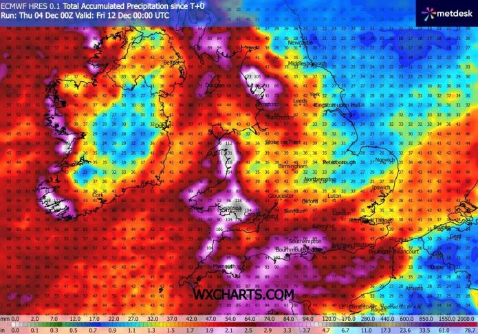
As well as potential for strong winds, rainfall totals will be adding up over the coming days, with the ground already saturated in parts of the west, further rain will mean river levels will be getting high, with flood alerts and warnings on the increase. Western areas and the far south look to see the highest rainfall totals. Over 100mm forecast by ECMWF over the moors of SW England, the far south of England, Wales, Cumbria and western Scotland by this time next week - these areas most exposed to the moist southwesterly flow.

Any signs of more colder and festive weather on the horizon nearer to Christmas? No signs of a change to bring colder weather for now, but Christmas is over 20 days away, so it could change by then. But as long as eastern North America remains in the freezer and this cold air is spilling out over the NW Atlantic driving a strong jet stream towards NW Europe, then its looking likely to remain unsettled and mild with plenty of wind and rain.
Loading recent activity...