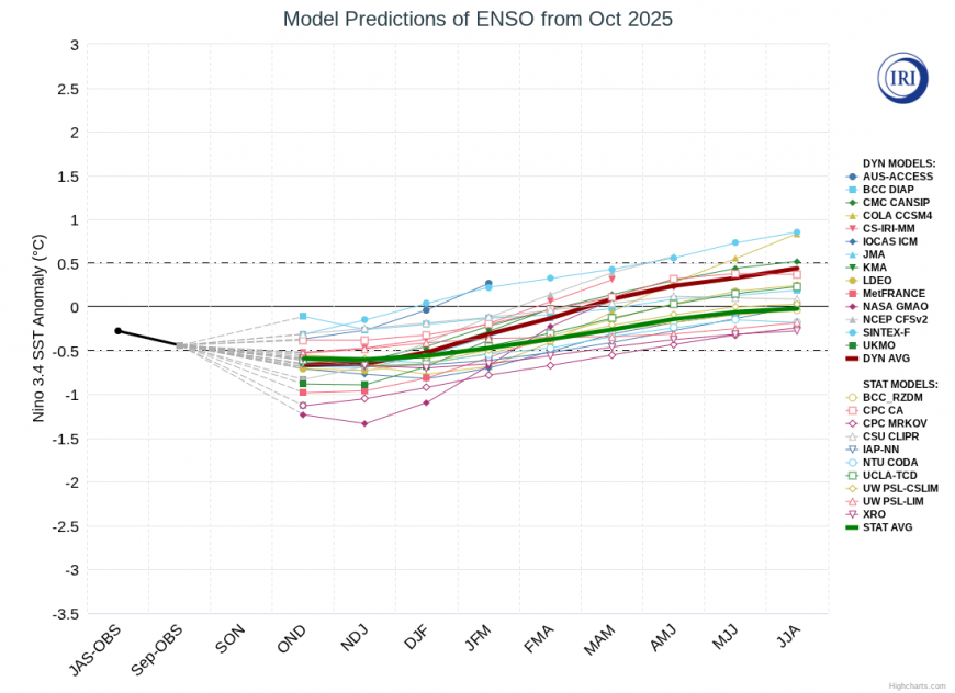
This winter is looking set to have a weak La Nina event, followed by a transition to near neutral El Nino Southern Oscillation (ENSO) state as we head into next spring. Since around 1980, winters with a weak La Nina event have tended to be relatively cold. This is in contrast to winters with a strong La Nina (an index of -1 or below), which have tended to be mild, changeable and dominated by westerly winds, the only exception being 2010/11 which had that exceptionally cold December.
The most recent example of a winter with a weak La Nina was last year. The 2024/25 La Nina was generally forecast to turn out stronger than it did, and this and other factors contributed to forecasts of a mild winter, but in the event it was relatively cold for recent years. There was an early spell of cold and, for some, snowy weather between 18 and 23 November 2024, and after a mild December, January was on the cold side and February had a spell of easterlies, although February as a whole turned out quite mild.
But, as is increasingly the case with the warming climate, for many of us it wasn’t a particularly snowy winter by long-term historical standards. January 2025 had some snowfalls in the first week, which gave a prolonged period of snow cover to some, especially in the north and on high ground, but some areas saw rain and sleet instead in that spell. I recall that here in Lincoln there were two falls of wet snow that didn’t lie for long, and that an icy spell followed, as the heavy precipitation resulted in some flooding and then the flood waters froze over. February’s easterly was very tame, due to mild temperatures to the east of Britain during that spell, although a notable cold spell did develop in eastern Europe. Many parts of eastern Britain saw only rain from it, with temperatures hovering at around 3 to 5C.
The other winters that stick out for analogous ENSO conditions since 1980 are 1983/84, 1995/96, 1996/97, 2000/01, 2005/06, 2016/17 and 2017/18.
2017/18 was the winter with the notorious “Beast from the East” at the end of February, which saw numerous snow showers especially in the east and daytime temperatures generally below freezing, and then spells of persistent snow as Storm Emma collided with the cold air mass. It had been a relatively cold and snowy winter up to that point as well, with some wintry spells especially in the second week of December, and in the north around 29 December and 16-21 January. 1995/96 was another cold snowy winter, 2000/01 had closer to average temperatures but also had a number of wintry spells. 1996/97 started off cold and dry with a notable “easterly” snowfall at the end of December, but turned very mild and wet into February.
There are also a few dry anticyclonic winters in there, 2005/06 and 2016/17, with 2016/17 coming out relatively mild but with some cold snaps in January and in the first half of February, which generally didn’t deliver much snow at low levels.
But I get an impression that as our climate has changed, some of the analogues from the past may no longer work as well as they used to. The failed forecasts for a mild winter in 2024/25 can at least partly be explained by La Nina being weaker than forecast, but 2023/24 was widely forecast to be a cold winter, especially in January and February, but while we did get some Greenland blocking highs, apart from a cold spell in the first half of January, we had an arm of the jet stream passing through Britain which kept the cold air mostly locked away over Scandinavia, with mild and wet weather prevailing especially in England and Wales.
Many of the above winters with a La Nina also had some sort of wintry spell in November, and this still can’t be ruled out for November 2025, despite the forecast for mild and changeable weather in the first half. November 2005 was very mild in the first half but had a very cold second half, with quite widespread snow around the 25th-28th, including, unusually, big snowfalls across Devon and Cornwall on the 25th. But at the moment, for the foreseeable future it looks set to be mild and changeable.
We are currently in a bit of a cold snap at the moment with northerly winds, but this one is proving rather tame compared with some other late October cold snaps in the last 25 years, with sleet and snow confined to high ground. I had thought there may be a possibility of sleet and snow showers getting to low levels in northern Scotland, but in the event we have picked up more of a north-westerly rather than a direct northerly, and so the air mass is not quite as cold as was previously forecast by many model runs. It looks probable that there will be quite a widespread ground frost in the north tonight.
But after this weekend, the weather looks set to become mild and changeable, with mainly south-westerly winds and temperatures mostly above the seasonal average, and it looks likely to stay this way for much of the first half of November. High pressure may become more prominent in the second half of November, but with a lot of uncertainty over where the high will end up.
Loading recent activity...