Thought I’d update on my early look at what may lie ahead for winter 2025-26 blog issued on the 9th, as La Nina has been declared and the seasonal models have all updated for October, so we will have look at whether this changes or further backs up my earlier thoughts.
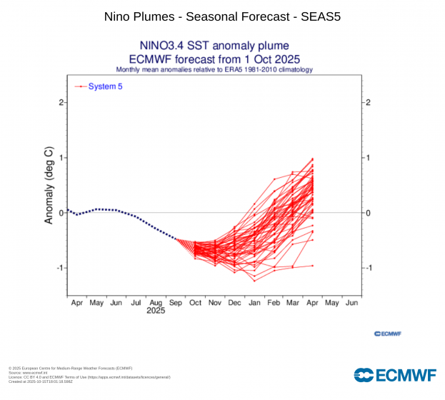
A La Niña advisory was issued on the 9th October by the US Climate Prediction Center (CPC). The advisory stated that “La Niña conditions are present and favored to persist through December 2025 – February 2026, with a transition to ENSO-neutral likely in January-March 2026.”
The CPC’s La Niña definition is based on sea surface temperatures in the central equatorial Pacific Ocean being at least 0.5°C cooler than average, and an expectation that this region will remain below this threshold for at least three consecutive months.
In addition to this ocean component, there also needs to be clear signs of an atmospheric response above the tropical Pacific Ocean for La Niña to be declared by the CPC.
While not the only influence, La Niña's cooling effect on the equatorial Pacific waters can affect weather patterns thousands of miles away, including North America, the North Atlantic and Europe. However, 4 of the past 5 winters have seen La Niña, and each of those 4 winters saw very different outcomes occur. This is because other drivers in tandem with ENSO can create different outcomes, depending which cycle or phase they are in. But, also, the strength of La Nina and position of the cold anomalies in the tropical Pacific can influence the outcomes. A strong La Nina typically favours a positive North Atlantic Oscillation (+NAO) in winter, bringing mild and stormy weather to the UK. While a weak La Nina, especially in combination with a negative QBO, which will discussed shortly, can favour more blocked weather patterns and greater chance of colder weather. Other factors, such as solar cycle, snow and ice cover, MJO, etc, can also combine and influence outcomes.
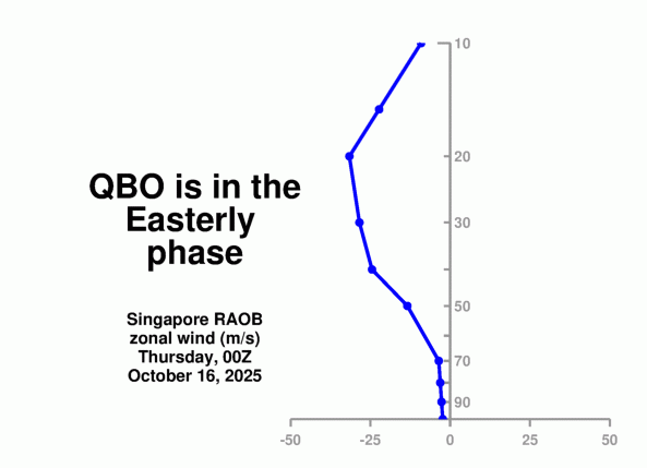
The Quasi-Biennial Oscillation (QBO) is another important driver that can help drive different outcomes during winter with the same ENSO phase, depending on whether the QBO is in westerly or easterly phase. September’s QBO came in at -24.26 - indicating we are currently in a descending strongly easterly QBO episode. These periods are associated with increased cross polar flow with a weaker and displaced polar vortex, with storm track further south, a characteristic of a negative North Atlantic Oscilation (+NAO) - which can bring colder weather to NW Europe, including the UK and Ireland.
Conversely, during La Niña and westerly QBO phases, there is a strong correlation for a center of positive SLP anomalies in western and central Europe and strong polar vortex, characteric of +NAO.
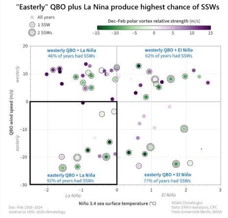
Also, an easterly phase of the QBO favours an increase in “sudden stratospheric warming” (SSW) events and polar vortex disruptions; especially, when combined with La Nina. Roughly 2 out of 3 SSWs, on average, have lead to cold conditions in the UK several weeks after wind reversals in the upper stratosphere that typify a SSW occur.
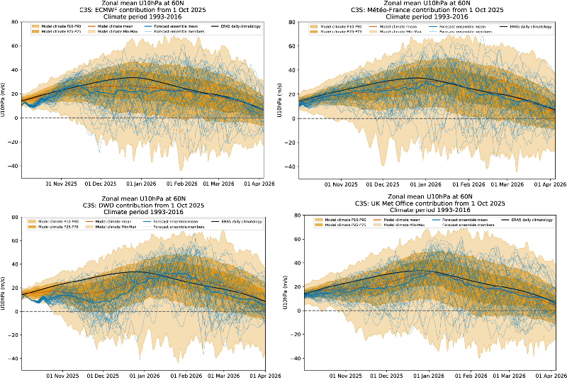
The CS3 seasonal forecasts were updated on 10th of October and most show, to varying degrees, a weaker-than-average polar vortex over the Arctic during early winter, particularly DWD and UKMO, less so ECMWF.
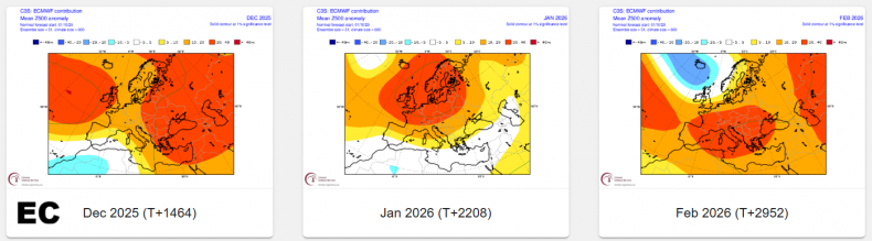
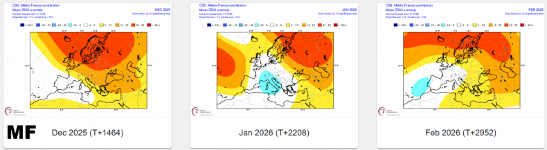
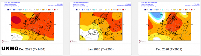
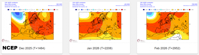
This is reflected in most of the 500 hPa mean anomaly forecasts for December and January - which signal a higher-than-average chance for high latitude positive height anomalies with a negative North Atlantic Oscillation (-NAO). The exception is the American NCEP (CFS) model, which has a +NAO pattern for all 3 winter months. February signalled by ECMWF, UKMO and NCEP (CFS) to have lower heights to the northwest over the far North Atlantic and higher heights over mainland Europe - typical of a +NAO pattern.
Seasonal forecasts for 500 hPa heights for DJF updated on 10th October. EC (ECMWF); MF (Meteo France); UKMO (UK Met Office); NCEP (American CFS model).
La Nina conditions are present and are forecast to persist through December 2025 - February 2026, with a transition to ENSO-neutral likely in January-March 2026. This La Nina episode is likely to be weak though.
The QBO is in a descending strongly easterly QBO episode that looks to also persist through winter 2025-26.
The combination of a weak La Nina and easterly QBO can increase chances of a weaker polar vortex at the start of winter, which means a greater chance for high latitude blocking with -NAO episodes bringing colder weather at times in December and January, but February more likely to see with stronger polar vortex - with a lack of blocking, consistent with a +NAO pattern bringing stormy and mild weather to the UK.
An easterly QBO favours an increase in SSW events and polar vortex disruptions; especially, when combined with La Nina. These SSW events can also lead to a greater chance of colder spells, especially mid-to-later winter.
Some, but not all, of the seasonal models are indicating higher than average heights over northern Europe or higher latitudes towards polar regions in December and January - which indicates a greater chance of a -NAO with blocking episodes both months, which may bring a greater chance of colder weather. February, the seasonal models generally suggest, though not all, a stormier and milder +NAO pattern.
Historically, La Nina has often led to a front-loaded winter for colder weather, while El Nino winters tend to be back-loaded for cold and tend to feature a mild start to winter and greater chance of a colder end. But this doesn’t always play true. Other drivers can work against or with ENSO and QBO forcing to determine the outcome of our winter weather, but these will be discussed more in the full winter forecast to be issued late in November.
Loading recent activity...