We’ve been talking about the threat of ex-Hurricane Humberto arriving near or over the UK since last Saturday, unleashing strong winds and heavy rain across NW Europe.
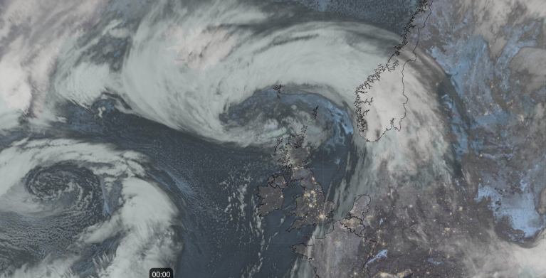
The models are now converging on the idea of a deepening low passing just to the north of Ireland then somewhere over or just to the north of Scotland during Friday evening / night, bringing very strong damaging winds to the north and west and heavy rain across many areas.
But, will it actually be Humberto hitting the UK? Obviously an ex-hurricane by then, as the cool waters near and around the UK can’t sustain a hurricane.
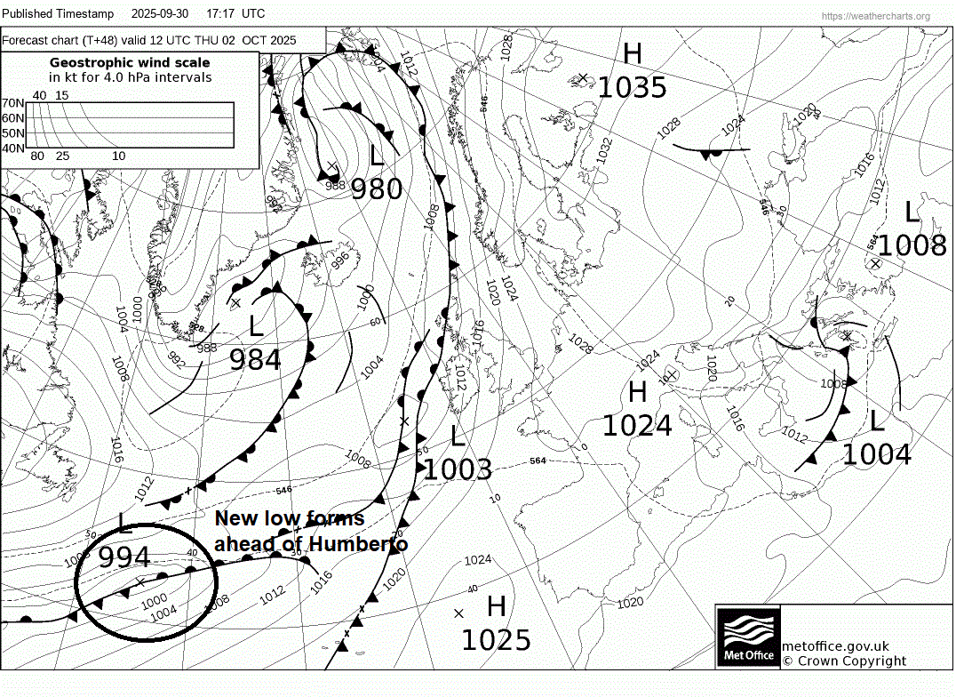
A new low forms ahead of Humberto along a warm frontal wave over NW Atlantic, created by the tropical warmth being pushed out by Humberto as it undergoes extra-tropical transition. And it's this low that deepens & heads to UK & Ireland for Friday. So, technically, it’s a new low that the Met Office may call Storm Amy rather than Humberto.
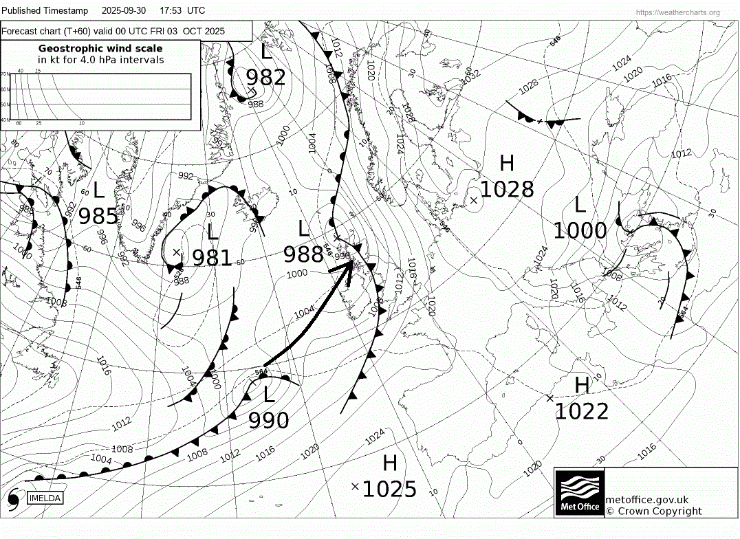
Humberto extra-tropical low looks to merge with the frontal boundary then its remnants may even be swallowed up by Imelda over the NW Atlantic too, while the new low forming to the northeast in the frontal wave races away to the northeast - picked up by a strong polar front jet stream racing across the North Atlantic around the base of an upper trough extending south from Greenland and NE Canada.
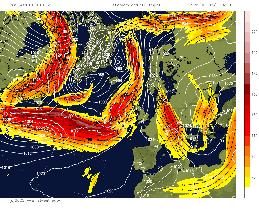
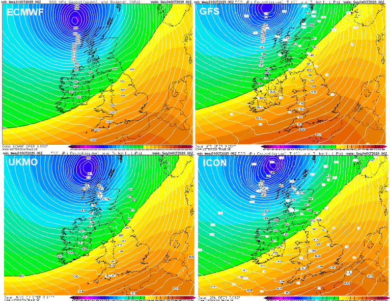
The low looks to then undergo explosive deepening on Friday, as it approaches the NE Atlantic and moves onto the cold polar side of a very strong 185 knot jet stream and also into the development left exit of the jet - where air diverges aloft causing a vacuum filled by air rising from the surface. This rapid deepening phase looks to occur as the low approaches the UK and Ireland, the low continuing to deepen as it moves near or over Scotland. Latest model runs this morning take the low to the north of Scotland.
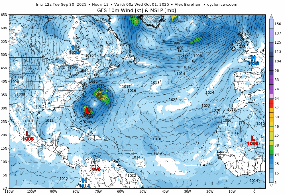
However, there is a wide enough spread of solutions on the track from the weather models and their ensembles to cast uncertainty still on the track of this low. Much of this uncertainty hinges on the nature of the extra-tropical transition of Hurricane Humberto and also its interaction with Hurricane Imelda. Both hurricane circulation are now connected - both in each other’s orbit. The models now suggest Humberto dissipates and hurricane Imelda robs its moisture and energy and swallows up the remnants of Humberto, leading to Imelda to grow over Bermuda as it passes over, bringing hurricane force winds to the islands.
All of this interaction between Humberto and Imelda may affect the timing and positioning of the wave development along the warm front. There is also then the uncertainty of timing of when the new low that forms eventually crosses the jet stream; the positions of the jet stream (further north and the low deepens further north). As when and where the low crosses the jet stream will be when it undergoes explosive cyclogenesis to the southwest of Ireland, the amount of time and degree to which the low has chance to deepen before it crosses close to or over the UK and Ireland. Which in turn affects the strength of winds.
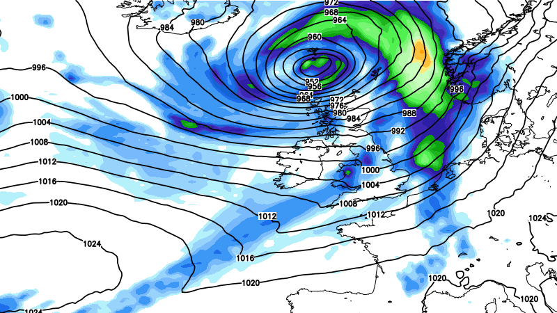
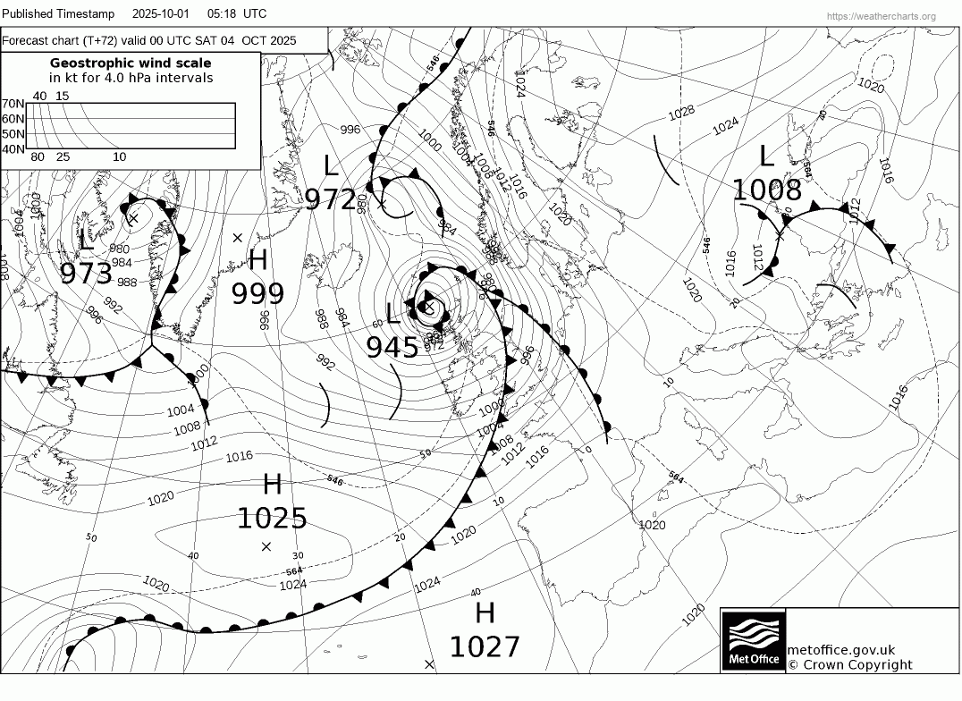
T+72 Fax chart for 00z Saturday shows a deep low with central pressure of 945 hPa passing close to northern Scotland
Strongest winds affecting northern and western Scotland on this morning's 00z UKV run
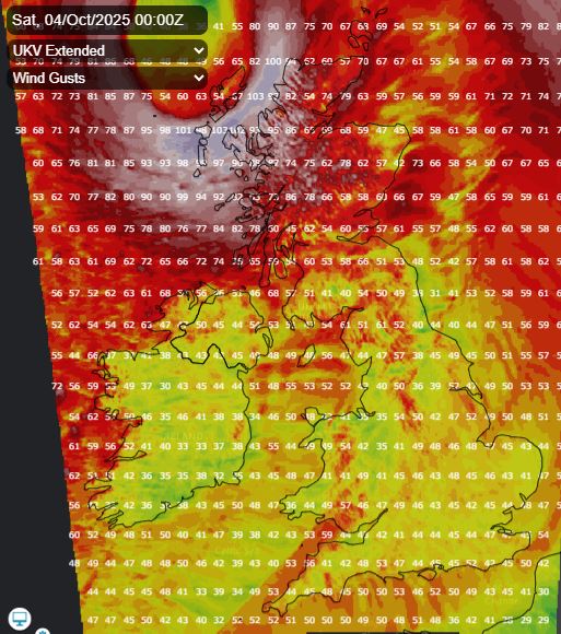
So, still a fair way off knowing the probable track, depth and timing of passage of this low on Friday, but it seems increasingly likely that very strong winds will bring travel disruption, more particularly for northern and western Scotland - where winds could be strongest i.e. gusting to 70-80mph with exposure.
Most of the overnight model runs have shifted the track of the low further north, with the low tracking northeast to the north of Scotland, likely due to the jet stream being modelled further north which means the low undergoes raid deepening further north. However, there is still chance the track may be shifted further south again, given the uncertainties discussed, which will bring the risk of severe gales further south.
Overnight runs take the centre of a deep low just north of Scotland Friday night
Expect the Met Office to issue warnings soon, likely an Amber warning for somewhere over Scotland, the north and west of Scotland based on current runs, yellow warnings for much of northern and perhaps western UK. The low will likely be named too, I'd bet on it being Amy, given it looks like a new low that forms and deepens before passing the north of the UK, but it could be Humberto if the Met Office / Met Eireann think that it is the orignal remnant low of the hurricane.
Loading recent activity...