We're into a persistent spell of winds from a north-westerly quarter that looks set to bring a complex and mixed picture for the remainder of the month. While this pattern can bring cool, showery weather, the influence of ridges from the Azores anticyclone - as has been the case this summer - means it will often be drier and warmer, particularly in the south. However, this flow will also bring variable amounts of cloud, making conditions fair rather than fine. This creates a risk of showers, mainly for the north and west, while the warmth in the south and east may occasionally trigger sharper, more localised downpours and even thunderstorms.
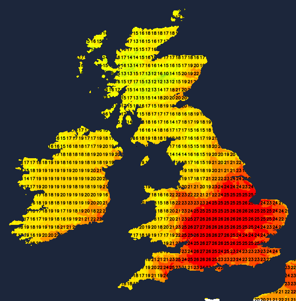
Thursday afternoon brings further showers to East Anglia and the South East, with a lot of cloud also across the East Midlands, giving the odd shower here. Elsewhere, it's a mainly dry story with sunny spells, but cloud amounts will vary. Top temperatures of 23∘C or 24∘C across parts of South Wales in the best of the sunshine, 19∘C to 22∘C more generally, but only 16∘C to 18∘C over North Scotland, with a northerly wind keeping temperatures down along North Sea coasts from the Humber southwards.
The showers will fade from the South East into the evening, leaving a dry night for most with clearing skies and light winds. Across Northern Ireland and the west of Scotland, however, an advancing front will bring cloud and some rain. In a mild night for most, temperatures will generally fall to between 11∘C and 16∘C.
Friday sees summer returning to much of the east and south, with a much brighter day and a fair amount of sunshine. Light west or south-westerly breezes will allow temperatures to reach a very warm 24∘C to 26∘C, with 27∘C or maybe 28∘C possible in the hottest spots. Further north and west, a weakening front will bring cloud and patchy rain, but the weather will improve from the west across Northern Ireland and Scotland through the day, giving some sunshine. It will be a bit cooler here, though, with temperatures of 18∘C to 22∘C near the mark.
As we enter the weekend, Saturday should bring the driest weather, but probably with more in the way of cloud across the southern half of the country. This could bring a few light showers, but with some warm, sunny intervals coming through here and there. The best of the sunshine, in a south-westerly breeze, could well be further north, making it a somewhat cooler day for the south, but top temperatures in the range of 18∘C to 23∘C will make it feel pleasant enough.
The mixed picture continues into Sunday, when more in the way of showers could be locally heavy in the south. Not everywhere will catch one, though, with some warm, sunny intervals in between.
Loading recent activity...