
France is being warned of disruptive, severe weather midweek as violent thunderstorms drift across the country later on Wednesday with temperatures again into the 30sC by day. There is a risk that storms could clip the far southeast of England on Wednesday night.
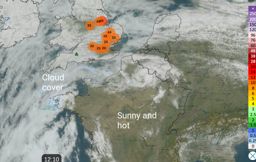
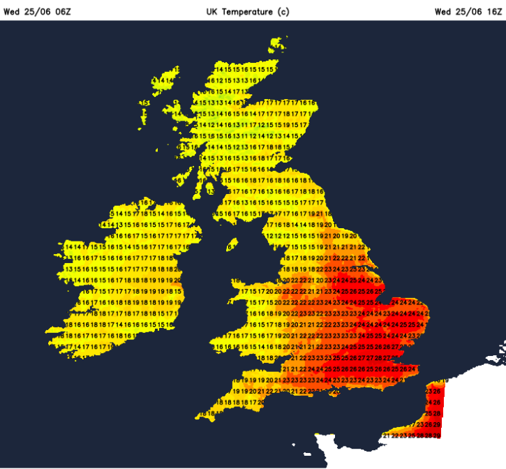
Here in the UK, it has been feeling warm and humid but there has been a lot of cloud. This has limited the temperatures. Wittering in Sussex reached 28C on Tuesday 24th, the top UK temperature that day. Charlwood in Essex saw the highest temperature this year on Saturday 21st with 33.2C (92F) as the heatwave in England peaked and intense thunderstorms broke out further north.
Across in France there are clear skies and brilliant sunshine. Not only is there the very warm air from the southwest, there is day on day heating from the sunshine. This is the 50th heatwave recorded by Météo-France, since 1947. It started on the 19th and peaked on Saturday 21st like the UK, but in France, the heat has continued.
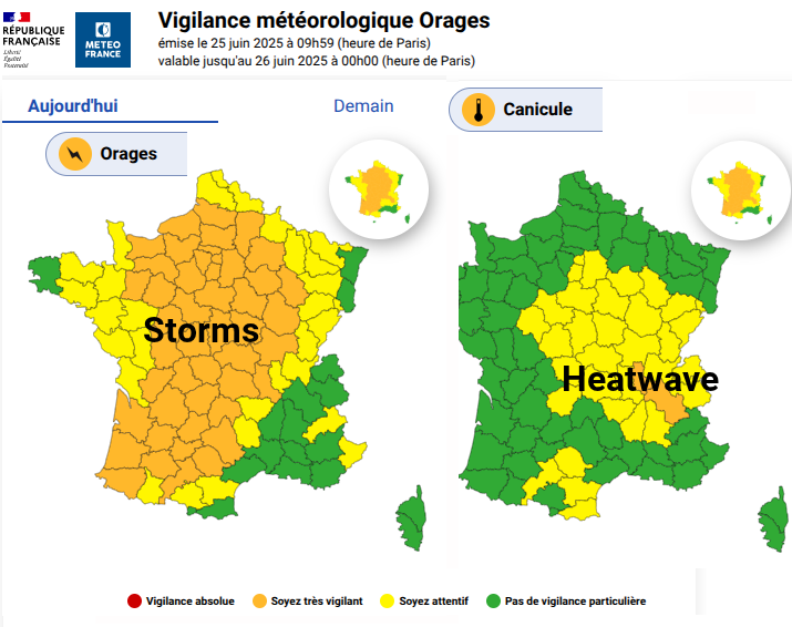
Meteo France has issued yellow and amber heatwave warnings for parts of France but they are now joined by storm warnings for Wednesday into Thursday. For us in the UK, it is feeling warm in any sunshine but it is southeastern Britain that has heat and more humid air today with temperatures in the mid to high 20sC.
Two things change overnight. One is an approaching Atlantic weather front that will bring rain from the west and allow a brief fresher clear of the heat and humidity later on Thursday for England. Thursday night will feel more comfortable for those who have experienced muggy, close nights. This flow from the west is important.
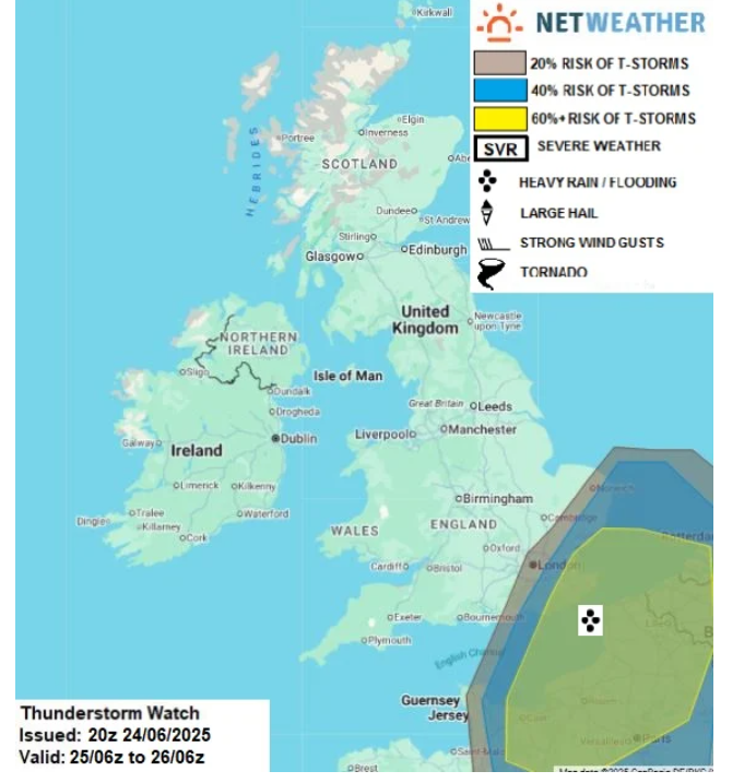
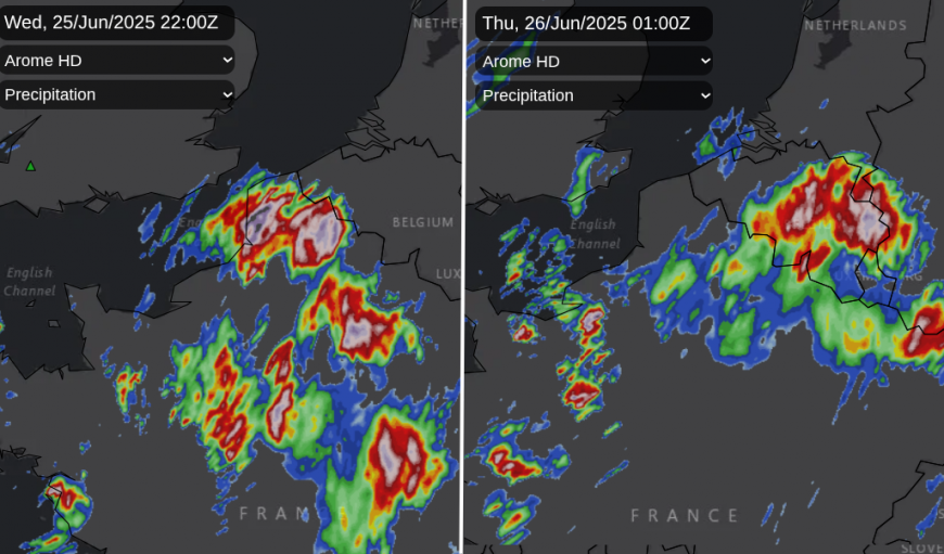
The second thing is the chance that the thunderstorms over France could affect SE England. At the moment, there seems a chance of storms clipping Kent, maybe East Sussex or Essex but also just missing. The drive from the west (that incoming cold front) could prove too much and could keep any French storms away from Kent and heading to the Low Countries and then Germany. For those along the Kent coast, this could still provide a dramatic lighting show by night. If you are having a look in the small hours, it's worth looking northwards too, as Noctilucent clouds have been spotted this week.
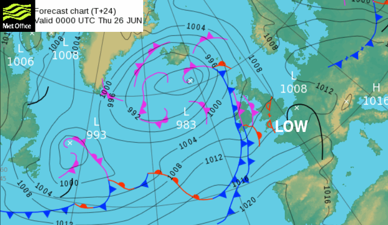
Convective forecast “An upper low just off Portugal on Tuesday will track northeast as a shortwave trough on Wednesday, approaching SE England and far N of France during the evening”. It will create lift ahead of it, destabilising a very warm and humid plume which will briefly move across SE UK.
“Elevated thunderstorms are expected to develop from the plume as a result over N France and the English Channel in the evening before moving NE across SE England overnight. Uncertainty how far west the risk of thunderstorms could be, but favour East Sussex, Kent and coastal East Anglia at greatest risk.”
Meteo France is warning of Severe weather later on Wednesday and overnight. Intense rainfall, severe thunderstorms with large hail are expected with even the risk of a tornado.
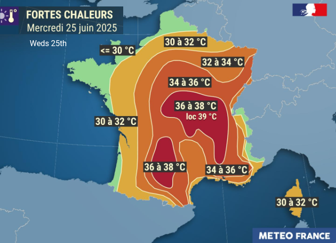
'Severe thunderstorms are expected in the late afternoon and evening across much of the country. Previously, the extremely high temperatures will spread northward and reach as far as the Île-de-France region.' Meteo France (including Paris with 32C forecast today)
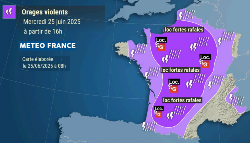
There is mention of ‘strong, locally violent thunderstorms’, also ‘locally, violent wind gusts, potentially exceeding 70mph with medium to large hail (2 to 5 cm, or even more)’, and frequent lightning.
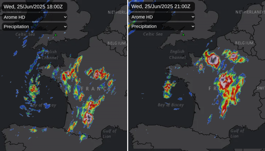
The Esofex forecast highlights the risk of severe weather across France later today, with the potential of a “high impact severe thunderstorm event” with “an outbreak of organised thunderstorms”. This mentions the possibility of very large hail being possible, over 5cm and possibly up to 10cm. If MCS (Mesoscale Convective System - a cluster of thunderstorms acting as one) develop and move over central France, possibly northern France, conditions will deteriorate suddenly with poor visibility, wild gusty winds, torrential rain and serious damage is possible.
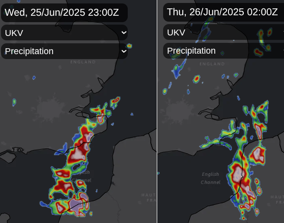
Now the question is will any of these cells reach across the English Channel to SE England?
If they do, “Storms could produce intense downpours leading to localised flash-flooding, strong wind gusts, hail and frequent lightning.” Convective forecast. For most, it will be a case of watching the Netweather Radar (with lightning sferics turned on) and keeping an eye on the distant horizon. Staying inside is the safest bet.
You might spot Altocumulus Castellanus along the south coast of Britain this afternoon and in the early evening. The tell-tale cloud signal of medium level instability, which look like battlement turrets. Elevated storms over northern France will progress northeastwards and then we watch on the radar. There will be some outbreaks of showery rain away from this thunderstorm threat area but it is the threat of organised storms for the far southeast which is being highlighted.
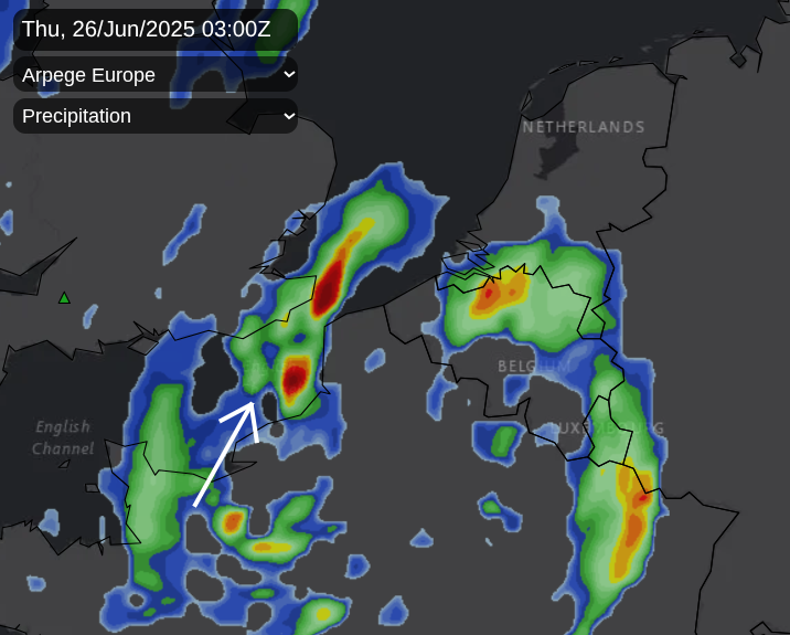
Some models show pulses reaching Kent just before midnight, others waiting until 4am. The Atlantic frontal band will be progressing from the west. So there is an easterly drift which will take any showers over SE Britain away over the North Sea by early on Thursday.
More chat and discussion in the Storms and Convective discussion - June 2025 thread
And also the weather in France. Will it Thunder? Dover is showing a 25% risk, Dungeness a 24% risk
Loading recent activity...


.jpg?w=1200)


