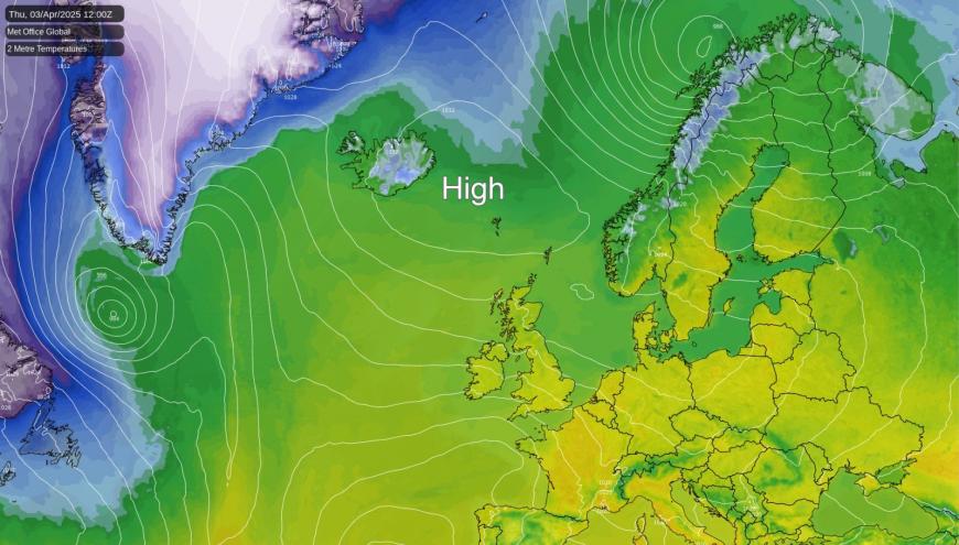
Settled weather looks set to continue across the UK for the rest of the week and into the weekend, thanks to a large area of high pressure, or anticyclone, positioned nearby. This high is effectively acting as a 'block', steering more active Atlantic weather systems away from our shores and maintaining generally dry conditions. Its position, however, is also setting up an easterly airflow across eastern parts, leading to a noticeable temperature contrast across the country.
 Blocking high pressure to keep the dry, settled conditions going through early April A combination of either Omega or Rex blocking high pressure near or over the UK will continue the prolonged dry and settled weather across most, if not all, of the UK through the first 7-10 days of April at least, if not through to mid-month. Netweather
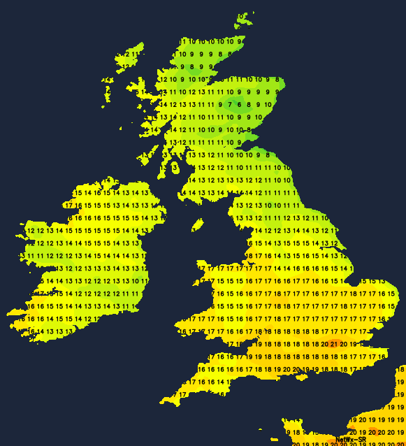
 Thursday sees the high pressure firmly in control, bringing dry conditions and spells of sunshine for many. Western and southern areas will see the best of the warmth, feeling pleasant where the sun gets to work. Temperatures here could reach well into the teens Celsius, maybe touching 19-20 Celsius in sheltered spots – well above average for early April.

It's a different story further east, though.An easterly breeze will pull in cooler air directly off the relatively cold North Sea, significantly holding temperatures back. Expect highs nearer 11 or 12 Celsius for eastern Scotland and northeast England, feeling much closer to, or even slightly below, the seasonal average here. While most places stay dry, watch for thickening cloud across parts of Wales and the southwest, which might produce a few isolated showers later on as a slight weakness in the high lets some moisture edge in.
The high pressure holds its ground on Friday, ensuring dry weather continues almost nationwide - although the threat of a shower or two in the southwest remains. The temperature split becomes even more pronounced. Western regions can expect another fine day with decent spells of sunshine, allowing temperatures to climb into the high teens, maybe 20-21 Celsius locally – still feeling unseasonably warm.

In contrast, eastern areas are likely to see more cloud drifting inland, fed by that persistent, chilly easterly breeze drawing air across the cool North Sea. This could lead to rather grey skies at times across eastern Scotland and much of eastern and central England. Temperatures here will struggle, perhaps only reaching 9 Celsius in some coastal spots, feeling decidedly chilly and below par for the time of year. Overnight, should winds ease under clearer skies, expect some mist and fog patches to form, particularly inland.
The weekend starts with the high still largely in charge, although perhaps beginning to adjust its position slightly. It'll be another mostly dry day with sunny spells, these again favouring western and southern parts. The overall temperature pattern persists: milder west and south, cooler north and east, but perhaps starting to edge closer to average values overall. Gardeners will have more dry weather, though the cooler temperatures in the east might continue to slow spring growth. Temperatures will ease back slightly, even in the south, with highs around into the mid-teens in London, possibly with more cloud developing. Parts of the northeast are likely to still feel noticeably cool, potentially only reaching 10 Celsius. The risk of overnight fog patches developing under clear spells remains as winds become lighter.
Rounding off the weekend, Sunday sees the high pressure still influencing things, so settled conditions generally continue. Expect dry weather with spells of sunshine once any early fog clears. The east-west temperature contrast is still present, although perhaps slightly less stark than earlier in the period as the easterly flow slackens a touch. Northeastern areas might see a slight lift, perhaps to 11 or 12 Celsius, while the south could be similar to Saturday, maybe 13 or 14 Celsius for maximums – much closer to typical early April values. Still pleasant enough for a walk where you find sunshine, but eastern areas stay on the cool side.
So, in summary, the 'blocking' high pressure means a largely dry and often bright end to the week and the weekend. The main feature remains the temperature difference driven by the wind direction – unseasonable warmth at times in western and southern sunshine, contrasting with a persistent chill for eastern areas exposed to the North Sea feed, especially earlier in the period. Keep an eye out for overnight fog and frost patches as winds ease.
Loading recent activity...