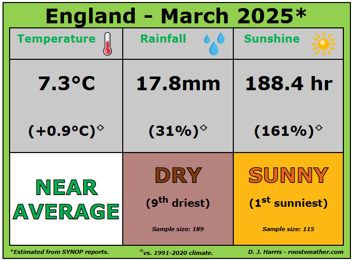
With just one day left, this March is looking like it could be the sunniest March on record for England, currently there’s been 188 hours of sunshine on average, some 166% above the 1991-2020 climate average. The current record for sunniest March stands at 171 hours, which was set in 1929. England sunshine records go back to 1910. Temperatures have been above average across the UK as a whole too,
 Source: Starling Roost Weather
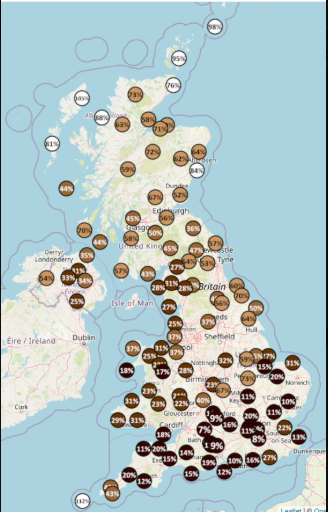
It’s also been unusually dry across large parts of England and Wales, only the Northern Isles, the Western Isles and Isles of Scilly have seen 100% average or above rainfall. Parts of southern England have been the driest, with St James Park in central London only recording 5% of the March average rainfall up to 29th, Lyneham in Wiltshire 6% and Kenley on the southern edge of London 7%. Large parts of England and Wales have seen less than 30% the March average.
 Source: Starling Roost Weather
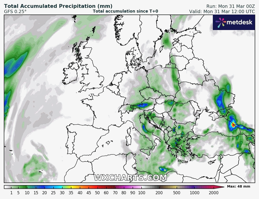
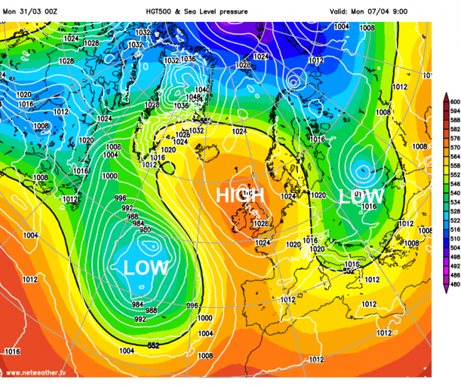
The outlook continues to remain dry for much of the country over the coming few weeks, perhaps for the first half of April, thanks to a persistent blocking high pressure system close to or over the British Isles. 00z GFS, below, shows most of the UK and the near continent dry as a bone for the 1st 10 days of April at least! More rain on the way for Iberia though this week - especially Portugal and western Spain.
The blocking high pressure system that’s currently bringing the prolonged dry and settled weather is typical of an Omega Block, which get their name because the upper air pattern looks like the Greek letter omega (Ω). Omega blocks are a combination of two cutoff lows with one blocking high sandwiched between them.
The Omega block close to or over the British Isles is sandwiched between two cut-off lows formed from two southward plunges of the jet stream. One cut-off low looks to persist or reform over the North Atlantic and another over eastern and southeastern Europe. In between is a ridge of high pressure, or a northward bulge in the jet stream, that's looks to remain in place over northern Europe, including the British Isles, that will ensure that low-pressure won’t be able to move north, with dry and settled weather locked-in for a while across the British Isles.
There are currently no signs of the blocking high status quo changing during the first half of April, with low pressure under the cut-off upper low over the North Atlantic drifting towards Iberia and perhaps affecting western France and further east over southern Europe too, but not any further north.
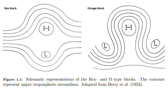
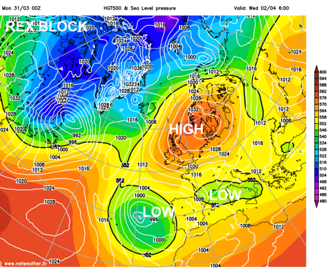
The Omega block will transition into a Rex Block and back again into an Omega block over the coming 7 days. A rex block occurs where a ridge of high pressure is located to the north of a low-pressure system. This looks to occur this week, as low pressure over the North Atlantic moving towards Iberia eventually extends east over the Mediterranean, bringing unsettled conditions further east across southern Europe. While warm and dry weather is kept locked-in across the British Isles.
There will be very little day-to-day change in the weather across much of the British Isles over the coming days, due to the blocking high. It will remain dry and settled over the UK, sunshine by day with temperatures generally above average, reaching the mid to high teens, highest temperature initially across the north, then highest temperatures across the south and west from Thursday, as a northeasterly breeze brings cooler conditions in the north and eastern coasts. A few spots could reach 20C.
It will be chilly at night though, thanks to dry air allowing temperatures to fall rapidly under clear skies at night. A slight ground frost is possible in places, perhaps an air frost in sheltered frost hollows. So gardeners beware ...
The blocking high could drift far enough west with time next week to perhaps allow colder arctic air to plunge south and southwest across northern and eastern Europe, perhaps as far west as northwest Europe too - but low confidence on much colder conditions reaching the British Isles. But for now, temperatures look to remain above average at least for the next 7 days, with no rainfall for many areas too.
Loading recent activity...