
This week, Spain has experienced deadly flash flooding. During the summer of 2024, central Europe was hit by terrible widespread flooding. Just over a year ago, Storm Babet hit the UK and Ireland causing seven deaths and some people are still not back in their homes.
“Climate change is causing more frequent, extreme, and unpredictable climate-related hazards.” WMO
What would you do if an Environment Agency Flood Warning appeared for your neighbourhood? If the UK Government Emergency Alert sounded on your mobile phone, announcing ‘Severe Flooding’? If, like the people of Valencia, you had to decide what to do and how to keep your family safe in a tense, dark, worsening situation.
The WMO (World Meteorological Organisation) has been working and campaigning for better flood forecasting and early warning systems around the world.
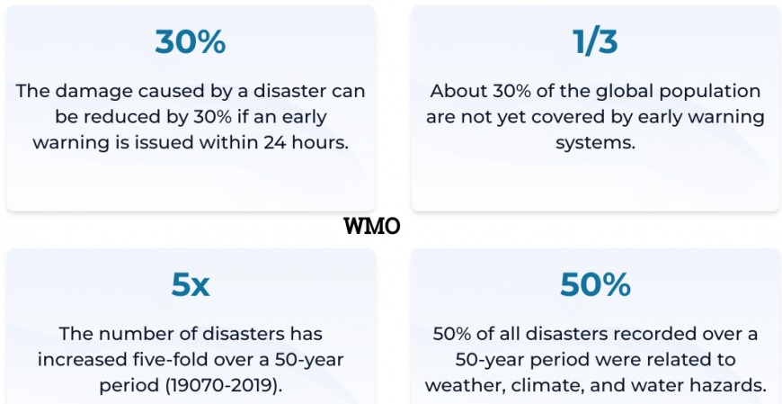
“Early warnings, issued within 24 hours of a hazard, can reduce the damage of that event by 30%. The number of disasters has increased five-fold over the past 50 years, and only half of the world’s countries have access to multi-hazard early warning systems.” WMO
We know that our climate is changing “Flooding, droughts, heatwaves and other climate-related hazards are becoming more intense, longer and more frequent.”
 What's caused the deadly floods in Spain this week? The Cold Drop or DANA low explained The threat of flash-flooding continues across parts of Spain on Friday, as a slow-moving upper low brings further areas of heavy rain and storms. This blog takes a look at the weather phenomenon behind the deadly flash-floods in Spain this week. Netweather
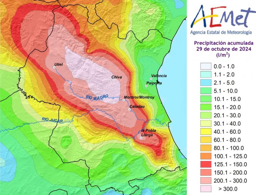
 Earlier this year in Valencia, weather discussion focused on drought and the lack of rain. In a violent shift, Valencia province and other parts of eastern and southern Spain were hit by torrential rain in the last week of October. This DANA event has resulted in devastating flooding and over 150 deaths. DANA (Depresión Aislada en Niveles Altos) is a synoptic setup with a cut-off upper low pressure and the potential to cause severe weather. AEMET (Spanish Met. Service) launched their first warnings about a DANA on the 24th October. By 07:42 on Tuesday 29th October, there were red rain warnings for Valencia province and there are still rain warnings on Friday 1st November in the region and a red one in the far southwest reaching into the Algarve in southern Portugal (IPMA). In the western Mediterranean, Majorca, Menorca and the Balearic Islands including Ibiza have amber rain warnings for the weekend. This has been an incredible event.
Stationary events cause big problems. That might be a summer time high pressure with heat building day on day, air pollution levels rising, and the unchanging situation leads to extreme heat and a deadly heatwave. Similarly, Atmospheric Rivers are frontal ribbons of rain which continue to feed onshore from mild, marine time sources for days on end.
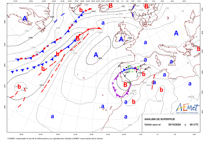
In a DANA setup, autumn cold air from the north is pulled around the low pressure as warm, moist air from the Mediterranean is pulled eastwards towards Iberia.
Gota Fría (Cold Drop) is an annual phenomenon where the first proper cold air from the north arrives over eastern Spain. It meets milder air and plenty of instability results. Heavy, thundery rain is set off along the coast. This results in localised flooding and disgruntled autumn tourists can be caught unawares in October or November.
This time, a cut-off upper low formed from a great meander in the jetstream and remained in place for over a week, anchored by a large high pressure over the UK. Our warming climate turbo boosts already severe weather events. The stationary setup of this DANA and the inland hills and mountains (the orography) caused lengthy deluges as thunderstorms and Mesoscale Convective Systems (MCS) developed. Annual rainfall totals fell in less than half a day in parts of Valencia province. The rain began to flow from the hills inland towards the sea, towards Valencia city and port. Jerez and Malaga also saw severe flooding.
The WMO explains that an early warning system is made up of four elements:
AEMET know about DANA, their weather models had analysed and forecast this setup. In the UK, the setup for Babet and other named storms, along with the widely adopted tri-colour warning system for severe weather, links into point 3 but it is not the responsibility of the National Weather Services alone.
“All four elements are equally important for reducing the impacts of extreme events. Each element applied alone or together with other elements, need to involve the participation of people and organisations at risk.” WMO
In Valencia, the warnings to specific people and communities didn’t come until after 8pm on the evening of the 29th. By then flood waters were flowing fast into the city. Here in the UK, when warned of flooding, there will be people who know to move their cars to higher ground, along the Thames, other rivers or by coastlines. And that’s what people did: they headed to basements and garages to move their cars and the roads instantly became gridlocked. People on ground floor homes or in hotels or nursing homes were also stuck. There hadn’t been time to prepare.
And that is where point 3 merges with point 4. After the forecast, who makes the decision that the situation will have significant impacts and where? While balancing the uncertainties in any forecast, what level of response is needed? How do we reach people (often older folk) who aren’t on social media?
It isn’t the responsibility of the UK Met. Office to decide that your local primary school should close for two days. The Met Office works closely with environmental agencies so that the rain warnings tally with the flood alerts and day-ahead flood forecasts. In extreme situations, there will be a COBR meeting (Cabinet Office Briefing Rooms), as the emergency services prepare and local authorities are informed to implement their severe weather policies.
Clear processes, good communications, and clarity around responsibilities are key.
@AEMETSE (trans.) ‘In the face of a DANA like this, there is something that can protect lives; people not leaving their homes. And that task does not fall to those who issue weather warnings, but to those who are in charge of safeguarding the well-being of the population ’.
Preparedness
If extreme weather events and severe flooding are more likely as our climate continues to change we all need to prepare and adapt. Investment and importance need to be given to adapting existing conurbations and the town planning of new housing and roads. In Brechin, the defences failed as the flood wall was not high enough for the event that unfolded. People and communities have to prepare. To consider where the weaknesses are, to create their own home flood plan and to know where reliable, quality information can be found if an event unfolds.
Look at your home insurance and if there are issues, contact FloodRe
Sign up for ‘Live Flood Alerts’ from your Environment Agency.
Think Local. You will know local, vulnerable areas that should be avoided in heavy rain but if you are on holiday or away for work, your risk increases without that knowledge.
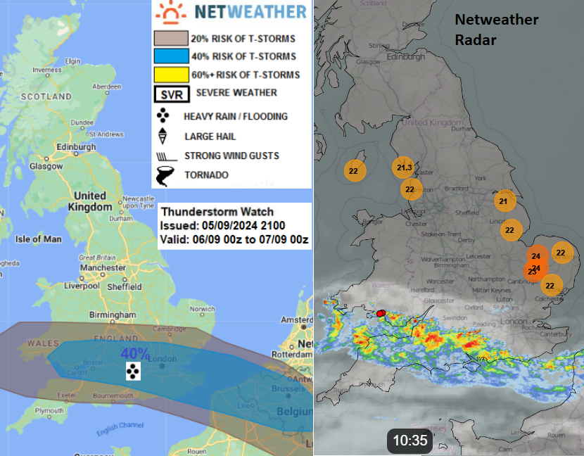
Netweather Radar. You will be able to see where the heavy rain has fallen in the past 15 minutes and if you choose the Animate button it will loop through recent rainfall. You can add on lightning strikes (Sferics) and zoom in. Within Netweather Extra, the rainfall update is quicker (5 mins) and you can view accumulated totals for the past 1 to 24 hours to see how much rain has already fallen that day.
Understand and be familiar with the Met Office weather warnings, which link impacts and likelihood, not just the amount of heavy rain or how strong winds will be.
Think about your own personal flood plan and talk to family and friends about theirs.
Political lobbying- your local councillors and Westminister politicians need to keep climate and environmental issues (including flooding) on their action lists. With so much going on in the world and at home, climate can sometimes be pushed away as a long-term issue. It isn’t. In Spain, thousands of people now don’t have power, transport, fuel or clean water. Jobs and schools will be inaccessible, and homes full of sludge and unsecured. Sanitation is disrupted and how to sort out the bundle of vehicles wedged down streets, potentially with more bodies? The months ahead will be hard, with winter on the way and the mental load of an event like this. The worry each time it rains, are you safe or will it happen again? Along with the financial hardship and logistical recovery.
The UK’s biggest food imports are fruit and vegetables. A good proportion of that comes from Spain particularly our salad and soft fruit at this time of year. That supply will be disrupted and that is what severe weather events do. The repercussions reach outwards and persist. Rivers, coasts, groundwater, reservoir or sewer, surface or flash flooding. Think about your own flood plan.
Loading recent activity...