
The risk of flash-flooding continues for coastal areas of northeast Spain on Saturday, with Amber warnings in force for flooding for Castellon and Tarragona, with further heavy downpours likely here.
Yesterday saw further areas of storms bringing flash-flooding across the far SW of Spain, with a red warning issued for Huevla province, and also the northeast of Spain and the Balearic Islands - where Amber warnings were issued.
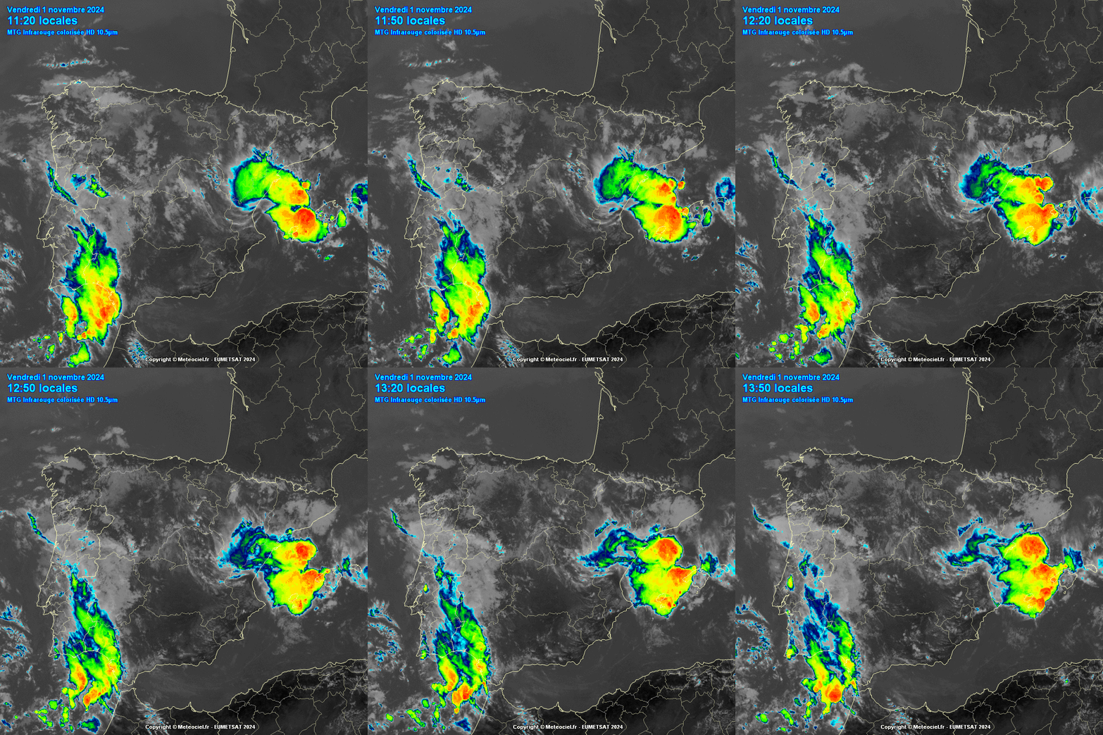
Thursday saw parts of Castellón province in northeast Spain to the northeast of Valencia hit by storms with several months’ worth of rain falling during the day over the area, leading to flash-flooding which damaged property and flooded streets with several feet of water. The village of Tirig in the area recorded 208mm of rain on Thursday.
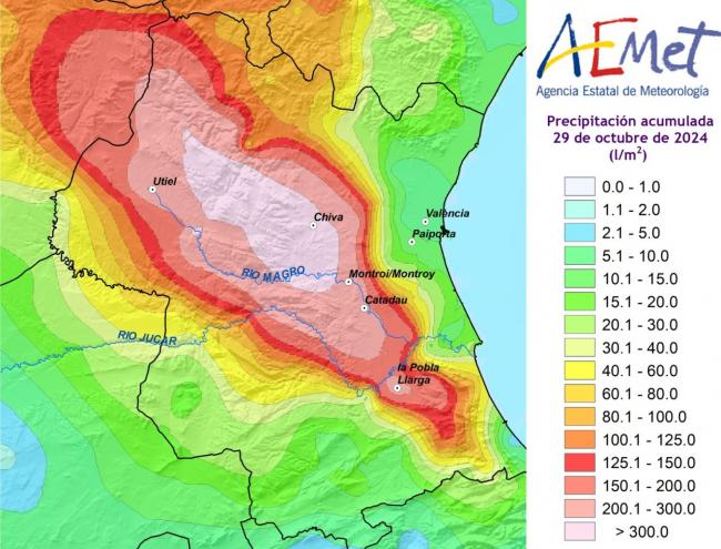
Rescue operations to look for people still unaccounted for and the clearing up of mud and debris continue in the Valencia area of eastern Spain badly impacted by extreme flash-floods that started on Tuesday, following up to 500mm of rain (around a year’s worth) falling in 8 hours to the west of the city. The official death toll still stands at 205, but the fear is - this will rise, with over 200 people still missing.
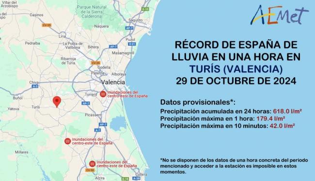
Provisionally new Spanish rainfall records were set at Turis in Valencia region on Tuesday, with 42mm falling in 10 miinutes, 179mm falling in an hour, and 618mm falling in 24 hours!
Because the heaviest rainfall on Tuesday didn’t fall across the city of Valencia but to the west and southwest over higher ground, people living in the city were likely taken by surprise by the sudden arrival of flash-floods sweeping through the city and surrounding communities – with a major river (Turia) flowing from the west passing south of the city – where extreme rainfall fell, causing much of the deadly flooding. However, there is criticism that the authorities should have alerted citizens of Valencia sooner of the impending floods. When alerts were finally sent to mobile phones it was already half-past 8pm on Tuesday, when it had been raining for two or three hours and it was already too late, as flash-floods entered the city.
The weather models were showing the potential for extreme rainfall in the area, particularly over the higher terrain inland, several days in advance. So, it wasn’t like it couldn’t be planned for in advance with the public warned in good time to stay indoors and go upstairs if they could.
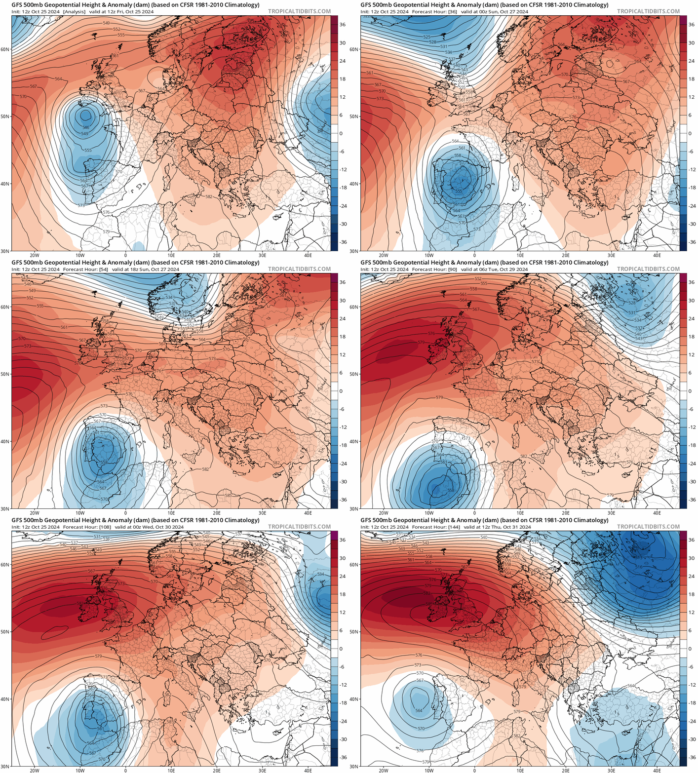
A common synoptic set-up for the occurrence of extreme rainfall along the east coast of Spain, as is the case this week, is the presence of an upper-tropospheric cut-off low (COL) or DANA (Isolated Depression at High Levels), a phenomenon that is also locally known as ‘gota fría’ (or ‘cold drop’), referring to the presence of cold air within the cut-off low. The upper low forms when an upper trough in the strong westerlies / jet stream over northern Europe disrupts and forms a closed low over SW Europe. Because it is cut-off from the jet stream, it becomes slow-moving and can loiter over one area for days.
At the surface, cut-off lows over Iberia often produce winds with an easterly component (known as the Levante wind) that blow inland from the warm Mediterranean Sea - pushing warm humid air upward over the mountains of eastern Spain, leading to orographic enhanced rainfall.
Such events can bring large rainfall totals to locations along the east coast of Spain -producing flash-flooding. The Mediterranean coast of Spain, and in particular the Valencia and Catalonia Regions are the most vulnerable to flash-flooding, and about one third of the most catastrophic floods in the region have been shown to be associated with cut-off lows or cold drops.
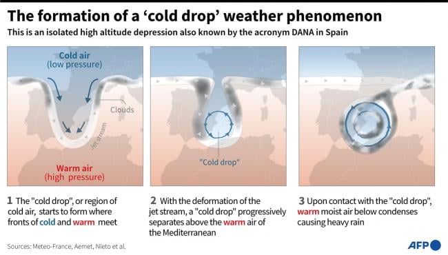
These cold drops are the main producer of extreme precipitation in the region of Valencia between September and November. Cold drops that produce extreme precipitation in this region generally remain stationary over Spain for 2 to 3 days and tend to produce precipitation towards Valencia for at least 2 consecutive days.
The slow-moving nature of a cold drop cut-off low can set the stage for devastating extreme rainfall events when it interacts with other favourable factors, like the warm waters of the Mediterranean Sea and nearby mountains. Because it is slow-moving, it can quickly pound areas with relentless rounds of heavy rain, resulting in significant flooding.
In September of 2019 a cold drop event flooded densely populated cities in the Valencia and Murcia regions, killing 6 people and forcing thousands to evacuate.
However, the deadly floods on Tuesday in the Valencia and Albacete areas of eastern Spain were more deadly than previous worst flood until Tuesday to hit Valencia back in 1957. The Valencia flood that occurred on 14 October 1957 resulted in significant damage to property and caused the deaths of at least 81 people. In response to the tragedy, the Spanish government sought to enact a plan to reroute the city's main river, the Turia, which lead to the deadly flood then. But this time, despite the rerouting of the river and improved defences, the city again saw catastrophic flooding with even higher death toll.
In a warmer climate, extreme precipitation linked to cold drops could increase by up to 88% in north-eastern Spain and 61% in the adjoining Mediterranean Sea according to a study.
Also, these cut-off lows, which are isolated from the jet stream further north over northern Europe, are likely to become more common due to climate change, which tends to produce more pronounced undulations in the jet stream – which leads to troughs disrupting into cut-off lows over SW Europe.
The rain should ease on Sunday and into the start of next week, though sub-tropical Storm Patty out over the Atlantic, just west of the Azores today, looks to move into Portugal from Tuesday, bringing outbreaks of rain or showers, that could bring some localised flooding here and parts of western Spain.
Loading recent activity...