It will turn noticeably colder this coming week across the UK following a warm and sunny first week of September for central and northern parts.
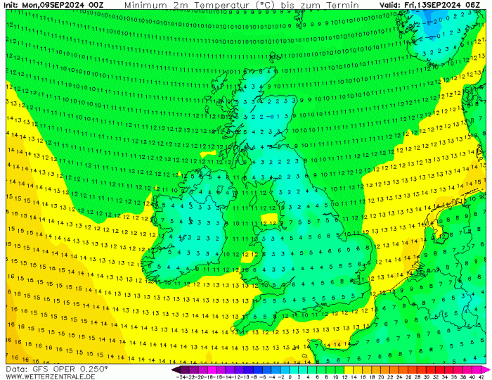
A northerly flow will bring arctic air south from mid-week, with temperatures struggling to reach higher than the mid-teens by Wednesday with blustery showers blown down by the cold northerly wind. There will be a chance of frost in parts of the north too.
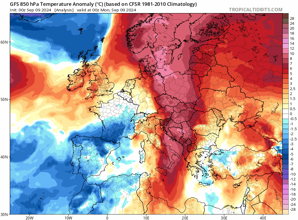
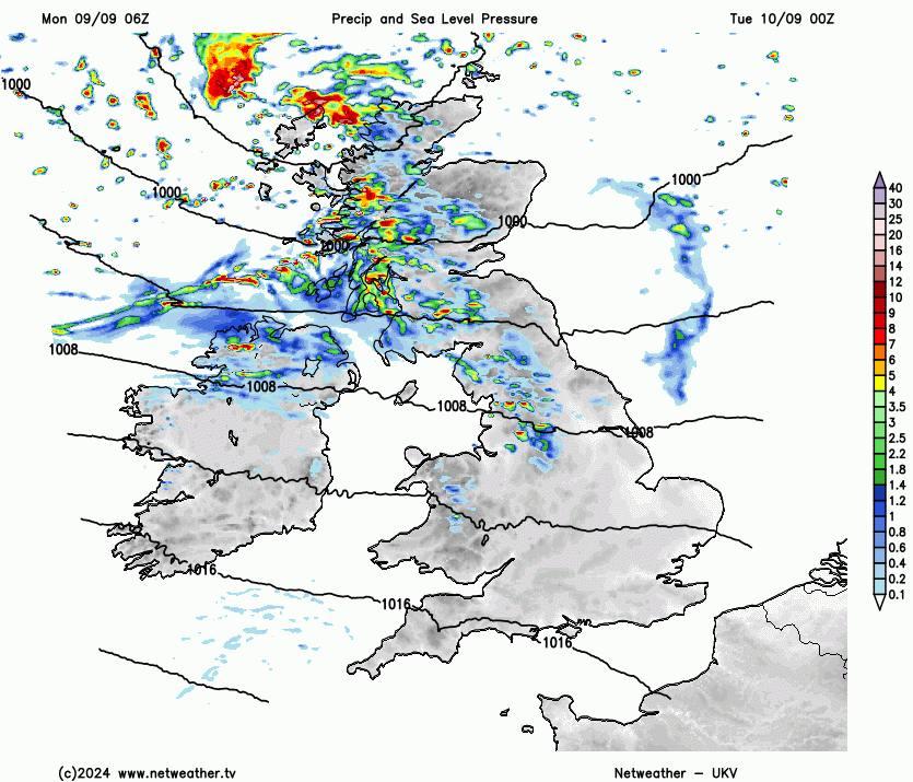
Following a dull and wet weekend across parts of England and Wales, with half a month's rainfall falling in places and around a month's worth of rain falling in 24 hours in Shropshire, it looks to turn drier and sunnier through the coming week for southern areas that have been cloudy for days and seen plenty of rain over the weekend. Western Scotland has seen the driest, sunniest and some of the warmest weather over recent days. But It will turn much cooler from the north across all parts through the week, so much so, that Wednesday and Thursday nights will turn chilly for all, with temperatures falling into low single figures widely, with a risk of frost in sheltered areas in the north. There will likely be some snow over Scottish mountain tops too.
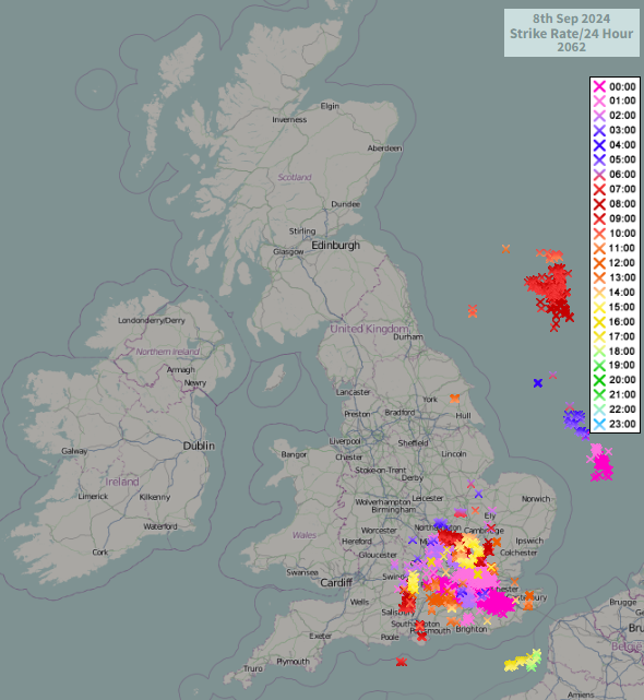
Southern areas saw over 2,000 lightning strikes during Sunday, as thunderstorms moved up from the south in the early hours, then further thunderstorms developed during the day. A persistent band of rain across western areas of England and east Wales dumped around a month's worth of rain in a day across parts of Shropshire, with Shawbury recording 69.2mm in 24 hours.
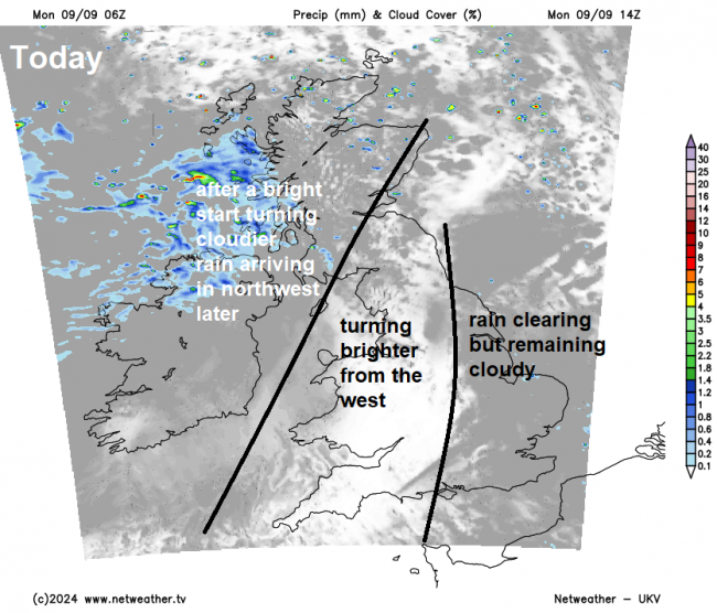
The storms have long gone, but the remnants of the rain band across the west yesterday are across eastern England this morning, bringing some mostly light rain. This rain should clear east and it will slowly brighten up from the west as the day progresses, though it may stay dull across eastern areas until the evening. More breezy and cooler than of late, temperatures reaching 18-19C across southern England, 14-17C elsewhere.
Turning wet and windy across Scotland and N. Ireland tonight, clearing to sunny spells and blustery showers on Tuesday, but turning colder too, gales in the far northeast exacerbating the cold feel. Further south, a band of showery rain clears south across England and Wales during the day, reaching southern areas in the afternoon - where it could turn heavy for a time, before clearing in the evening. Colder but showery conditions following across northern England and north Wales. A windy Tuesday for all, with westerly gusts of 30-40mph widely. Temperatures reaching 11-15C in the north, 15-18C in the south.
The colder arctic air from the north spreading down across all parts on Wednesday, which will be a cool and windy day, with sunny spells but also blustery showers spreading or developing south across many parts, though most frequent in the north and west. Temperatures reaching 11-15C at best.
After a chilly night, another cool and showery day on Thursday, sunny spells between the showers, though the wind should ease from the north, showers easing in the north too. With winds easing and skies clearing, Thursday night could be the coldest night of the week, with temperatures early Friday falling into low single figures widely, low enough to bring a touch of frost in sheltered areas in the north.
So a cold start to Friday, but with a ridge of high pressure looking to build in from the southwest, it looks like being a mostly dry and sunny day, though wind and rain may arrive in the far northwest in the evening.
Loading recent activity...