The recent weather pattern is expected to persist into the New Year, with the south experiencing mild and wet conditions, while Scotland maintains temperatures closer to the seasonal average.
The jet stream will slowly drift southwards and weaken, and there are strong signs that by next weekend, colder and drier weather will take hold, with high pressure developing over or just to the north-west of the British Isles. There is some uncertainty over the resulting weather pattern. Should high pressure dominate over Britain, most regions will experience dry and relatively cold conditions, with varying cloud coverage.
However, if the high pressure shifts to the northwest, as suggested by the latest ECMWF model projections, we might experience a significant influx of cold air from continental Europe through northeasterly winds. This shift could bring wintry showers from the North Sea, particularly affecting eastern England.
January is shaping up to be quite cold, especially if a sudden stratospheric warming event occurs. This phenomenon could strengthen the blocking anticyclones over and north of Britain, leading to more frequent northeasterly winds. Nonetheless, with global temperatures remaining at record highs, weather patterns that historically brought widespread lowland snow are now more marginal. Therefore, while there is a high likelihood of colder-than-average temperatures for at least a week or two, the probability of widespread snow is less certain. However, the chances of widespread snow around mid-January appear higher than in recent years.
Today, most areas will be cloudy. A band of rain will progress northwards through Scotland, following a dry, bright start in northeast Scotland, and will clear from southern Scotland by afternoon and evening. This will result in snowfall on higher terrain, particularly in the Scottish Highlands. Another band of rain will traverse Wales, northern, and western England. This band could bring a pronounced squall line, characterized by strong winds and heavy rain, moving eastwards across England and Wales. East Anglia and southeast England are likely to remain mostly dry, albeit cloudy. Weather conditions will improve in Northern Ireland, with some scattered showers, primarily in the west.
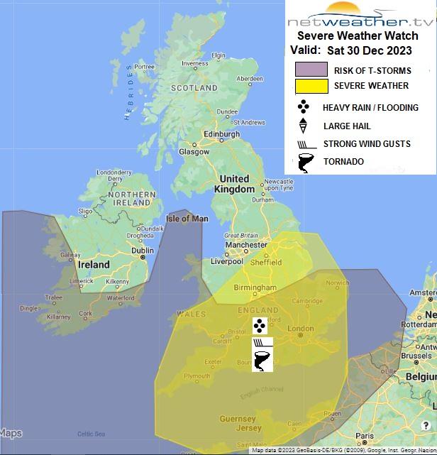
A severe convective watch has been issued for today.
Temperatures are expected to be unseasonably mild in Wales and the southern two-thirds of England, reaching 10-12°C. In Northern Ireland and northern England, temperatures will range from 7-9°C. The northern half of Scotland will see temperatures of only 4-6°C at lower elevations, with near-freezing temperatures on higher ground, where precipitation will primarily be snow.
On Sunday, the persistent rain will recede northeast overnight, paving the way for a day of sunshine and showers, accompanied by blustery southwesterly winds in southern Britain. Showers will spread across most areas, although sheltered eastern regions may see fewer, and parts of northern Scotland could remain dry. There's a possibility of showers merging into longer periods of rain in northwest England and north and west Wales during the afternoon and evening. Showers will mostly fall as rain, but as sleet and snow on higher ground in Scotland and northern England. Temperatures will peak at 6-9°C, aligning with typical values for this time of year.
The blend of sunshine and showers will extend into New Year's Day, with diminishing winds. Temperatures will be slightly lower than on New Year's Eve, allowing showers to become more wintry in the north, though any snow accumulation will be limited to higher elevations. Showers are expected to taper off as the day progresses. On Tuesday, 2 January, another band of rain will sweep across England and Wales, reaching Northern Ireland and southern Scotland, while northern Scotland remains bright with scattered showers. As winds shift to an easterly direction in northern Scotland, showers will become more prevalent in eastern regions.
From 3 to 5 January, we anticipate more sunshine and showers, mainly in Scotland, with England and Wales experiencing more persistent rain, particularly in the south. Showers in Scotland are likely to turn increasingly wintry, with snow accumulation becoming more common on higher ground. Beyond this point, there's uncertainty regarding whether conditions will be predominantly cold and dry or cold and snowy. However, the likelihood of a cold turn remains high.
Loading recent activity...