You have probably seen a plethora of articles growing on social media over the last few days about a Sudden Stratospheric Warming (SSW) event over the coming week bringing the Beast from the East, like that occurred in late February / early March 2018 which was triggered by an SSW earlier in February that year.
A Sudden Stratospheric Warming (SSW) occurs when the usual westerly flow over the arctic is disrupted by large-scale atmosphere waves (called Rossby waves) in the troposphere which get pushed higher into the atmosphere. These waves can “break” (like waves in the ocean) on top of the polar vortex and weaken it. If waves are strong enough, the winds of the polar vortex can weaken so much that they can reverse from being westerly to easterly. This leads to cold air descending and warming rapidly, with a sudden jump in temperature.
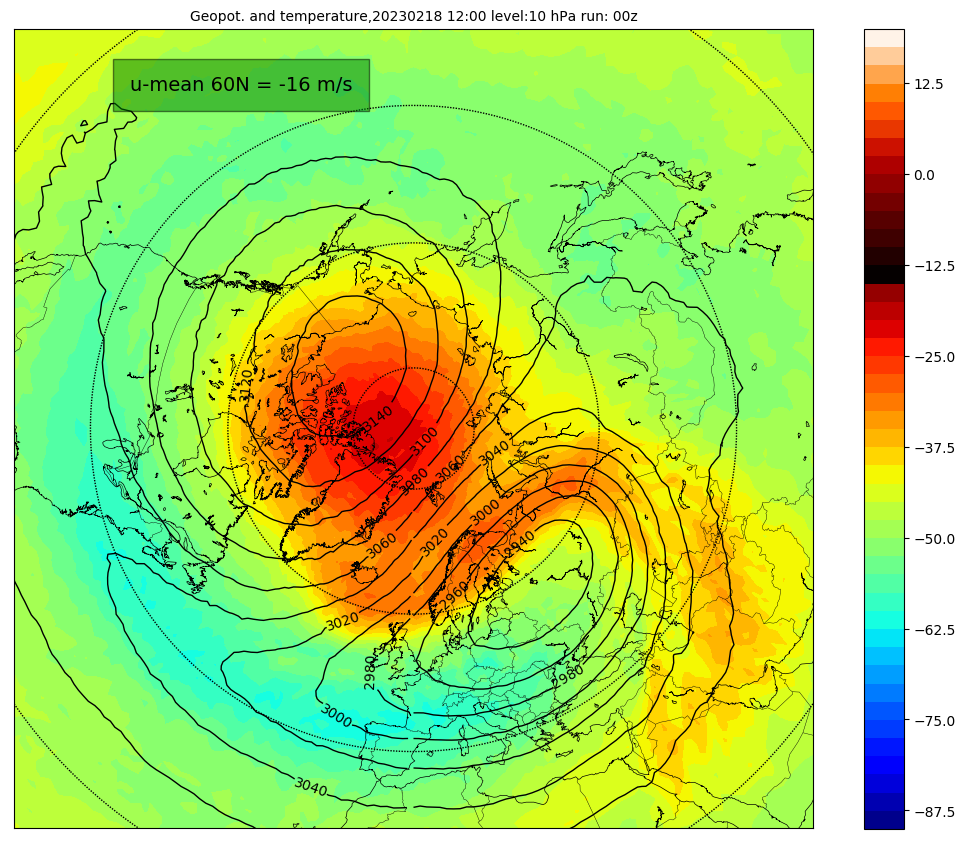
Models are forecasting a displaced stratospheric polar vortex next week,similar to the position below

Although a Sudden Stratospheric Warming refers to a rapid warming (in extreme cases as much as 50°C in just a couple of days) in the polar stratosphere, between 10 km and 50 km up, a major SSW is often defined as a wintertime event in which the zonal (westerly) mean wind at 60N and 10 hPa reaches zero and turns easterly.
Following an SSW, the disrupted vortex in the stratosphere can couple with the troposphere (where our weather happens, with the easterly winds propagating downwards to the earth’s surface leading to a weakening of the polar jet stream leading to high latitude blocking high pressure and lower pressure over mid-latitudes, mirroring the stratosphere. This can lead to extreme winter weather, such as the extreme cold snap in late February / early March 2018, as cold air bottled up over the arctic escapes and causes cold air outbreaks over parts of Europe, parts of Asia, and the USA.
However, the downward propagation of the reversal of zonal winds and coupling of the stratosphere with the troposphere can take weeks or even months and impacts at the surface are not guaranteed and they are not necessarily experienced everywhere.
A major SSW in Feb 2018 occured, the reversal of winds (blue) can be seen mid Feb 2018 between 60N and 90N, with quick propagation downwards to the troposphere:
A major sudden stratospheric warming is now underway, with a reversal of winds from westerly to easterly above 10 hPa (zonal winds falling below 0 m/s) forecast around the 15th February by most weather models that simulate the stratosphere.


GFS actually shows 2 warmings in the space of about 10 days after the 15th, both are accompanied below the stratosphere by a burst of westerly winds flushed down into the troposphere by the reversal of easterly winds higher up, but no sign of these easterly winds reaching troposphere to bring high latitude blocking and thus a greater risk of colder weather with risk of snow. Certainly not for the rest of this month at least.
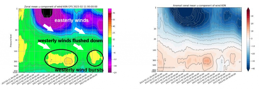
But GFS does show a sustained reversal in top of the stratosphere, thanks to the 2nd warming impact preventing the polar vortex from reforming towards the pole. The sustained reversal high up in the stratosphere slowly trickling down through the stratosphere towards the end of February. This suggests that the reversal, if it continues downwelling, may reach down to the troposphere, where our weather happens, eventually.

So, there is no Beast from the East with snow and ice indicated in the model output out to 16 days, for now at least, so probably not for the rest of this month. But we will be monitoring the downwelling of the reversal to see if it reaches the troposphere, but based on current GFS forecast analysis of the atmospheric winds, I wouldn't expect any impacts of next week’s SSW event until early March if the reversal reaches the troposphere.
It needs to be stressed that not all SSWs lead to cold and wintry weather. Every SSW is different and around 66% of them lead to colder conditions, so not all SSW events lead to cold. For example, the SSW in February 2018 led to the ‘beast from the east’ later that month and into early March, whereas the SSW in January 2019 had no significant impact for the UK and NW Europe, due to the easterly winds in the stratosphere not propagating down into the troposphere. In fact, it stayed mild for the rest of the winter.
One other driver that may also bring winter’s revenge to end this month, other than the SSW, is the Madden Julian Oscillation (MJO). This an area of active and enhanced tropical convection moving over the tropics and can effect the weather patterns of N America and Europe. There are 8 phases of the MJO and phases 7-8-1 are when it most moves over the tropical western Pacific and its here that tends to lead to poleward wave propagation which can have an impact on the polar vortex and also can lead to a negative North Atlantic Oscillation – which is an indicator of blocking high pressure over Iceland / Greenland and low pressure over SW Europe or Azores associated with cold and wintry weather over northern Europe.

The current model MJO forecasts take it through phase 7 over the coming week or so. There is a lag of around 7-10 days before there is an impact on the upper patterns over mid-latitudes with the resultant increased likelihood of high-latitude blocking, bringing the risk of colder weather for the UK by the end of the month. This perhaps occurring before any impacts of the SSW / wind reversal moving down from the stratosphere and imprinting on the weather patterns too.
So, in a nutshell, given the potential double-whammy of SSW and MJO impacts, a heightened chance of winter’s revenge as meteorological winter ends and spring starts, with cold and snow. But as ever, with UK being a small island, nothing is guaranteed.
Loading recent activity...