What a start. Sunshine, heat and fine dry weather for Glastonbury. It won't last. The risk of heavy downpours on Thursday afternoon and then a fresher feel to end the week with scattered showers.
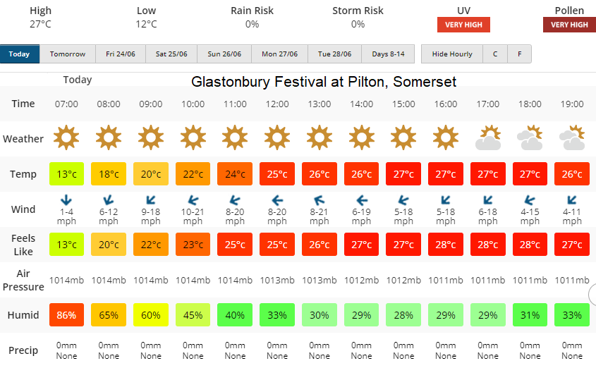
A glorious sunny and very warm start for Glastonbury today which will please those pitching their tents today. Sunscreen, sun hats and plenty of fluids will be the order of the day. However, it isn’t going to stay like this. Today 28C and full sunshine.
Click for other days
Thursday starts off on a similar note but a cluster of heavy showers is forecast to move up from France over SW Britain on Thursday afternoon and will affect Somerset. It could be that the worst of the downpours misses Worthy Farm and festival-goers just see darkening skies and rain in the distance. Or the heavy showers do move through for a time tomorrow afternoon and then clear. The problem here is that they could include thundery showers with hail and lightning. There will be a plume from the south but also the risk of isolated surface-based storms developing. That will depend on the daytime heating. There will be more cloud about but still, the chance that the temperatures will leap up in any sunny spells and the convection will really get going. The ingredients are there.
Thursday 22C to 25C with sunny spells and a light east wind. The risk of sudden torrential downpours with hail, high gusts and lightning.
You could watch the progress of the showers or storms on the Netweather Radar. Use the animation button to see the movement of any rain and make sure the Lightning button is On to show any sferics (lightning strikes).
There is low confidence in this part of the forecast, so using the Netweather radar will at least allow you to see where the showers are moving (they may be further east or west) if you add in a postcode marker. Advertised as BA6 9XE from Wales or northwest. BA4 4LY from Swindon or local traffic to follow Glasto signage
.png)
Into Thursday evening the feed of showers does continue from the south but there looks to be a drift eastwards which should take them away from Pilton.
A quieter cloudy start on Friday with a fresher feel to things. Low pressure will be moving near to the UK and around this, there will be a feed of blustery showers for the West Country. It will feel warm in any sunny spells, but showers are likely by the afternoon. They come, they go and it will feel cooler by Friday evening. 20C bright spells with showers and a moderate SW wind.
A similar story with strong, warm sunny spells with the risk of showers. Saturday will see a breeze but feel warm at 21C whereas the air looks cooler by Sunday and only up to the high teens. It will be cool after dark and overnight, don’t be fooled by this high summer first day. Have a great time.