One part of Glastonbury 2022 is looking dry, very warm and sunny. The other part will see showers and feel much cooler with more cloud and a breeze. Pack a sun hat and a woolly hat.
Some clarity now for Wednesday and Thursday and it shows sunshine and warmth midweek before a change. High pressure extending in from the Atlantic will manage to keep the fine, dry weather over southern Britain as temperatures increase midweek. Next weekend looks more unsettled and cooler again.
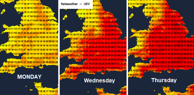
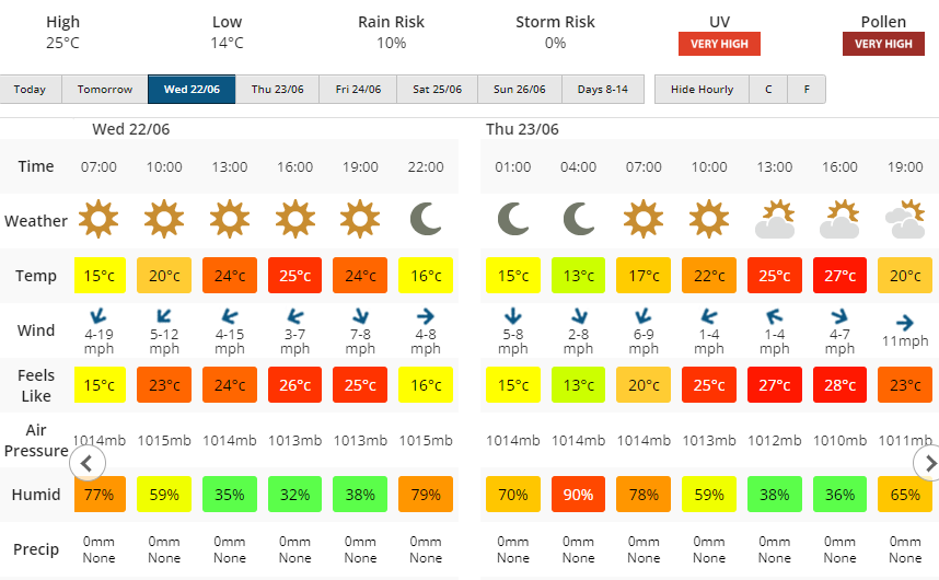
For those heading off midweek you will be pitching tents in dry weather with hardly any breeze. Strong sunshine though with high UV values and high pollen. The temperatures creep up each day with warmer air over Somerset. Wednesday should be 25C in brilliant sunshine and Thursday 27C although with a bit more cloud. The temperatures do fall away overnight and in the late evening down to 10 to 13C but by day it will feel very warm.
There will be a change later this week. It would be a bit much to expect wall to wall sunshine for the whole of Glastonbury. The weekend looks more unsettled and cooler with Friday being a transition day.
If you were looking purely at the symbols display Weds /most of Thurs is simple with sunshine by day or clear skies by night. Very light winds and warmth, temperatures back up into the high twenties and it stays dry. Increasing high cloud later on Thursday, well ahead of the incoming frontal band, will be linked to instability over northern France. This could result in some late afternoon or evening heavy showers for Somerset. However, confidence is low about this. This before the main cold front which will bring rain and the change for end the week. The shower threat looks to continue for southern Britain during Thursday night.

Should see a fine start as any overnight cloud and any showers shift eastwards over England and then we wait to see how the incoming cold front proceeds
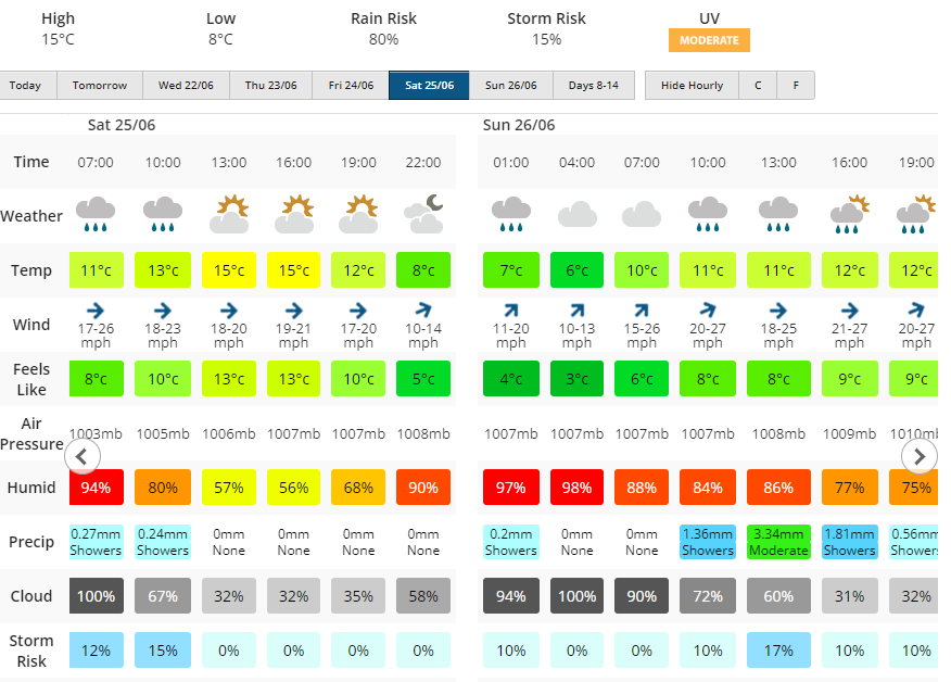
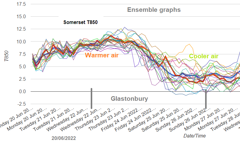
Looking ahead to the weekend, don’t take the timings too literally this far ahead. Certainly, don’t be matching wet and dry times to sets on stage. Look at the overall picture. It is much cooler, almost nippy by night. There is a westerly breeze, more cloud, outbreaks of rain and all of this will add to the fresher air. It will have been all very well setting off on Wednesday with that summery outfit in the sunshine but Saturday evening you’ll be wanting your jumper. And maybe a cosy hat.
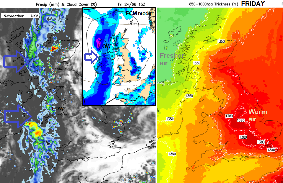
The main area of uncertainty is around the showers and potential thunderstorms on Friday, perhaps evening Thursday evening. There are lots of areas of input in this picture. Homegrown showers, even storms in the heat ahead of the front. Imported showers from the south and embedded thundery downpours along the front. There is a leaning towards the southeast and east of Britain for most of the heavy showers so some hope that it will just be the odd shower for Glastonbury rather than a succession of hefty downpours. That would keep the risk of Mudfest conditions down and power outages.
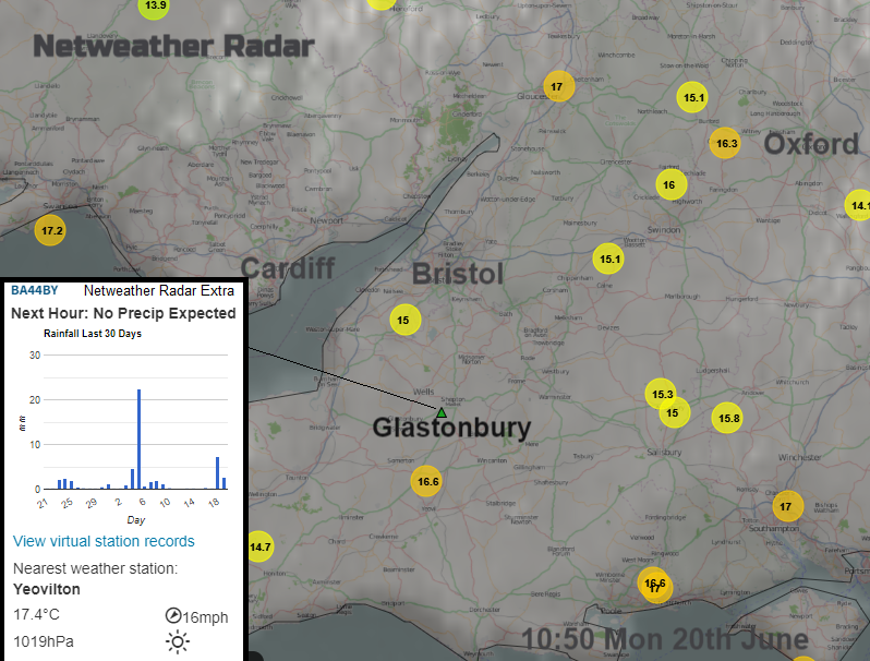
Check out Netweather Radar Extra to view current conditions and where any showers or rain bands are. And how long you have until a downpour arrives.
Later on Friday, in the fresher air, any showers will just be feeding in from the west on the cooler westerly breeze. Coming and going, then back to warm sunny spells. Low pressure looks to just rotate about over Scotland bringing a 'bright spells with scattered showers' setup for the rest of the weekend to Glastonbury.
More discussion and chat in the Netweather forum about the Glastonbury forecast
Top Photo by Annie Spratt on Unsplash