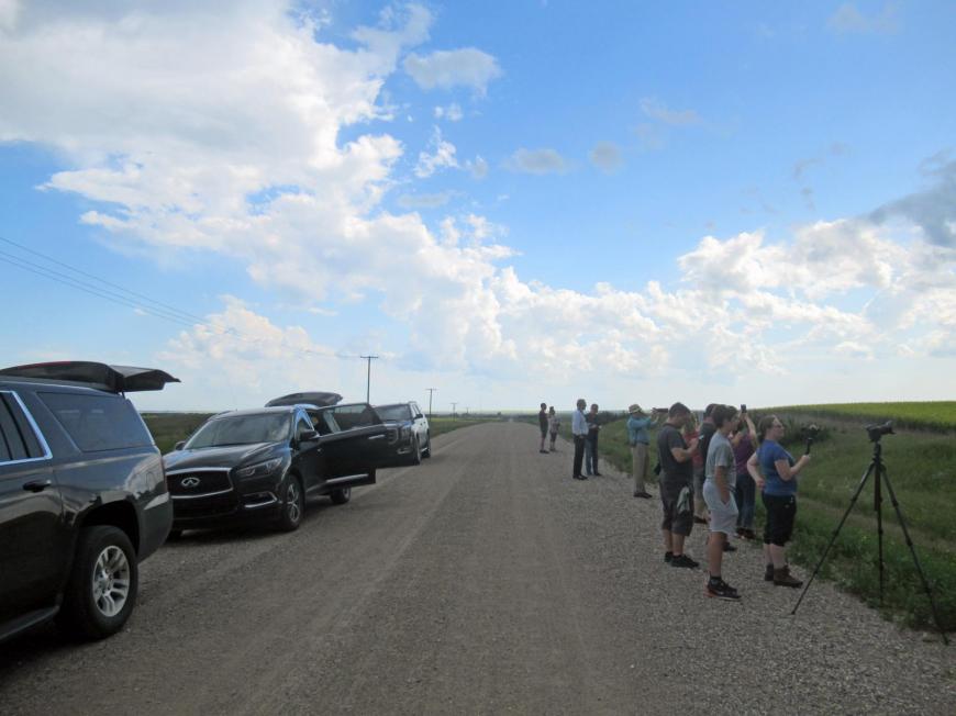
After a hiatus of three years, the Netweather Weather Holidays tours are back on the road. Early May into mid-June is the season for most visits as it is usually the most active time in the open central region of the USA.
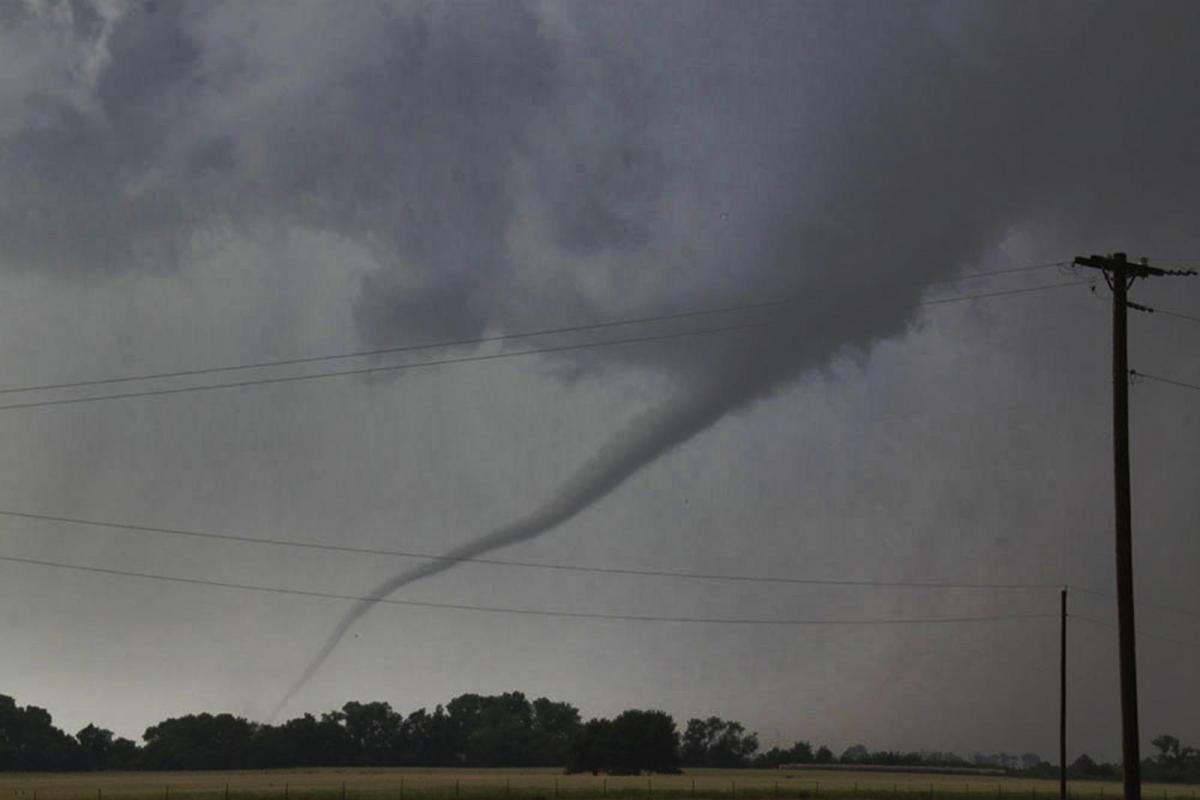
The centre of the US is an area of Great Plains where many tornadoes appear. This region is known as Tornado Alley. If you looked at the US and took a swathe up through the middle, maybe a touch to the west, that would be Tornado Alley. Texas, Oklahoma, Kansas, Nebraska and South Dakota with a sliver of eastern New Mexico and eastern Colorado.
This nickname was started in the 1950s. In some years other factors influence the patterns and severity of a season and there is chat about a drift eastwards of perhaps the most active storms and tornadoes.
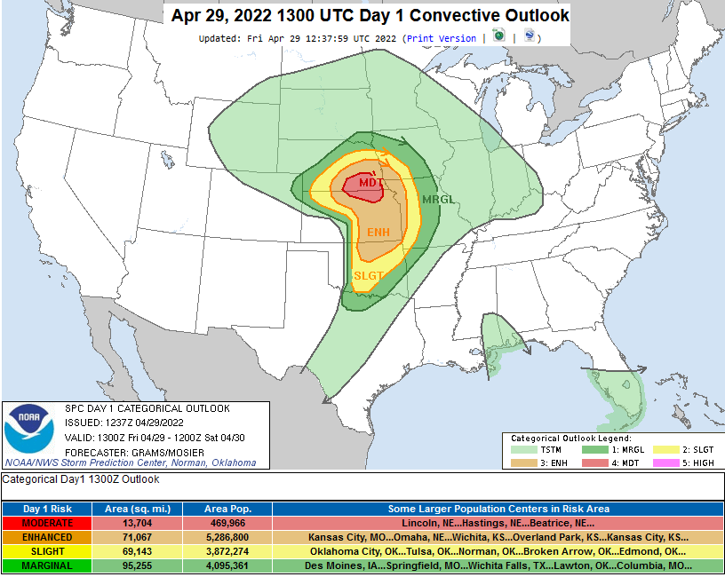
.THERE IS A MODERATE RISK OF SEVERE THUNDERSTORMS SOUTH-CENTRAL & SOUTHEAST NE TO NORTH-CENTRAL AND NORTHEAST KS...
...SUMMARY... 29th April 2022 A multi-outcome severe weather episode is forecast this afternoon into tonight across the central Great Plains vicinity. Conditionally, the threat for significant severe weather intensities is apparent which includes destructive wind and hail, along with a few strong tornadoes.
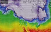
The western side borders the Rockies and the Plains fill with warm, humid air from the Caribbean Sea to the Gulf of Mexico. Dry air from desert region of the southwest meets dense, colder dry mountain air from the north.
“Meanwhile, cool dry air arriving from the west of the Plains originating from the Rocky Mountains or hot dry air arriving from the Desert Southwest forms what is known as the “dryline.” The air on the west side resembles scorched desert air. On the east side of the dryline exists warm and humid air.
The cold/warm frontal boundary between polar air moving south and tropical air moving north can dissect the dryline forming what’s known as a triple point. This normally forms with an area of low pressure developing in the lee of the Rockies and moving out across the Plains.” Nick Finnis
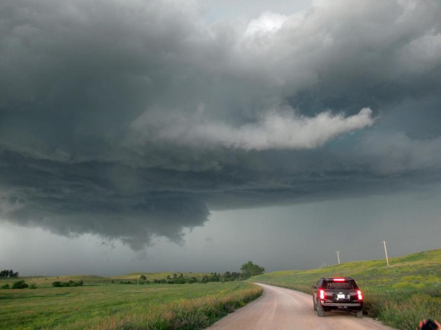
With daytime heating, there is convective lift, up go the clouds and sometimes storms appear, and the chase is on. It’s a balance and a waiting game for the right ingredients, right conditions and either good luck or judgement, maybe a bit of both.
A second tornado alley was named in the early 70s where increased, often violent tornado activity occurs. This is called Dixie Alley and covers some southern States. Eastern Texas through to Alabama. Some view it as just an extension of the central, original, Tornado Alley. A shift eastwards even a change of focus.
This region covers the lower Mississippi Valley. It spans from eastern Texas and Arkansas across Louisiana (tri-state area Ark-La-Tex), Mississippi, Tennessee, Alabama, Georgia, western South Carolina and western North Carolina. Lots of people live in this region and the tornadoes here can be strong and long tracked so events attract news coverage and peak much later in the year.
Some say that any discussion around this southern area becoming more active than central Tornado Alley might just be linked to observations and imagery. That the open Plains give great visibility across the flat lands to spot storms. The more wooded areas to SE might have historically obscured some events in decades past. Or that with more moisture, thestorms are likely to be part or fully rain-wrapped and so not seen.
I asked Weather Holidays Chase Lead, Paul Botten about any possible shift in tornado action in the US.
“There is definitely a seasonal shift still and you can see that with this year in what is a typical season so far. Lots of tornadoes in the Mississippi and Ohio River valleys in Feb and March shifting West to Arklatex in April and we are now seeing much more in the way of risks in traditional Alley late April and going forward into May.
What we do have is bigger capping concerns over the Great Plains due to the drought, but this is sometimes better for isolated Supercells and non-messy storm modes. It's easier to convect further east but they get a lot more QLCS* tornadoes. Some of the bigger stronger Tornadoes since 2013 have also occurred further east which has made the news as well. So, the jury is out for me, and I still think both have merits on being as dangerous and deadly as each other. It hasn't helped to have two La Ninas straight after each other. If they get two El Nino winters, which favours flooding rains over the Plains in the winter, then things could change quite quickly.” Paul
*QLCS – Quasi Linear Convective System, a squall line or family of storms moving together as one line.
Paul is now preparing for the upcoming 5 tours which run from early May until early July, excited to get out on the open road once more with the team of drivers and tour group. We look forward to updates and chat in the Netweather forum.
Loading recent activity...