Meteorologists started chasing storms in the name of science many decades ago but storm chasing as a hobby and tourism industry is still quite young. The first storm chasing companies started in the mid 90s, when GPS and weather data become more widely accessible and today there are many tour companies offering organized tours for groups.
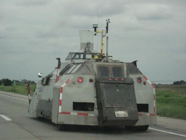
The whole idea about storm chasing is to find severe storms and experience the beauty and power they possess, I guess the ultimate goal is to see a tornado, but at a safe distance. The goal is not to get into the storms really, but rather stay at a safe distance observing them. Though there are extreme chasers that do get close or actually go into tornadoes, usually for scientific purposes, with vehicles that have been specifically designed to withstand tornadoes, up to a certain strength, such as the Tornado Intercept Vehicle (TIV).
Severe thunderstorms producing large hail, damaging winds and even tornadoes can occur all over the world. Although some organised storm chase tours occur in Australia and Canada, for most who want to experience these powerful storms by chasing them, the best place to go is the plains of central U.S.A from late April through to mid-June.
Tornado Alley
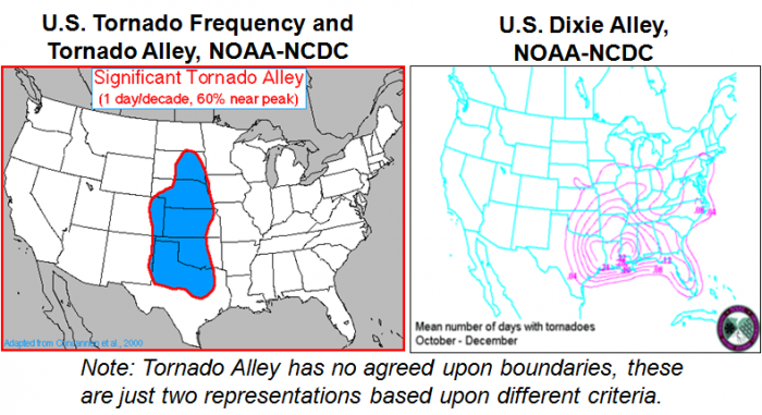
An area of the plains, nicknamed ‘Tornado Alley’ is where there is the greatest potential for tornadoes, usually between April and June. Although the boundaries of Tornado Alley are debatable, the region from central Texas, northward to northern Iowa, and from central Kansas and Nebraska east to western Ohio is often collectively known as Tornado Alley. This is usually where most of the organised tours and also DIY chasers from abroad plan to start their ‘chasecations’ each year.
There is also a second tornado alley where there is increased tornado activity, dubbed ‘Dixie Alley’ and extends from eastern Texas eastward through Alabama. Tornadoes here tend to reach a peak frequency from October through December. Florida also has numerous tornadoes due to the high frequency of thunderstorms throughout the year. However, Dixie Alley and Florida have the disadvantage being heavily wooded over large parts.
There are good reasons why storm chasers from all over Europe flock to the central U.S.A each spring and early summer, rather than stay at home, because:
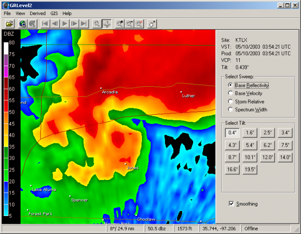
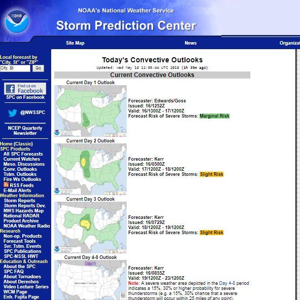
5. Forecasts – the forecasting of severe thunderstorms in the U.S.A, led by the U.S. National Weather Service’s Storm Prediction Center (SPC), is second to none. The SPC provide detailed Day 1, 2 and 3 forecasts for severe thunderstorms across the continuous U.S.A, the day 1 forecast will detail and delineate on maps the risk of tornadoes, wind damage and large hail. They also do a day 4 to 8 forecast. They also provide watches or warnings for severe storms and tornadoes. The watches cover a larger area than the warnings, usually covering several counties in a state and sometimes areas of more than one state. Severe thunderstorm or tornado warnings will cover an area likely to be impacted by an ongoing severe storm. These watches or warning can be found on the SPC website or their twitter feeds, also they are transmitted via messages which interrupt normal broadcasting on local radio. A weather radio, which can be picked up in most U.S. supermarkets, is a more old-fashioned way to receive this information, but just as valid.There are also forecasts given out by professional meteorologists and chasers on U.S. weather forums and social media outlets such as twitter or facebook in particular.
The answer is both yes and no. If you go with an experienced tour group and take note of their instructions and thus take the necessary precautions whilst chasing severe storms, then generally it is not dangerous.
Quite often, the risks of storm chasing can often be unrelated to the storms themselves. The tornadoes do not pose the greatest risk but rather common, and less spectacular, risks like traffic accidents could be more dangerous.
Tornadoes are the most dangerous part of a storm cloud and getting close or into one can land you in big trouble, even a few experienced chasers have been caught by surprise and been killed by them, such as the El-Reno tornado in 2013.
But they are not the most dangerous threat during a storm chase! Tornadoes are quite rare and are only harmful in a limited area. Lightning and hail is, compared to tornadoes, a greater risk for storm chasers. Lightning could kill or severely hurt you and large hail could get hurt if caught out in it. Baseball sized hail and strong side-winds can smash a car window causing exposure to hail and cut wounds from the glass. Getting hurt even by lightning or hail is, however, very uncommon and by taking normal precautions.
The Great Plains exist on the southern end of the North American continent that stretches from the Arctic to the Tropics. The large landmass acts as highway that transports dense polar air southward. With no southern mountain range, it also allows warm and humid air from the Gulf of Mexico and Caribbean Sea, uniquely situated to the southeast of the Plains, to proceed unimpeded towards the advancing cold air to form a frontal boundary that can trigger severe thunderstorms.
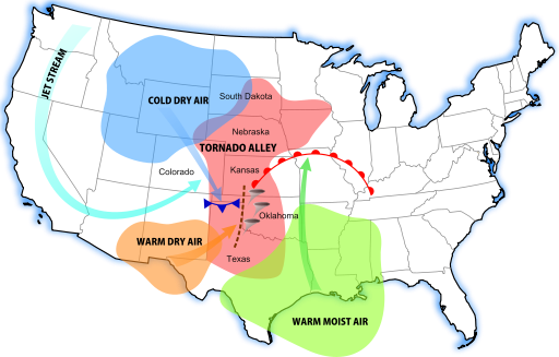
Meanwhile, cool dry air arriving from the west of the Plains originating from the Rocky Mountains or hot dry air arriving from the Desert Southwest forms what is known as the “dryline.” The air on the west side resembles scorched desert air. On the east side of the dryline exists warm and humid air. By laws of physics, the hot dry air is denser than the warm moist air, so forces the moist air upwards into towering cumulonimbus clouds that can reach 60k feet.
The cold/warm frontal boundary between polar air moving south and tropical air moving north can dissect the dryline forming what’s known as a triple point. This normally forms with an area of low pressure developing in the lee of the Rockies and moving out across the Plains.
This sometimes dramatic collision of differing airmasses can cause the storms to reach high into the sky (up to 60,000 feet), making it easier for a storm to access increasingly fast jet stream winds. The westerly jet stream winds override the southeasterly surface winds flowing into the Great Plains. The increased wind speeds and directional changes create an invisible, horizontal spin that affects storms.
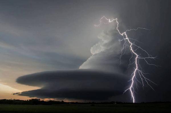
The storm’s energetically rising air tilts the horizontal spin into a vertical direction, thus giving rise to a rotating thunderstorm, known as a supercell.
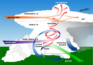
The rotating updrafts in these supercell storms can reach speeds as much as 100mph or more, which can allow hailstones that form to be suspended and grow to large diameters, as big as a baseball. The rotating updraft can also form a ‘mesocyclone’, a storm-scale region of rotation, typically around 2-6 miles in diameter and often found in the right rear flank of a supercell (or often on the eastern, or front, flank of an High Precipitation storm). The circulation of a mesocyclone covers an area much larger than the tornado that may develop within it.
A number of atmospheric conditions need to exist at the same time to produce the intensity of thunderstorms that spawn tornadoes: abundant low-level moisture, atmospheric instability, and a mechanism to “lift” the air" such as a cold front or dryline, and strong winds aloft winds that turn with height in a clockwise, or veering, direction. This turning of wind direction with height is called vertical directional wind shear. Wind speeds increasing or decreasing rapidly with height is called vertical speed wind shear.
Long hours on the road – sometimes a chaser may be sat in a chase vehicle for long hours, sometimes up to 10 hours or more, when getting into position then actually following storms, so if long journeys are not for you, then chasing storms may be a struggle. Sometimes storms may not get going until early evening, then you may be chasing them well into the evening. Dinner and check in to the hotel for the overnight stay may sometimes be late evening on hectic chase days – by the time the nearest town is found.
Not for the faint-hearted – supercell storms are quite rare in the UK, though not unheard of, but most will unlikely experience them or certainly not with the frequency and power as occur in tornado alley. Supercell storms produce very large hail up to baseball size, violent wind gusts, extreme rainfall leading to flash-flooding, frequent dangerous cloud-to-ground lightning and sometimes tornadoes – which can be powerful enough to flip over cars and flatten homes. So although tour leaders will do their best to avoid the worst winds, large hail is sometimes unavoidable.
Will I see a tornado? Despite all the expertise of a tour leader and staff and the data to hand, the chances of seeing a tornado are slim, sometimes they only briefly touch-down, which doesn’t help. But you will be almost guaranteed to see a supercell.
Socialising – as part of a tour group, expect to spend a lot of time making conversation with fellow chasers.
Cameras – most people will have mobile phones that take good quality pictures and even HD video nowadays, which may for some suffice. However, many chasers which regularly go out to the U.S. will have a DSLR camera too, which is really needed if you want to take photographs of lightning – as the camera will have the correct settings to allow the relevant exposure and shutter speeds that a normal camera won’t have. Besides a good HD camcorder too, chasers will often have a dash cam or two to continually record whilst driving, this can also be used to live steam via laptop with a mobile dongle.
Clothes for all weathers – generally in May and June, when most chase tours operate, it can be very warm, hot or very hot – with temperatures ranging between 25-35C, but occasionally hitting 100F. Occasionally, particularly in the High Plains just east of the Front Range of the Rockies in early May – it can turn quite chilly or even cold after a cold front clears. Snow is not unheard of in early May in the High Plains. Also, the cold downdrafts of thunderstorms can suddenly appear and drop the temperature suddenly, so be prepared to wear a fleece!
Insects, spiders and snakes – often there will be stops along roads as an opportunity to take photographs, however, the long grass in the verges can be home to fire ants, mosquitoes and other stinging or biting insects, scorpions, venomous spiders and even snakes.
Convenience stops – fuel stops will occur through the day on long journeys as will be breaks for lunch, so generally there should be plenty of opportunity to stretch legs and use toilets – which nearly all gas stations have – even in the more remote areas. If not, there’s no issue to ask to stop on the roadside.
Each morning, the tour leader and staff will check the weather models, current observations and SPC forecasts first thing to discuss the best target area for the day to possibly see the best storms, before disseminating this information to the guests. The target area may be refined as the day goes on whilst on the road as new data comes in via mobile internet. The prime time for storm development is usually later afternoon and early evening, sometimes they can kick off earlier or later than this. So often it is worth filling up during lunch and to buy snacks for the drive to keep you going until sometimes late in the evening, 9pm or later, before the opportunity arises to eat again at a restaurant. If there is a good risk of seeing a tornado, sometimes the tour may last well into the evening until it gets too dark to safely see one. Sometimes part or all of the tour guests may want to take nigh-time lightning photography if a storm is nearby, so this may involve a short drive from the overnight stay or even just doing it at the hotel. So there can be some very late nights if storms continue well into the night!
Sometimes there are simply no storms within a reasonable distance to travel to, so tour companies may take you to a national park or beauty spot. Last year we went to Palo Duro Canyon State Park near Amarillo, Texas – where you can view down into or drive through spectacular canyons, followed by a trip to the Cadillac ranch just outside Amarillo in NW Texas. Depending on where you are, there are other quirky tourist sites, such as the Little House on the Prairie or Yellow Brick Road, both in Kansas. In between severe weather systems passing through there may be the need to travel several hundred miles to a different part of the Great Plains to positions for next outbreak of severe storms.
There are a plethora of long-established U.S. based storm chase tour companies that many Americans and also foreigners pay to take them to see storms, normally they pick up from Denver or Oklahoma City.
However, if you want to chase with mainly British people, there is one UK firm Weather Holidays (part of Netweather) which has been successively running for over 10 years 10 day tours from early May through to mid-June each year. The busiest tours will usually have three vehicles driven by experienced UK drivers led by Paul Botten, who has been leading the tours for over 10 years and has storm chasing experience for even longer.
The advantage of using the U.K. run Weather Holidays is that, unlike many of the American Tour Companies – who some guests have mentioned that staff distance themselves from paying guests during evenings (even eating elsewhere from guests), all the staff with Weather Holidays will be with guests throughout, eating with them during the evenings and often hanging out with them and offering advice in the evenings if there is night-time lightning photography to be had. Also, unlike some U.S. run tour groups, early starts are unlikely, unless there is a long journey to get into position in time. Generally a usual time to leave the overnight stay is between 10-11am, sometimes later if the chase target is nearby and late afternoon intiation is likely.
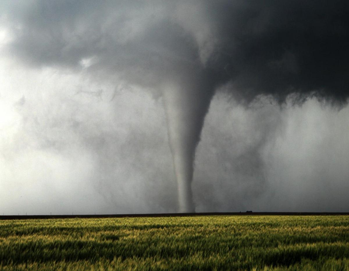
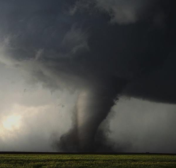
Tornado outside Wray, eastern Colorado chased by Weather Holidays Tour a few years ago:

Even Michael Fish has been out with Weather Holidays a few times
Having myself been out 6 times to the Great Plains to storm chase since my first time in 2007, three of those years driving for Weather Holidays, I can say I never lose the enthusiasm to go out there again, even though I have ticked-off everything there is to see from these supercell storms. The one thing that still draws me is videoing tornadoes ultimately, but just experiencing the awesome power of supercell storms and all they unleash, as in the UK we are unlikely to experience such power from Mother Nature.
Loading recent activity...