From the 15th -17th March 2021, the WMO (World Meteorological Organisation) Hurricane Committee has been meeting to reflect on the record-breaking 2020 Atlantic season (14 hurricanes, 30 named storms) and look forward to 2021 and future seasons. This annual event is when hurricane names can be retired and replacements decided upon and discuss the timing of the season and naming conventions. Traditionally, the Atlantic hurricane season runs from 1st June until 30th November. This will not change this year but some other alterations have already been discussed.
Just announced is the retirement of Dorian from 2019, the Cat 5 hurricane which sat over the Bahamas. Laura, a Cat 4 which hit Louisiana in August 2020 and the two November hurricanes Eta and Iota.
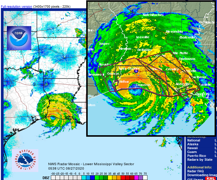
Hurricane Laura 2020
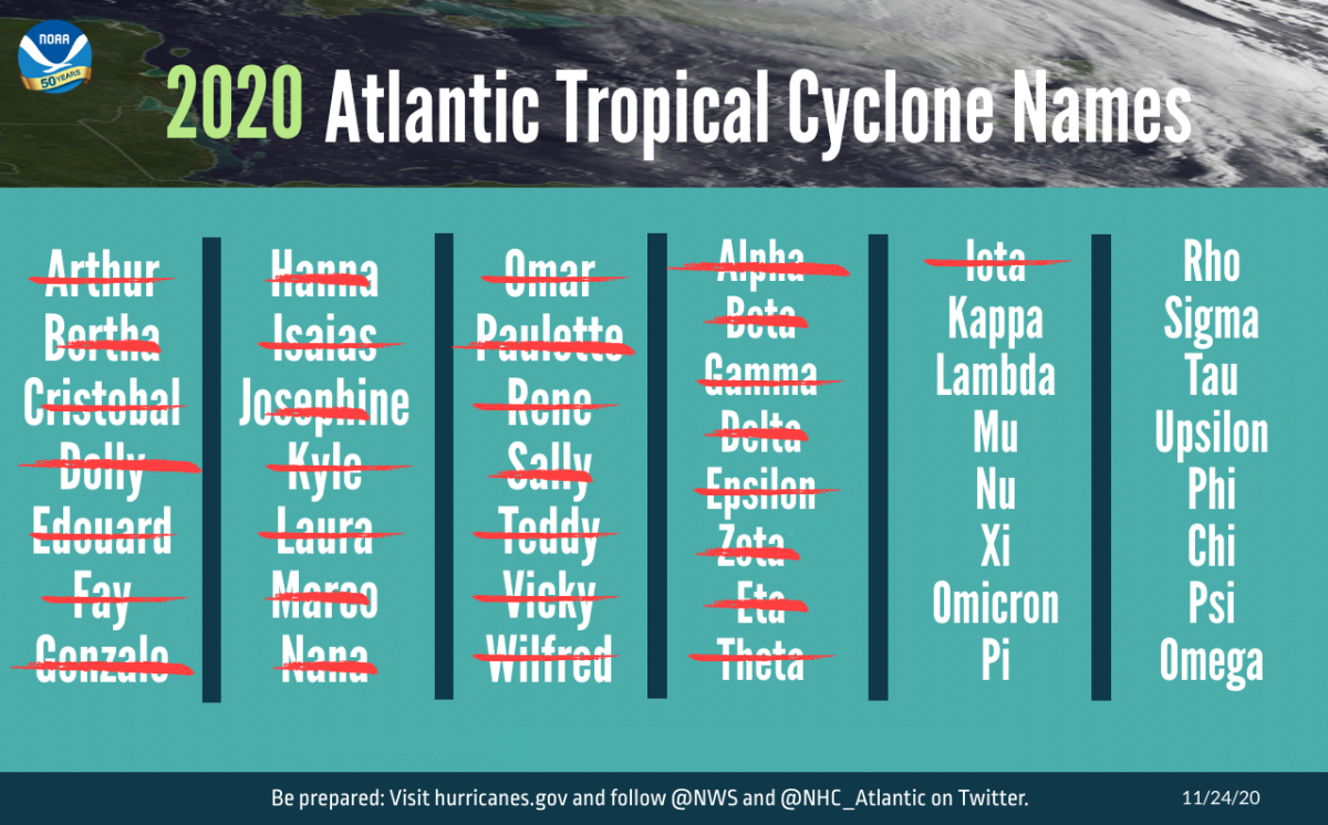
Is something new needed? Yes, it seems. The Greek alphabet will never be used again as it is "distracting and confusing". There will be a supplemental list of names A-Z to be used when the standard list runs out in one season. This remains different to the central Pacific naming list, which is circular, it just keeps on going. No running out of names or switching alphabets. The Regional Specialized Meteorological Centre (RSMC) is in Honolulu and for the Atlantic and eastern Pacific updates, they come from RSMC Miami, Florida.
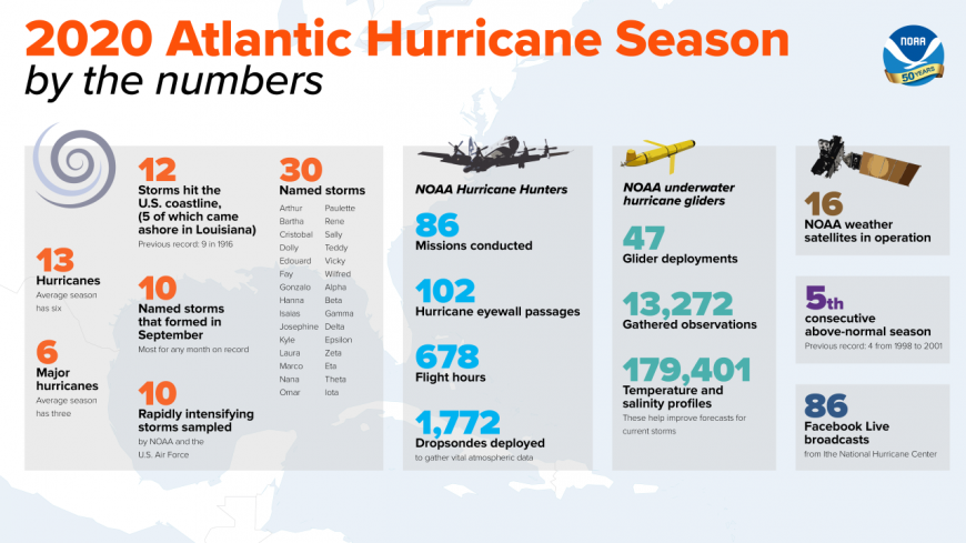
* Updated to 14 hurricanes in 2020 season with a post-season upgrade to Gamma in April 2021
There are five regional tropical cyclone bodies around the world, overseeing operational meteorology, hydrology and flood forecasting along with disaster risk reduction. The aim to save human life and keep damage to a minimum in the face of hurricanes, typhoons and cyclones. And of course, currently made more difficult because of the COVID pandemic. The Hurricane Committee serves North America, Central America and the Caribbean and will look at the operational plan for this upcoming season, its forecasts and warnings, impact assessments and the naming conventions. It will also have to look at the 2019 names as the committee meeting last year was curtailed as the COVID crisis took hold.
One that was already agreed was that the National Hurricane Centre (NHC) Tropical Weather Outlooks will begin earlier, in mid-May 2021. A future shift in the official hurricane season start could see that potentially line up to May 15th.
It is very unusual for the 21 letter names to all be used up in a season and the Greek alphabet even be required. Before 2020, it had only occurred in 2005, the year of devastating Hurricane Katrina and the most intense Atlantic hurricane recorded, Wilma. Some letters of the alphabet, such as Q and X, are not used as there aren’t deemed enough instantly recognisable names for the 6-year cycle with spares. The list alternates male/female and includes English, French and Spanish names.
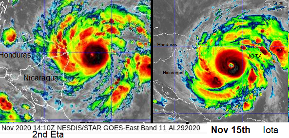
Hurricanes Eta and Iota, two weeks apart
If a hurricane is catastrophic in a certain area the name can be retired to hold that event in history and avoid subsequent confusion and a replacement is announced. The Greek alphabet wouldn’t work like that so there was chat after 2005 to add say “Iota 2020” onto the withdrawn list but keep using Iota when needed. Costa Rica has highlighted Iota and Eta and hurricane names can only be removed if a country asks. The international committee has voted, and removed the whole Greek alphabet. There were numerous issues with the Greek alphabet idea and it distracted from the main safety messages. Also, clarity in pronunciation and translation was an issue and these storms just kept on coming in 2020. The replacement names for Dorian and Laura are Dexter and Leah.
2020 was an extraordinary season, we shouldn’t expect that many named storms each year. However, 2020 was the sixth season in a row with above average activity. There were hundreds of casualties and billions of dollars of damage. Our global climate is changing, warming. Climate scientist’s research at the GFDL shows it is
“likely that greenhouse warming will cause hurricanes in the coming century to be more intense globally and have higher rainfall rates than present-day hurricanes.”
It doesn’t suggest we will keep reaching the Greek alphabet but there could be more retirements due to more powerful hurricanes and depending on where these cyclones hit. Nicaragua in 2020 was hit by two major hurricanes within weeks in November. The flooding for central America was devastating.
The 2020 season started early with a record nine named storms from May until July. It ended in November with the two major hurricanes, also unusual for a Cat3+ (never mind two) to develop so late on. In the end, there were 30 named storms, with 6 of the 14 hurricanes being major ones. The Louisiana coast seemed to attract storms; the tracks often looked like repeats curving in from the Caribbean. September 2020 was the most active month on record for the Atlantic and the last letter was used by September 18th for Tropical Storm Wilfred.
One thing to note, with better monitoring and policy changes, is that the early season systems include sub-tropical affairs which can still attract a name due to their wind strength (39mph+ sustained winds) but don’t last long.
Hurricane Gliders
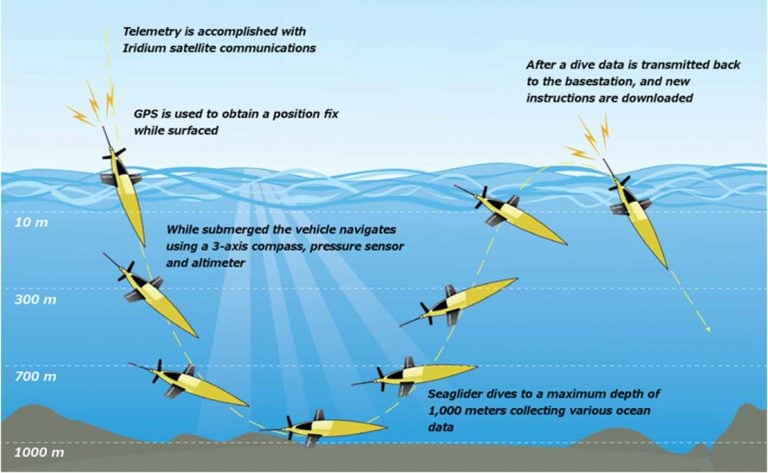
The US Air Force and NOAA Hurricane Hunter planes are well-known observers, flying towards and through hurricanes once they have formed. Less known are the underwater gliders which follow pre-set transects, dipping and rising measuring seawater temperatures and salinity. They gather observations that can be used to better represent the ocean conditions in the NOAA operational hurricane models. The ocean data can then improve the NHC forecasts for current storms. They don’t chase the storms, but the chosen routes are likely to coincide with some of the season’s storms. Hurricane track forecasts have improved in the last 20 years, but hurricane intensity forecasting has not kept pace. The birth, track and intensity of Atlantic hurricanes are linked to atmospheric and ocean conditions so both need investigating,
These improvements and developments, sharing and discussions of warning procedures and how areas, in particular the Caribbean, could suffer from these wetter, longer duration, more intense hurricanes is also part of the annual meeting. Gathering research and data to prepare for the next season.
NOAA issues its seasonal hurricane outlook for 2021 in May.
Atlantic hurricanes - your complete guide
Tropical Cyclones: Hurricanes, Typhoons and Super Cyclonic Storms
Loading recent activity...