"Iota is expected to remain a catastrophic category 5 hurricane when it approaches the coast of Nicaragua tonight. Forecast to bring catastrophic winds, life-threatening storm surge and torrential rainfall to Central America." National Hurricane Centre.
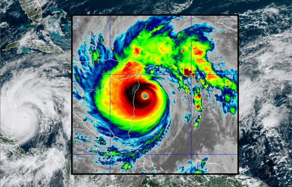
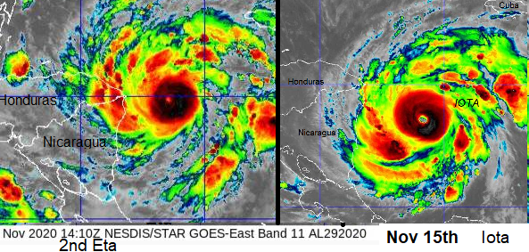
The grim image above shows Iota, now a Category 5 major hurricane heading for Central America on Monday 16th. Sustained winds of 160 mph and a central pressure of 917mb. This is the latest occurring category 5 hurricane in the Atlantic basin on record. There have never been two major hurricanes in the North Atlantic in November. Iota has never been used before as a name from the Greek alphabet list, 2020 has been an extremely active season and this is the strongest storm so far. Just under two weeks before, major hurricane Eta made landfall on the Nicaraguan coast on Tuesday, November 3rd, having peaked at a category 4. Both rapidly deepening in the day before landfall and Iota is not done yet.
“the pressure fell an amazing 10 mb from 945 mb down to 935 mb in a little over an hour” NHC discussion 12
Iota has just reached the highest category with sustained winds over 157mph in an environment of low wind shear, warm waters around 29C and plenty of moisture in the mid-level environment. This is a catastrophic cyclone and it seems unbelievable that is it heading towards the same region so soon after Eta, which brought torrential rain, devastating flooding and lethal landslides to other Central American countries as well as Nicaragua and nearby Honduras. Once more people are being evacuated to shelters, this time for an even stronger hurricane.
"Iota is a very impressive hurricane, especially for this late in the year, with a distinct, warm eye on satellite images and a rather electrified eyewall." NHC Discussion 13
Impacts
Storm Surge – Life-threatening storm surge. Water levels 15-20 feet above usual tide levels where the winds push onshore. Coast of Nicaragua and eastern Honduras. Large and destructive waves, large swell and rip currents
Winds- Catastrophic wind damage. Nicaraguan coast up to northeast Honduras as landfall occurs later on Monday, local time. Tropical storm conditions from late afternoon.
Rainfall – Leading to significant, life-threatening flash flooding and river flooding with mudslides in mountainous regions
Honduras, northern Nicaragua, SE Guatemala and southern Belize: 10 to 20 inches (250 to 500 mm). Isolated maximum totals of 30 inches (750 mm) will be possible, especially from NE Nicaragua into northern Honduras.
100-300mm of rain possible for El Salvador, Panama, S. Nicaragua and Costa Rica

Although Iota will rapidly weaken once inland the ongoing rainfall on top of the conditions left by Eta are expected to lead to “significant to potentially catastrophic impacts.”
More discussion on Hurricane Iota in the Netweather community forum
Loading recent activity...