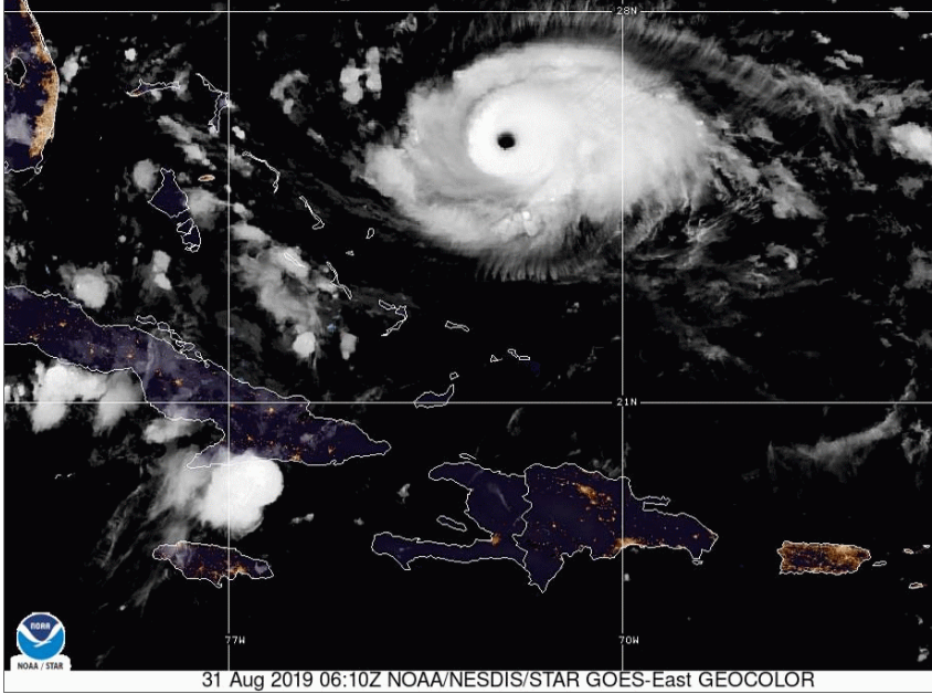
Hurricane Dorian in the Atlantic August 2019
A look at low pressures or cyclones in their many forms and stages of development. An anticyclone is a high pressure. A cyclone is a low pressure, a closed circulation in the atmosphere. Alongside this explanation are sections of the National Hurricane Centre (NHC) discussion text from Ernesto August 2018
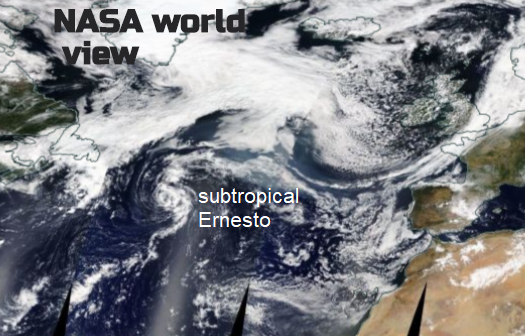
It is interesting to note that so far this hurricane season, four of the five systems have been a subtropical cyclone at some point in their lifetimes 15th Aug NHC
You can get a subtropical storm, a post-tropical hurricane, an extratropical low or a tropical depression. And various other combinations. Naming draws together two parts; a physical strength of the winds and its characteristics, alongside structure of the cyclone's core and how it gets its energy.
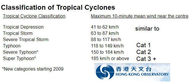
In the northern hemisphere, low pressures rotate anticlockwise, in the southern hemisphere, low pressures rotate clockwise. It throws you when drawing fronts on a chart. All cyclones are low pressures but depending on wind strengths and characteristics the strongest cyclones get descriptions. (They can also get names but that is not for this blog). In the Atlantic and eastern/central Pacific, we use Depression, Storm, Hurricane and major hurricane. In the western Pacific; Typhoon and Super-Typhoon are used. For other parts of the world, such as Australia and the Indian Ocean just plain old Cyclone is used. Below Irma 2017
Wind Strength
Usually for the Atlantic, in the warm waters of the Caribbean a Tropical Depression TD forms. A TD has winds up to 38mph. Next, it may strengthen to a Tropical Storm, TS with winds between 39 and 73mph. A hurricane has winds over 73mph. Within the hurricane banding, there are 5 categories 1-5 with 3,4 and 5 being classed as Major Hurricanes. Saffir Simpson Hurricane Wind Scale
When naming significant low pressures one part of the name is governed by specific wind strength categories relating to peak 1 minute winds (US) or by the maximum sustained wind speeds near the centre averaged over a period of 10 minutes (WMO). That bit is straightforward enough.
Cyclone characteristics and structure
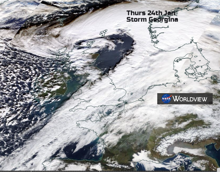
Like E.T. an Extra-Terrestrial is non- worldly, not of this earth. An extra-tropical low is non-tropical, it doesn't have tropical characteristics. It usually forms in the mid-latitudes. It doesn't have extra powers, the name is quite ill-fitting. In the UK, our usual Atlantic lows are extratropical, their energy source being from a temperature contrast, warm air against cold. Baroclinicity. These systems have fronts and appear as a comma shaped cloud on satellite imagery. Below extratropical Low named Georgina in the UK and Eire Name our Storms project.
Post-tropical cyclones were once tropical. So post - after . When a tropical cyclone loses certain characteristics such as organised deep convection, it becomes post-tropical. This is the point when a hurricane in the Atlantic near to western Europe gets media attention and questions asked of when is a hurricane not a hurricane, when it goes post-tropical. At this point, the cyclone can become a remnant low, if its winds diminish to below 38mph. These still can bring heavy and persistent rains.
Ernesto: Slow strengthening is possible during the next 24 hours or so while the system remains over warm SSTs and in fairly low wind shear conditions. After that time, sharply colder waters, drier air, and a significant increase in wind shear should cause extratropical transition in about 48 hours, or sooner, and a gradual weakening. The models show the post-tropical system merging with a frontal zone in 3 to 4 days. NHC
You may hear media forecasters speaking about "the remnants of Hurricane Betty" Or it becomes an extratropical low where the baroclinicity in the northern Atlantic keeps the system going. These systems can still have hurricane or storm force winds but are no longer considered to be a proper hurricane. Sometimes the post-tropical cyclone is swallowed up by existing extratropical lows and everything gets jumbled up.
A Subtropical cyclone hasn't reached full tropical status. It is underdeveloped -sub. It may or it may not become truly tropical, but it is showing some signs. A low pressure system which develops with a non-tropical circulation but has some elements of tropical cyclone cloud structure. Depending on where they form there may be a moderate horizontal temperature gradient (baroclinicity) providing energy but there are also convective clouds (like tropical cyclones) and there aren't any fronts. They are less symmetrical, don’t have a Central Dense Overcast, CDO the dense cirrus shield and generally have an upper cold core . Often these storms have a larger radius of maximum winds, over 60 nm from the centre. True tropical system's winds are often more compact.
Ernesto :The low pressure system that the National Hurricane Center has been monitoring over the central Atlantic Ocean has developed sufficently organized deep convection and a well-defined centre. Since the system has a large radius of maximum wind and is co-located with an upper-level low, it is being classified as a subtropical depression. NHC
Although inner-core convection has increased since the previous advisory, outer banding features have become more fragmented and the overall cloud pattern has become elongated north-to-south. There are also no signs of any upper-level anticyclonic outflow, an indication that Ernesto is still a subtropical cyclone.
Convection developed closer to the centre of Ernesto early this morning, suggesting that the system was attempting to make the transition to a tropical cyclone, but that area of convection has weakened within the past couple of hours. Patches of deep convection continue over the outer portion of the circulation, and a very recent ASCAT overpass continues to show a rather large radius of maximum winds, indicating that Ernesto remains a subtropical cyclone.NHC
So what are these Tropical characteristics?
NHC Tropical Cyclone "A warm-core non-frontal synoptic-scale cyclone, originating over tropical or subtropical waters, with organised deep convection and a closed surface wind circulation about a well-defined centre. Once formed, a tropical cyclone is maintained by the extraction of heat energy from the ocean at high temperature and heat export at the low temperatures of the upper troposphere"
It needs a warm core and a symmetrical structure. Deep convection and a wall cloud develops resulting in an organised band of cumuliform clouds immediately surrounding the centre of a tropical cyclone. The distinctive eye of a hurricane often gives a chill to viewers of satellite sequences.
Visible and infrared satellite imagery shows that convective banding has increased closer to the centre of Ernesto today. The system has also lost much of its outer cloud bands and is no longer co-located with an upper-level low. On this basis, Ernesto is now being classified as a tropical storm. NHC

Gradually as the cyclone heads northwards, it moves over cooler waters and things begin to change. It is said that the UK doesn’t get proper hurricanes, but with climate change and our warming planet will the day come when the change from a true tropical cyclone to a post tropical one hasn’t taken place in time.
Ernesto has about 24 hours over marginally warm SSTs and in a low-shear environment in which to strengthen. After that time, the cyclone will be moving over much colder water which should cause it to become post-tropical within 48 hours. The post-tropical cyclone is forecast to merge with a frontal zone associated with a larger extratropical cyclone over the North Atlantic in 3 to 4 days. NHC
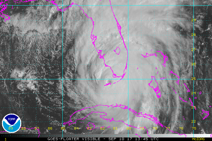
The tropical cyclone can just fade away to nothing, but near to the UK they usuallly get caught up in other systems or undergo extra-tropical transition. The process of extra-tropical transition ET involves a gradual change of structure from a warm core and a symmetrical system, to a cold core asymmetrical system.. For those who watched Hurricane Ophelia heading towards the UK in autumn 2017, this transformation process can be elongate. Even after it takes place there can still be intense winds and rainfall.
Ernesto is somewhat surprisingly maintaining convection and well-defined banding features over the northern and eastern portions of its circulation despite being over SSTs of 20-21C. The cloud tops have warmed within the past couple of hours perhaps an indication that Ernesto is finally beginning to lose its tropical characteristics.NHC
With some understanding of these various prefixes to the words tropical cyclone, hopefully, it will aid the weather forecast message when low pressures and storms approach. Unlike reading the hysterical tabloid outbursts every time something vaguely tropical heads our way.
Ernesto's cloud pattern has deteriorated since this morning with deep convection decreasing in coverage and becoming a little more separated from the low-level center. However, there is still enough organized convection to maintain the system as a tropical cyclone a little longer.
Organized deep convection associated with Ernesto has dissipated after the issuance of the last advisory. If it does not return, which seems unlikely with the system moving over SSTs of 16C or less, Ernesto should become a post-tropical cyclone by early Saturday.
Geostationary and microwave imagery along with ASCAT data indicate that the mid-level circulation has begun to separate from the low-level center, the initial intensity remains 40 kt. Ernesto is forecast to weaken only a little during the next 24 hours while it approaches Ireland and merges with a frontal zone Saturday night
Ernesto lost all its associated deep convection and the circulation is becoming elongated. On this basis, it is estimated that Ernesto has become a post-tropical cyclone. The system could still produce 35-kt winds in the southeastern quadrant, but it should continue to slowly weaken during the next 24 hours while it approaches Ireland and merges with a frontal zone later today. The post-tropical cyclone or its remnants are expected to spread gusty winds and locally heavy rain over portions of Ireland and the United Kingdom tonight and early Sunday. NHC
Loading recent activity...