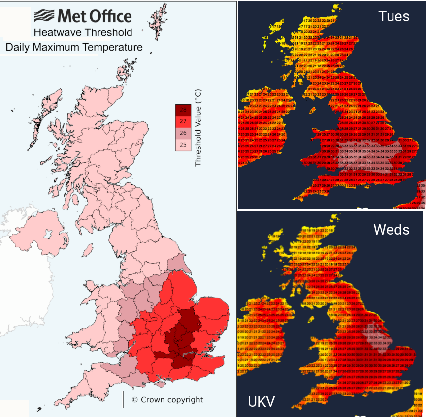
This week will be much warmer for many parts of the UK with hot weather and sunshine leading to heatwave conditions for some. This will be the fourth official heat wave in England, of the 2025 summer season, when three consecutive days reaching local threshold temperatures are recorded. A few places in England have already recorded Day1 with threshold values varying across the UK, from 25C up to 28C in the southeast.
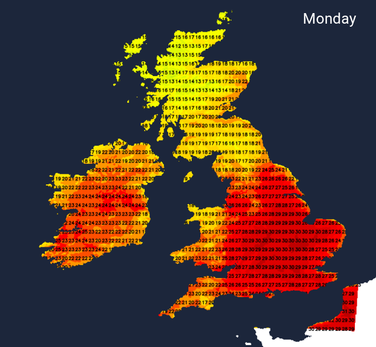
Temperatures on Monday will widely be in the 20s Celsius with the top values being around 29 to 31C. Northern Britain and northern Wales will see more cloud with temperatures in the high teens and low 20sC.
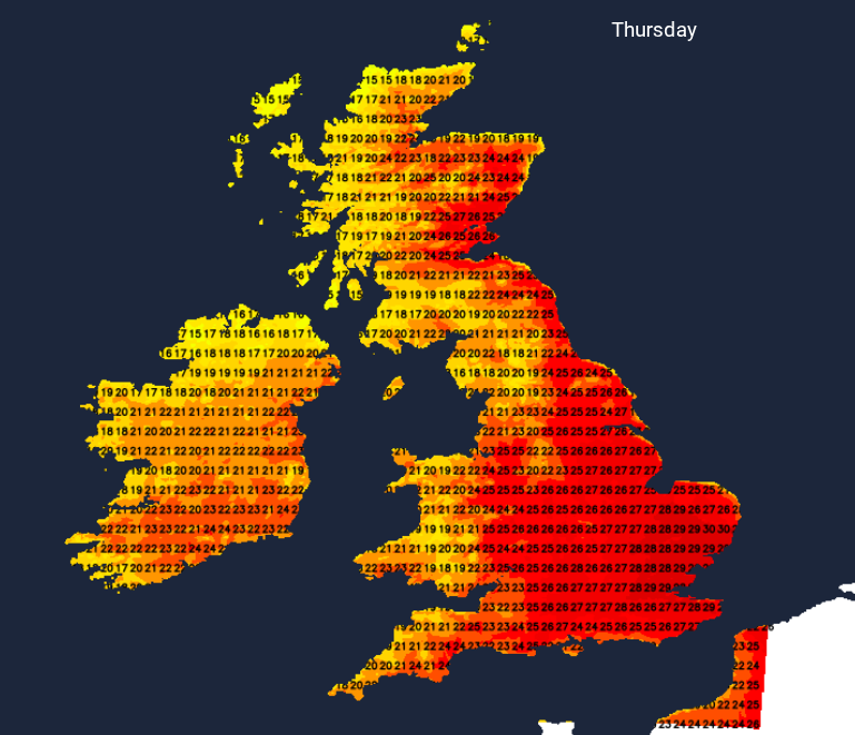
With mostly light winds, more sunshine and the feed of heat from the south, Tuesday will feel hotter for many. Central inland southern Britain will see the highest temperatures with 33 or 34C looking likely, even 35C possible on Tuesday. By Wednesday, there could be a southwesterly flow, limiting the heat for western Wales and western England, also clipping Sussex. Tuesday might stand out as the hottest day of this week but temperatures will stay up around 27 to 31C in England. Some parts of eastern Scotland could reach the heatwave criteria by Thursday, passing 25C each day. An inland central swathe of England should reach heatwave criteria by Wednesday, even a few inland places down through the West Country.
You might be delighted about the prospect of heat and sunshine although that may depend on what you have to do over the coming days. It’s back to school in Scotland this week and next. For others, ongoing hot weather and uncomfortably warm nights are a strain, even a worry. Age Concern has some good advice online and people with pre-existing conditions should take extra care.
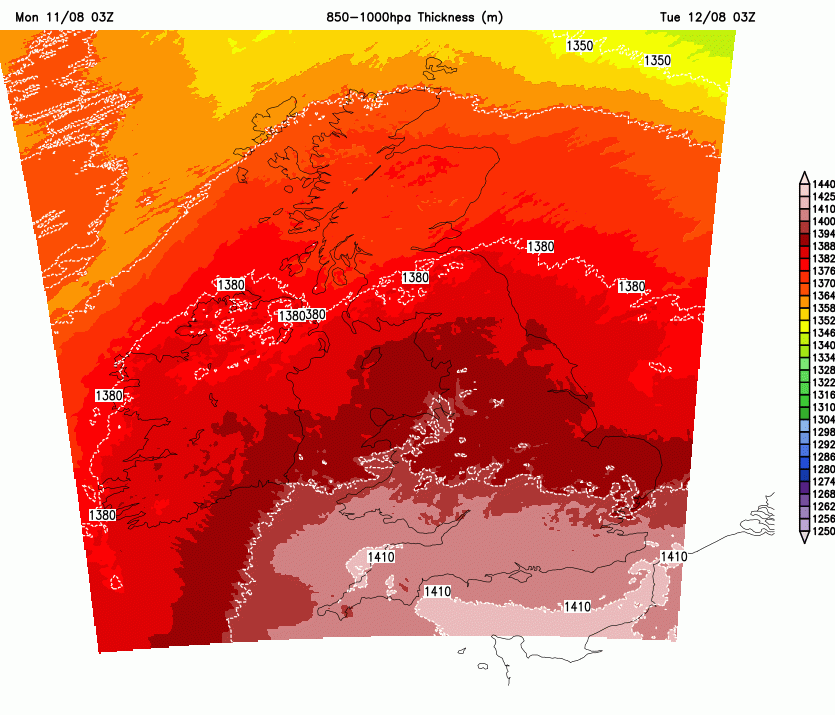
There is high pressure nearby trying to settle the weather down. There is a southerly flow drawing up hot air from southern Europe, where there have been ongoing heat warnings and astonishing temperatures in the high 30s and low 40s Celsius. The southerly flow around the high will steer this heat to the UK, reaching northwards to Scotland on Tuesday.
It will stay warm all week, the focus of the heat will move about over eastern Britain on Thursday, back to southern Britain for Friday. With this backdrop of hot air from Europe, when the sunshine does appear, then the temperatures will shoot up.
On Sunday, the highest temperature in the UK was 27.8C at Astwood Bank is near the Warwickshire/Worcestershire border and at Northolt, Gt London. Saturday night had been cool and in Northern Ireland, Katesbridge fell to 3.8C. The coming nights will be warmer, with temperatures in the heatwave areas remaining in the mid to high teens. Some could record Tropical Nights when the minimum temperatures don’t fall below 20C
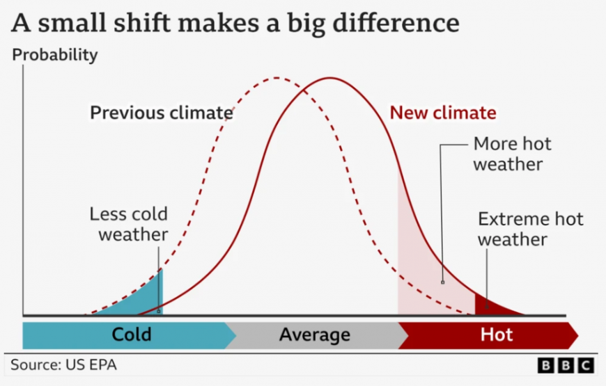
Our climate is warming, and even a small shift in temperatures can significantly increase the frequency and intensity of extreme weather events.
“When comparing the most recent decade 2015-2024 to 1961-1990, the hottest summer days and coldest winter nights have warmed around twice as much as average summer days and winter nights have in some parts of the UK.” Royal Met. Soc. State of the Climate
The conditions in southwest France are incredible, with temperature records falling and the possibility of more being broken this week.
Rainfall and water
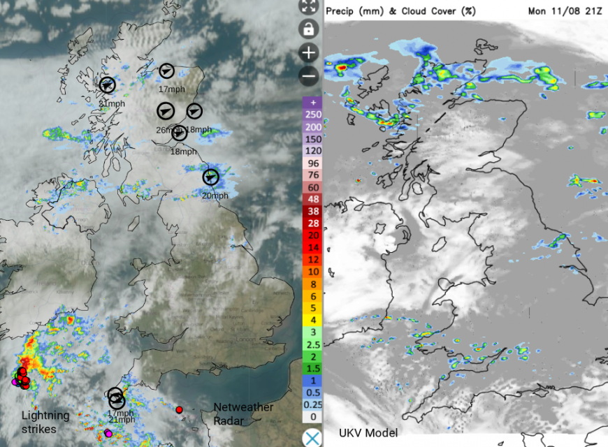
We are in for a very warm or hot week with many areas staying dry, which will add to the water supply strain. There could be a few well-scattered showers on Tuesday. A fading frontal band will bring showery rain and more cloud over southern Scotland on Tuesday night with the chance of showery outbreaks still through the Central Belt and eastern Scotland early on Wednesday, even thundery ones. It will begin to feel more humid and close midweek. This showery risk moves northwards through mainland Scotland but again most places will remain dry. Thursday includes the risk of scattered heavy showers and thunderstorms but many places will stay dry and feel warm.
Eastern Britain will see the highest temperatures, with a slight easing further west. The light flow will veer to the west, but it will be a rather calm day and this lack of wind means that any heavy showers will be slow-moving. Friday looks hot again in the south but with more cloud and possibly damp weather in the north.
Loading recent activity...