What was the worst ever Atlantic hurricane, the strongest, the deadliest, the costliest and the earliest or latest? Do we get hurricanes in the UK and how do the categories and naming work? We’ll take a look at some of the extreme hurricanes in history whilst remembering some of those that have come close to the UK.
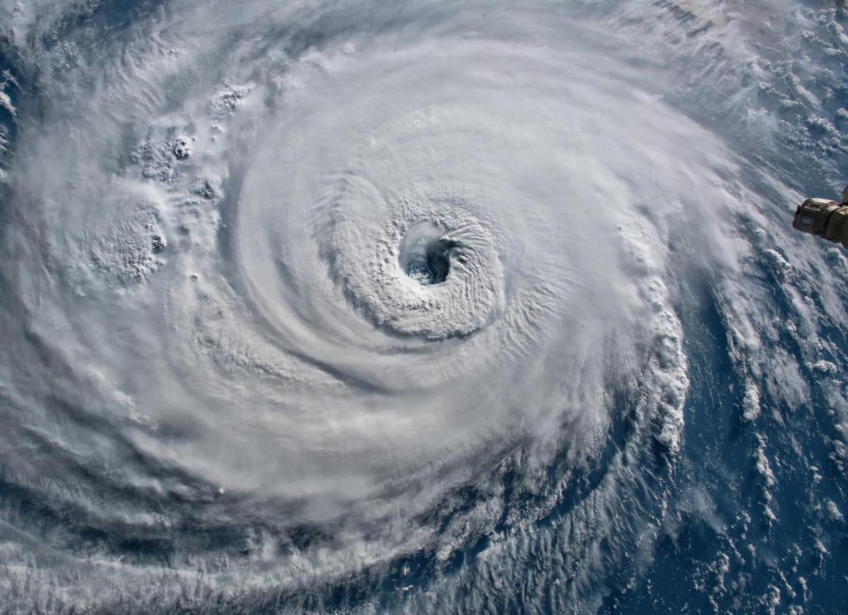
Hurricane “A tropical cyclone is a general term used to describe a rotating, organized system of clouds and thunderstorms that originates over tropical or subtropical waters and has closed, low-level circulation.” They have a warm core, a very distinctive look on satellite imagery and become hurricanes once their sustained winds reach a set speed. " A warm-core tropical cyclone in which maximum average surface wind (one-minute mean) is 118 km/h (74 mph) (64 knots) or greater. "WMO
The Atlantic hurricane season traditionally runs from the 1st June until 30th November. Within that, September is usually the most active month yet the number of named storms, hurricanes and major hurricanes varies greatly year on year. As will the paths; west through the Caribbean Sea to Mexico, up to Florida, the eastern seaboard or sometimes in the mid-Atlantic and then north closer to western Europe.
Timings can vary with disregard to “the season” and the strength and damage stretch from a 'fish spinner' well out at sea to a Category 5 monster making landfall with destructive winds, huge rainfall with landslides and storm surge flooding.
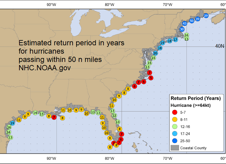
Cost comparisons are difficult due to inflation but adjusted figures are issued. Major hurricane events back in history don’t always have reliable figures and they also lacked the widespread warning systems now in place from the National Hurricane Centre (NHC).
Hurricanes are found in the Atlantic and the eastern & central Pacific, the Western Hemisphere. They are cyclones, low pressures and the same as Typhoons just with a different name. Tropical cyclones are called Typhoons in the western Pacific and just Cyclones around Australia, the south Pacific and in the Indian Ocean.
A tornado is different, hurricane-force winds are different. The UK and Ireland do not get hurricanes but can be affected by ex-hurricanes, the remnants or post-tropical systems which still can bring very wet and/or very windy weather. On the Beaufort wind scale which has Force 8 gale for sustained winds of 39-46mph, Force 12 relates to hurricane-force winds of 73mph plus.
A hurricane is a specific type of low pressure, it is formed in a certain way, has a warm core, a barotropic symmetrical structure and winds of a certain speed. The wind speed governs progress from Tropical Depression to Tropical Storm up to the category of Hurricane. There are five categories of hurricane “strength”, with 5 being the strongest and most devastating and 3,4,5 considered as Major Hurricanes due to their potential for significant loss of life as well as the damage.
All hurricanes should be considered potentially dangerous and phrases such as “downgraded from Cat 5 to a Cat 3” can be unhelpful. Also, a scale that relies on wind strength may not give enough emphasis to lethal storm surge danger or heavy rain and flooding.
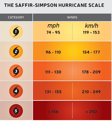
A scale estimating potential property damage is used for hurricanes called the Saffir-Simpson hurricane wind scale.
Names are given at Tropical Storm stage, with only a number for Tropical Depressions. Typhoons are named at equivalent hurricane stage. Comparing to Typhoons, Super Typhoon is used once sustained winds exceed 150mph, so a high Cat 4 and Cat 5.
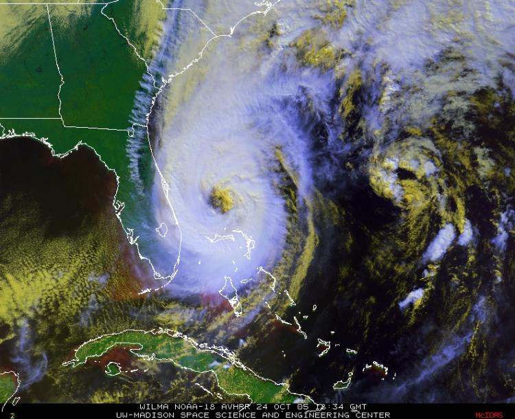
Wilma is the most intense hurricane with the lowest minimum pressure ever observed in the Atlantic basin. In the NW Caribbean Sea, a central pressure of 882mB was recorded. It caused damage and deaths in the Yucatan peninsula, Haiti and southern Florida with major flooding in western Cuba.
“The 882 mb pressure reported in Wilma is the lowest central pressure on record in an Atlantic hurricane, breaking the old record of 888 mb set by Hurricane Gilbert in September 1988. The central pressure fell 88 mb in 12 hours, which shatters the record of 48 mb in 12 hours held by Hurricane Allen in August 1980.” NHC
Hurricane Allen moved through the Caribbean Sea into the Gulf of Mexico in the summer peaking three times as a Category five storm, It stayed at Cat 4 or 5 from the 4th until the 10th of August, mostly out at sea before hitting Texas bringing torrential rain, a storm surge and damaging winds. It had originated near the Cape Verde Islands in the eastern Atlantic moved north of Barbados but causing great damage on St. Lucia. It affected Jamaica, and Cuba and particularly Haiti.
Also Hurricane Allen 1980 Its strongest winds reached 190mph.
This is considered to be the most deadly Atlantic storm and responsible for at least 8,000 deaths, possibly up to 12,000. The storm surge of 8 to 15 feet inundated the whole of Galveston Island. This was responsible for the majority of the deaths.
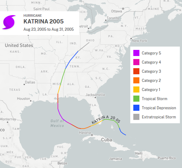
The costliest storm on record for the US. Massive inland flooding resulted in many deaths and large-scale damage. At least $108 billion dollars of damage, mostly concentrated around New Orleans and the Mississippi coastline. After crossing southern Florida a few days earlier as a Cat 1, it loomed in the Gulf of Mexico as a sinister Cat 5 before making landfall twice as a Cat 3. Around 1,200 people died, mostly in Louisiana with widespread wind and water damage. It remains the third deadliest hurricane to strike the United States.
One of the greatest concerns of the National Weather Service (NWS) amongst their hurricane preparedness team is that the public and even those in power might think that the advances in technology and improved hurricane forecasts can protect them from a huge loss of life. This is not the case.
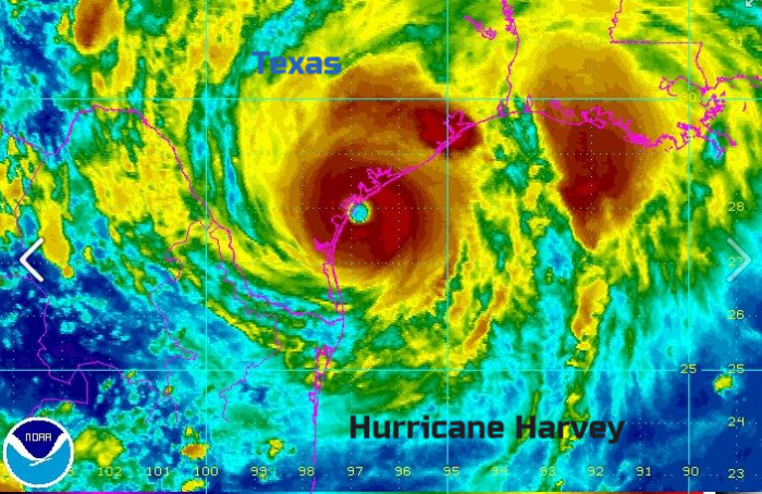
Hurricane Harvey (2017) ranked second costliest for US, Hurricane Maria (2017) ranked third, Hurricane Sandy (2012) ranked fourth and Hurricane Irma (2017) ranked fifth with adjustments for inflation. Hurricane Maria is the costliest hurricane on record to strike Puerto Rico and the U.S Virgin Islands.
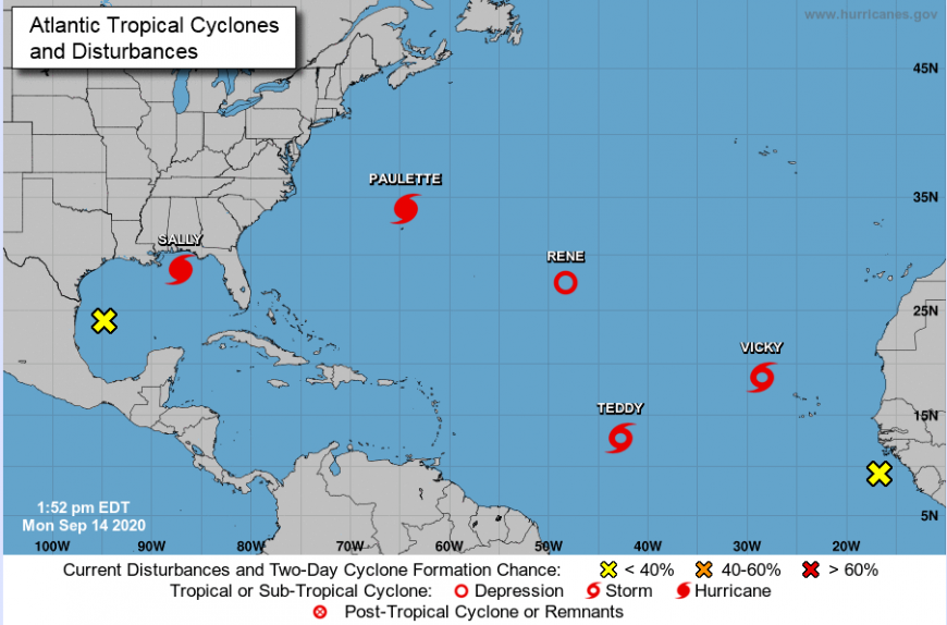
Four hurricanes occurred in the Atlantic basin at the same time in Aug 1893 and Sept 1998.
Hurricane Dorian was an incredible cyclone. It peaked with sustained winds of 185 mph. This Cat 5 storm can be viewed as one of the most powerful hurricanes ever seen in the Atlantic Ocean. The image of that eye over the Bahamas will continue to send chills through people for decades to come. The name has now been retired.
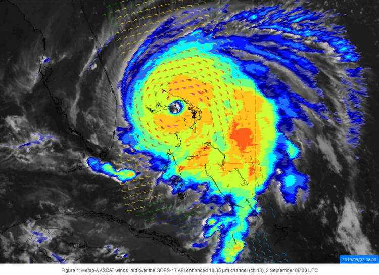
Joint strongest Atlantic winds at landfall – 185mph sustained winds on Great Abaco, Bahamas tied with the Florida Keys Labour Day hurricane of 1935 which also hit as a Cat. 5. It was the strongest storm to hit the Bahamas and for the areas north of the Caribbean and east of Florida.
Rapid Intensification Dorian gained strength at record speed. In just nine hours on Sunday, its peak winds increased from about 150 mph to 185 mph — a rate of intensification never observed for a storm this strong. Storms had rapidly intensified but not from this initial high intensity of 150mph.
Tropical cyclones are very rare here. In March 2019 Iba formed as a rare tropical storm off the southeast coast of Brazil. It was one of only four cyclones known to have formed in the southern Atlantic Ocean and there has been only one known hurricane - Catarina. A Cat 1 in March 2004. The SSTs are too low and there is plenty of wind shear. Also, tropical waves don’t roll of western Africa south of the equator, so the initial disturbances are missing.
To consider timings such as the earliest and latest in the year we should first look at naming conventions.
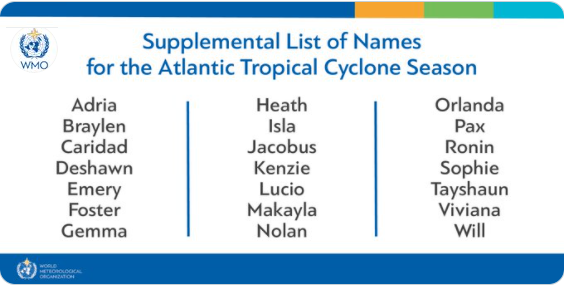
The list of names is predefined and can be found here. The World Meteorological Organisation (WMO) oversees the naming and there are strict rules. Six lists are used and then reused. Names are only removed if a storm is so devasting that reusing it would be deemed inappropriate. The usual annual WMO meeting in 2020 was affected by the global Coronavirus outbreak and the usual week-long conference was moved online. As the meeting was shortened, several key decisions were postponed.
There are different lists for different parts of the world and a list for Atlantic hurricanes, for eastern Pacific ones and central Pacific storms. (The central Pacific list is circular, it does not restart each year.)
Not every letter is used, due to the availability of names starting with that letter. It moves from female to male, then changes to start male to female the following year. The practice of just using female names ended in 1978. If all 21 letters are used, up until 2020 the naming moved onto the Greek alphabet. This has only happened twice.
However, at the WMO session in 2021 the annual review committee decided that the Greek alphabet was confusing, it did not allow for retirements and after the record-breaking 2020 season, a replacement list would be used instead.
If a hurricane or tropical storm moves from the Atlantic over to the Pacific, say by crossing Central America westwards, they used to be renamed to fit with the other list. However, that no longer occurs. Hurricane Otto in November 2016 moved oceans but kept its original name as an Atlantic-Pacific crossover hurricane.
Latest Hurricane The active 2005 season saw letters Alpha, Beta, Gamma, Delta, Epsilon and Zeta used. Hurricane Epsilon was still active in early December, the latest hurricane on record in an Atlantic season. Tropical Storm Zeta existed from late December into early Jan 2006 and yet the season had only started in early June, that was a lot of storms to fit in.
Hurricane Alice confuses the issue as it became a hurricane at the very end of 1954 but was named for the next season. So it was the latest ever hurricane in a calendar year and continued into 1955. So like TS Zeta it moved from one calendar year to the next. Zeta reached naming strength in December, Alice over the New Year.
In 2020, ten storms formed in September, the most in any single month on record. In November 2020, two major hurricanes (Eta and Iota, a Cat.5) formed, the first time this happened so late in the season.
2005 had the most hurricanes with 15 in the season (from 28 storms). 2020 had 14 hurricanes and 30 named storms and was deemed the most active season on record by NOAA. In 1971 and 2020 there were five tropical cyclones in the Atlantic basin and active simultaneously.
Hurricane Alice is the earliest hurricane in existence in a year and moved over the eastern Caribbean Sea. As mentioned it formed at the very end of December 1954 so should it have followed Hurricane Hazel in name in another very active season? The naming conventions were different then and there had already been a hurricane Alice in June 1954.
Back in January 2016, Hurricane Alex formed very early. This would be the earliest hurricane to form in a calendar year.
HURRICANE ALEX DISCUSSION 4 NWS NATIONAL HURRICANE CENTER MIAMI
1100 AM AST THU JAN 14 2016
“Remarkably, Alex has undergone the transformation into a hurricane. A distinct eye is present, embedded within a fairly symmetric mass of deep convection. Water vapor imagery shows that the upper-level trough is now west of the cyclone, with divergent flow over the centre - indicative of a tropical transition. It is very unusual to have a hurricane over waters that are near 20 deg C, but the upper-tropospheric temperatures are estimated to be around -60 deg C, which is significantly colder than the tropical mean. The resulting instability is likely the main factor contributing to the tropical transition and intensification of Alex. With these changes, the government of the Azores has issued warnings for most of the Azores islands.”
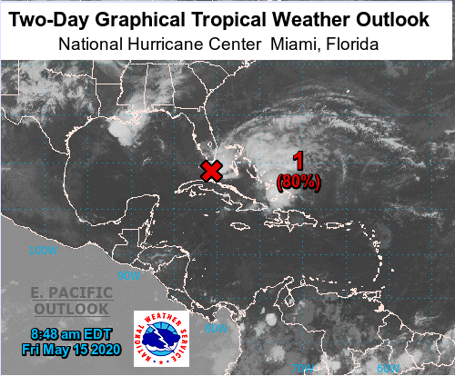 Two day tropical cyclone formation chance 15/05/2020
A pre-existing disturbance can be the starting point for a cyclone forming and the NHC issues % alerts about these, as areas to watch. Traditional teachings would mention Sea Surface Temperatures (SSTs) of +26C but cyclones can form with lower SSTs if there are very cold upper-level temperatures. This contrast allows deep convection through the atmosphere and as long as the wind shear (the change of wind direction with height) isn’t too much then a warm core can form in the circulation. These symmetrical warm cores are the defining part of a true tropical cyclone. Tropical low pressures are different from the extra-tropical (ET) lows. Condensation releases the heat energy, latent heat, stored in the water vapour. Our usual mid-latitude lows are still cyclones but are ET ”outside of the tropics” and form differently with air mass temperatures contrasts (baroclinic) and are cold-cored.
Understanding these differences helps when a tropical system begins to head towards NW Europe. As it moves north over the colder waters, it begins to change into a different type of low pressure. This transition can take time, it’s not like flicking a switch, but it can keep meteorologists on their toes as hurricanes like Ophelia kept on coming and coming, still with signs of a warm-core.
The ongoing question "Can we get hurricanes here in the UK?" Michael Fish’s forecast before the October Storm of 1987 was partly correct- “is there a hurricane on the way?” “don’t worry, there isn’t”. And there wasn't a warm-cored tropical cyclone on the way. He did then mention a low pressure with strong winds which was forecast to move over Spain and France. However, this low underwent explosive cyclogenesis and brought hurricane FORCE winds to the south of England and a gust of 120mph before the anemometer broke in Sussex. Not a hurricane but still a violent storm with sting jet winds.
There have been tropical storms and hurricanes which have got close to the UK, France and Spain. With climate change, our warming atmosphere and seas it seems anything is possible as records fall, and unusual meteorological occurrences take place.
In terms of weather, even post-tropical systems can bring damaging stormy weather with widespread gales, hurricane-force gusts, heavy rain and flooding often with a weird warm, humid feel to the air. These low pressures are often labelled linking to the tropical name. Ex-Lorenzo or ex-hurricane Lorenzo referring to their tropical origins. To truly get a hurricane here in the UK, the system would need to still be A. at hurricane strength with sustained winds over 73mph and B. still be barotropic, not have transitioned. The warm seas issue seems to be less important than the increasing wind shear at higher latitudes which disrupts the structure up through the atmosphere.
There are some events of interest:
Hurricane Debbie 1961 near Ireland - The hurricane’s cloud did reach Ireland, but landfall is not clear. It was a Cat 1 near Ireland and still had strong winds as it headed to western Scotland.
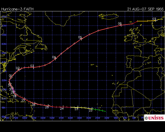
Hurricane Faith 1966 - Considered to be the furthest north a hurricane has reached before transitioning. Cat 1 near the Faeroe Islands by September after a huge path from Cape Vere Islands west to the Antilles and then north to near Norway, 12,700km
Tropical Storm Grace 2009 came very close to the UK, undergoing transition as it reached SW Britain. This caused quite a stir as it had a visible eye showing on the satellite imagery not far from the UK
Hurricane Fran 1973 got quite close to western Europe as a Cat 1 before transitioning.
Hurricane Vince 2005 hit southern Spain as a Tropical Depression, but still a tropical system at landfall in October 2005.
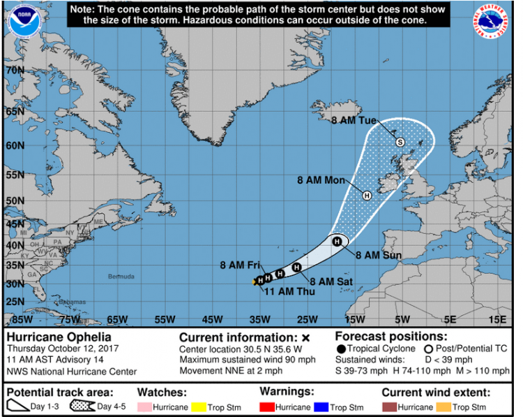
Hurricane Ophelia 2017 Ophelia was exciting to watch heading north. That was the one that brought the strange reddish-orange skies and tinge to the sun in October as it drew up dust-laden air from the south. Before every update, we waited to see if Ophelia has begun its transition and she just kept on coming. It had no significant horizontal temperature gradient, was still symmetrical and had a warm core. The transition at these latitudes can be quick, over just a few hours gaining baroclinic properties such as a warm sector and developing fronts as the symmetry disappears.
Hurricane Lorenzo 2019 - In September 2019, Hurricane Lorenzo made history. "The Cat 5 hurricane travelled further east and north in the Atlantic Ocean than any previous storm of the same strength". NHC. By early October is had weakened to a Cat 1 and was near the Azores. It then moved north transitioned and brought heavy rain to Ireland.
Hurricane Pablo 2019 - Not far behind Lorenzo was Hurricane Pablo which became the hurricane that had developed the furthest east. This was also quite unnerving to see, briefly. It didn't linger. Modern records date back to 1950.
The NHC discussion for Pablo talked about it reaching hurricane status - "The intensification has occurred while Pablo is over sea surface temperatures of 19-20C" others saying even cooler than that. Textbooks would talk about waters 26+C providing the warmth and energy for a hurricane to form. This was not the case. What was present was very cold upper-level air which supported convective instability, even with SSTs only in the high teens. The moist, unstable atmosphere also had low shear, so the structure up through the atmosphere wasn't disturbed, a warm-core formed and the winds strengthened.
”Despite its short lifetime, Pablo will be a talking point for years to come for its place in Atlantic hurricane history: It formed farther east than any other Atlantic hurricane on record, claimed second place on the list of farthest north-forming storms”
This keeps on happening, farthest north or east, unusual this unusual that, record-breaking high or low. What will be next? Is it that unthinkable that a hurricane will reach the UK?
Cyclones around the world: typhoons, hurricanes and super cyclonic storms with the Regional Centres and intensity scales
Historical hurricane tracks from NOAA
Hurricane and Cyclone thread in the Netweather forum.
Loading recent activity...