Evacuations from the Getty Fire continue in the LA area. A possibly unprecedented "extreme" red flag warning is out as strong, very dry winds are forecast for California.
"Extremely critical fire weather conditions continue across parts of California through Thursday, especially for southern California. Powerful and strong offshore Santa Ana winds will combine with very low relative humidity levels and overall dry conditions to create unfortunately favourable conditions for rapid fire growth and extreme fire behaviour of existing and new fires."
Conditions are so precarious with various weather and fuel ingredients poised there could a major fire event, which is why the Weather Services have highlighted this Red Flag warning as Extreme. To make sure people realise this next day or so could be very serious and different from previous red-flags.
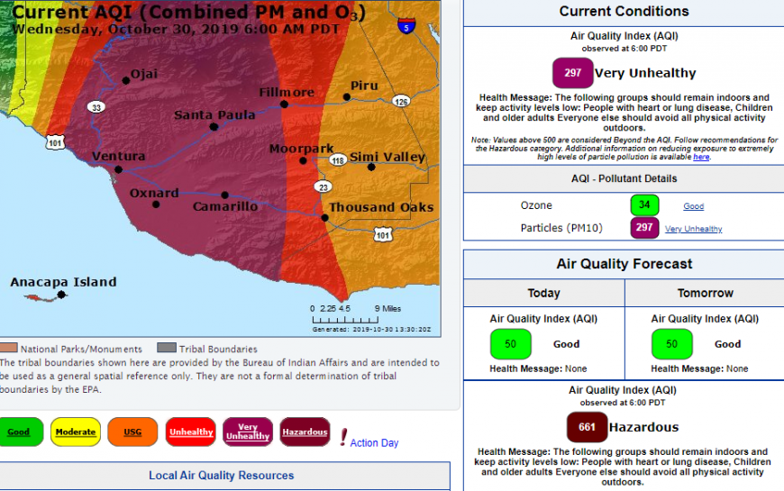
There are seven wildfires burning across California with thick smoke and poor air quality Once more Los Angeles is suffering from wildfires and awaiting Santa Ana winds. The Getty Fire has already hit an area north of Sunset Boulevard, south of Mulholland Drive, in between Beverley Hills and Malibu, CA. Last November Malibu was the area surrounded by fire with houses burning and the university affected. This week an Extreme Red Flag warning has been issued; this does not happen very often.
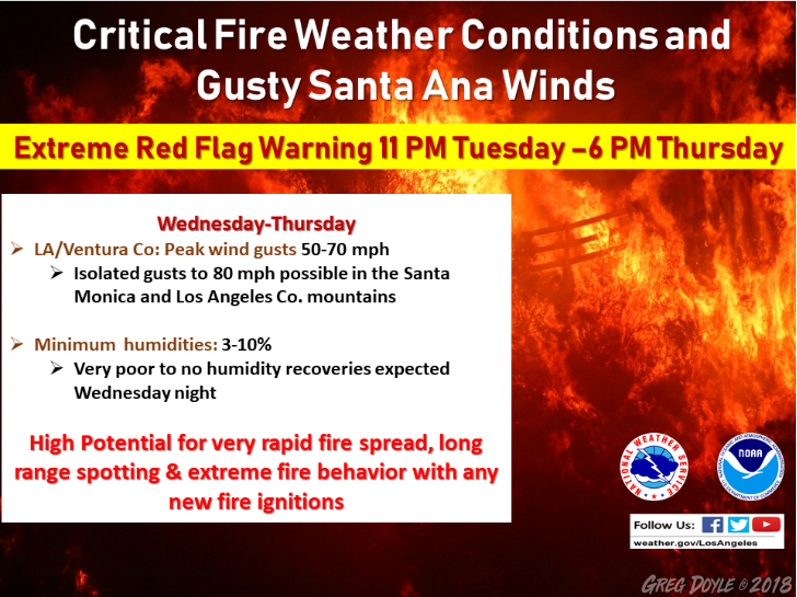
.EXTREME RED FLAG WARNING FROM 11 PM TONIGHT THROUGH 6 PM THURSDAY PDT FOR MUCH OF LOS ANGELES AND VENTURA COUNTIES DUE TO STRONG NORTHEAST WINDS AND VERY LOW HUMIDITIES...
...VERY NEAR CRITICAL CONDITIONS WEDNESDAY MORNING THROUGH THURSDAY MORNING OVER SANTA BARBARA THROUGH SAN LUIS OBISPO COUNTIES
A few homes have burned down and thousands of people have been evacuated from the affected areas. Schools and roads are closed, and power supplies are being interrupted to prevent further sparking before this next wind event.
The Santa Ana winds are strong and dry. They re-ignite or spread existing wildfires and are dreaded by firefighters and homeowners. With wind gusts up to 80mph, these could be the worst situation in over ten years. The forecast is clear and dry, sunny. Temperatures have been around high 70s, low 80s F but there is cooler air moving in.
Still, all three elements of a strong Santa Ana ; Offshore flow, Upper-Level support, Cold air advection are in place. The combination of these three elements will bring warning level gusts (60 to 70 mph mountains 60 mph Valleys) to the windiest areas through noon. (fortunately, the Getty Fire is to the east of the area of strongest winds) Thursday the upper level support and cold air advection are both greatly reduced and the offshore gradients will be weaker. The winds may come in a little weaker than forecast and the warnings in the mtns may need downgrading to advisories. There will be a significant fall off in winds in the afternoon. A hard freeze for Friday morning. Models are not indicating another offshore event in the 10-day period. Unfortunately, there is no rain either.
The LA Fire Dept described "an extreme fire weather threat, meaning that conditions are as dangerous for fire growth and behaviour as we have seen in recent history."
The US National Weather Service (NWS) issue Red Flag Warnings, in conjunction with land management agencies, to alert about ongoing or imminent critical fire weather patterns. NWS issues a Red Flag Warning when fire conditions are ongoing or expected to occur shortly. Parking restrictions occur under these warnings to allow easier travel for the fire tenders and to prevent bottlenecks which have in the past caused panic and deaths in wildfire situations. A Red Flag Day is when the weather conditions are such that the potential for a fast-moving brush fire is extremely high. The conditions are defined as wind speeds 25 mph or more and humidity 15% or less. Over the past years, the maximum number of Red Flag days has been 12 for LA. The average of Red Flag days per year is 4 to 7.
This episode for the end of October 2019 is considered to be an extreme version; the existing fires, the strength of the winds and gusts with the force of the very dry air heading in.
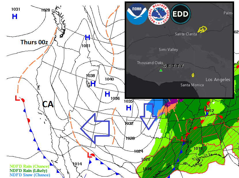
NWS DISCUSSION... A strong Santa Ana wind event is still on target to start quickly tonight and continue through Thursday, with one of the strongest pressure gradients ever and moderate upper level support. Wind will be strongest on Wednesday, when damaging wind gusts between 50 and 70 mph are expected over most of Los Angeles and Ventura Counties, with isolated gusts to around 80 mph likely. Although the air is cold, humidities will lower to the single digits nearly everywhere by Wednesday or Thursday, and down to 1 or 2 percent in the driest windiest locations. Overnight recoveries Wednesday night will be near zero over Los Angeles and Ventura Counties, and poor everywhere else. This all adds up to an extreme fire weather threat, with conditions as dangerous for fire growth and behaviour as we have seen in recent memory...
(Continued) Very dry conditions will persist through the week and could continue into Monday. The offshore flow will weaken quickly Thursday afternoon into the evening but could stay breezy in some mountain and foothill spots into Friday leading to the possibility of localized critical conditions. The cold airmass over the Great Basin and Rockies along with favourable upper level support will set the stage for a strong offshore wind event late tonight through Thursday. It is a cold Santa Ana wind event, not a warm one. Winds will become weak by Thursday night with warmer weather expected over the weekend. There is NO indication of another Santa Ana next week. No rain forecast for the next two weeks. NWS
Loading recent activity...