A look at the ongoing situation in Malibu and other parts of California as the Brush fires continue.
California, known for its sunshine and warmth has again been in the news thanks to fire, brush fires as they are known. You may have seen photos of flames and smoke, stories of celebrities lamenting their destroyed houses or seen Donald Trump's bizarre tweet
These fires have been affecting urban areas, often at the edges in scrubland /brush were dry vegetation and drought conditions combine to a deadly mix. The fire department pointed out there aren’t any forests to manage nearby in a highly populated part of the US.
This area is dry and warm, but weather conditions have become more extreme as the climate changes, the drought lasts longer and southern California is prone to strong dust bearing winds which blow from the desert interior.
High pressure develops over the Great Basin in Utah and Nevada. The air is compressed, warms and speeds up as it flows westwards through the valleys towards the sea. The winds are brisk, gusty and very dry. If this combines with any existing fire issues, then a major incident can result.
Santa Ana Wind: In southern California, a weather condition in which strong, hot, dust-bearing winds descend to the Pacific Coast around Los Angeles from inland desert regions. NWS
There have also been other wildfires on northern California. There are discussions about electric power cables, overhead ones can fall and spark giving the ignition. Money to bury the cables underground is a political hot potato. Fires are part of life here, but as the residents of Malibu in the south are saying “’it’s never been this bad’
In Malibu, there have been evacuations, road closures, red flag restrictions and warnings. People have died and homes razed to the ground.
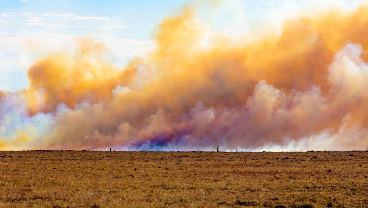
Fire spreads in hot, dry and windy conditions. Higher temperatures and lower relative humidity make any fuels (such as brush) more likely to ignite, the winds bring more oxygen and also move embers to new areas. Spotting is when hot embers can be blown way ahead of the flaming front, starting new fires suddenly in other areas creating a new risk for people evacuating.
Many roads were closed along with the evacuations, mile-long traffic queues as people tried to get away. There are many procedures in place, often learnt and developed from previous events and loss of life.
From the LA fire dept. on Sunday - Red Flag Parking Restrictions a program to remove illegally parked vehicles in posted locations within the Very High Fire Hazard Severity Zones. The parking restrictions are temporary and re-evaluated with the weather conditions.
Station Commanders were asked to survey their district and identify critical areas where parked vehicles could delay citizens trying to evacuate and fire companies attempting to gain access during a Brush Incident. Station Commanders were asked to identify areas such as very narrow roads, hairpin turns, tight curves, and key intersections that, if not cleared of vehicles, would create a choke point.
This has happened before with devastating consequences.
Other warnings related to the evacuations. If you’re in potential fire areas, be prepared to evacuate. Pack a bag with your:
1. ID 2. Medications 3. Birth certificates, marriage certificates, photos 4. Emergency supplies 5. Clothes
There are special animal evacuation centres to allow people to stay elsewhere yet know that their pets or horses are safe.
Evacuation orders were put in place and then are lifted in certain areas to allow some residents to return: repopulation orders. Those affected by the Woolsey Fire had to wait to visit their homes or to see whatever remained.
Pepperdine University in Malibu was affected by the Woolsey Fire with 35,000 students stuck but safe inside for a time, after following a, by then, controversial Shelter in Place policy.
The University disaster awareness page does have quite a list of topics. Those at British campus universities would be surprised. Earthquake, El Nino awareness, active shooter and the Brush Fires.
Part of the Brush Fire advice- “Because of road closures, traffic congestion, and the possibility that the fire may outrun you, it is normally not advisable to leave the Malibu campus during a brush fire. This is referred to as “sheltering-in-place.”
Information from the university pages
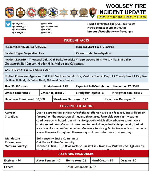
"At this time, the fire is somewhere between five and ten percent contained, and more than 83,000 acres have been burned. The City of Malibu, areas of unincorporated Los Angeles County, and other areas where many of our students and employees live remain under a mandatory evacuation order.
All roads into Malibu including Pacific Coast Highway and all canyon roads remain closed. The National Weather Service has extended the Red Flag Warning through Tuesday, November 13, at 5 PM for gusty northeast winds and very low relative humidity throughout the mountains and coastal areas of Ventura and Los Angeles counties. While we are confident that the University is favourably positioned to manage these conditions, fires remain in areas adjacent to the campus, which are being monitored closely by the University."
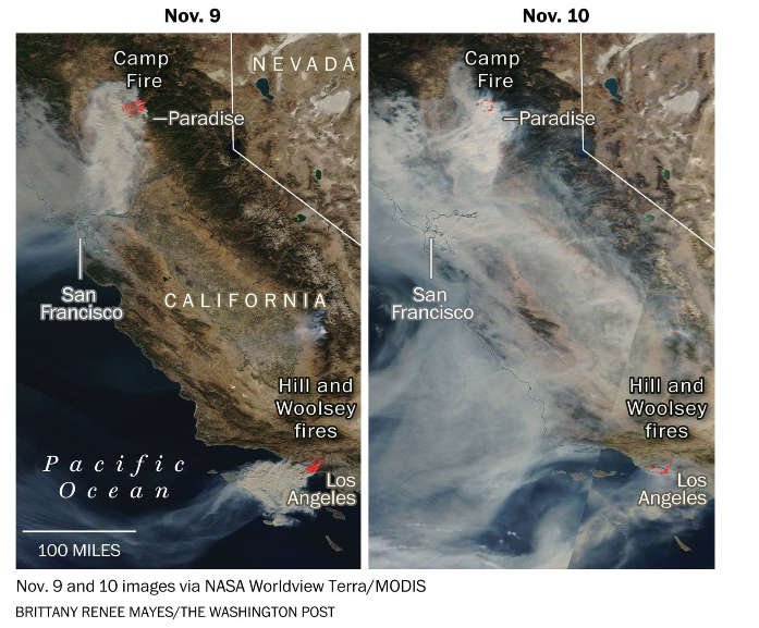
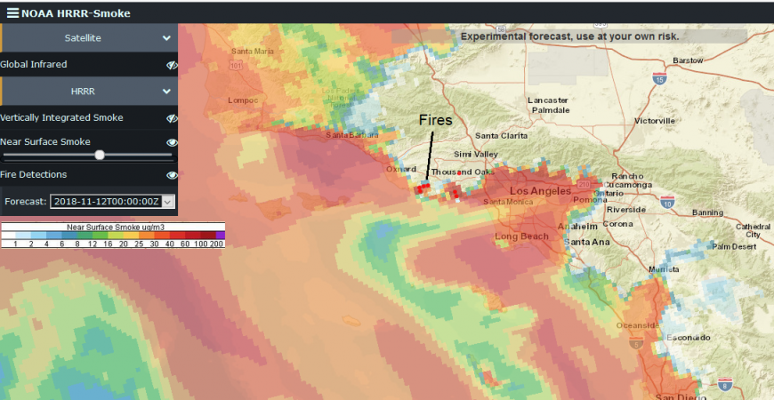
Whilst the actual flames cause alarm, destruction and 2 deaths near Malibu, it is the smoke which has been affecting larger geographical areas and brings further health risks. Near the fires, it leads to disorientation in the danger zones and people fleeing have spoken of their panic as they find it harder to breath or see. The tiny smoke particles get into peoples eyes and lungs leading to chronic diseases. The smoke can travel thousands of miles from the fire sources, so emergency responders are looking to a combination of powerful new NOAA satellite sensors and advanced NOAA weather models to provide accurate forecasts of smoke plumes and planning such as recent closures of Yosemite National Park.
NOAA’s new experimental “HRRR(High-Resolution Rapid Refresh)-Smoke” model is a major advancement in predicting the direction and height of wildfire smoke plumes.
Link to new SMOKE model click on visualisation on interactive map and chose eyes on or off.
POTUS update
Some stunning photos in this blog
The winds will ease for Malibu this week, so that is a bit of good news.
Loading recent activity...