Storm Goretti is on its way. This deepening low pressure will bring gales, heavy rain, sleet and snow. There are numerous warnings for severe weather and likely impacts. Two areas stand out for wind and snow. A red wind warning for the Isles of Scilly and Cornwall from late afternoon into the night has just been issued, which links to a wider yellow wind warning from 3pm across SW Britain and the south coast of England.
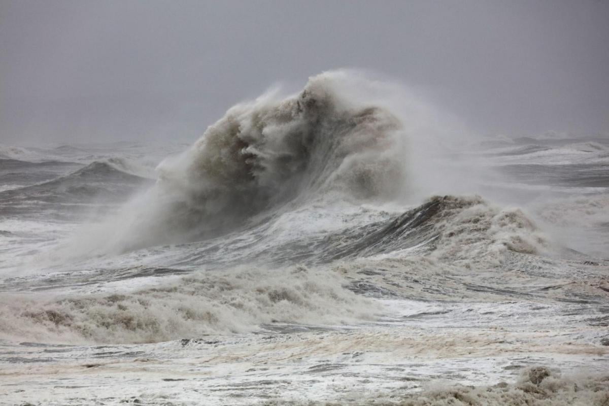
“Storm Goretti will bring dangerous stormy winds for a time on Thursday evening... In addition, very large waves will bring dangerous conditions to some coastal areas.” MO
Earlier today the Council of the Isles of Scilly had advised all members of the public stay at home from 3pm today (Thursday 8 January 2026) due to the forecast gales and deteriorating conditions.
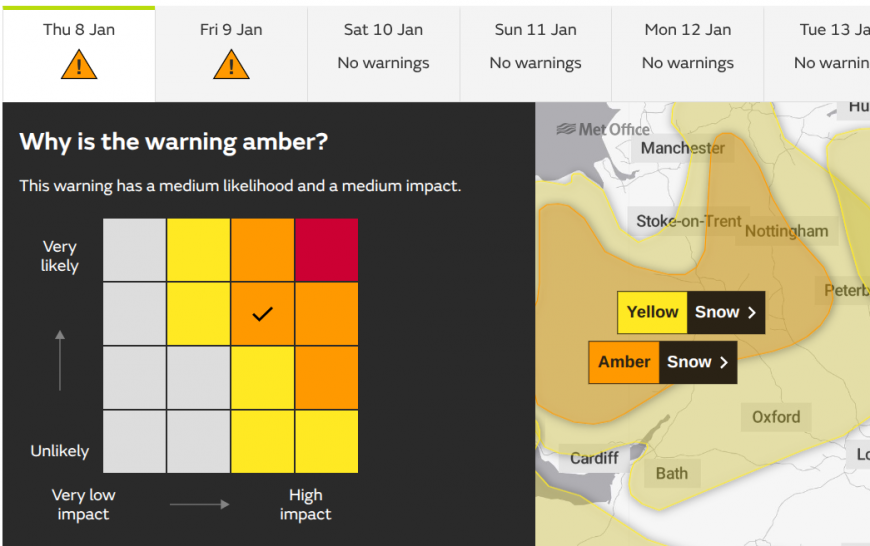
Also an Amber warning for snow focused on inland Wales, the Midlands up into the Peak District and parts Yorkshire, which is also set within a wider yellow warning for snow over more of Wales, central England and up through the Pennines.
“Heavy snow, associated with Storm Goretti, is likely to lead to disruption and dangerous travelling conditions Thursday night into Friday.” MO
Winds
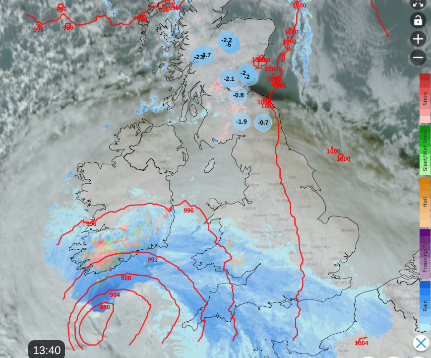
Goretti’s frontal rain is already over southern Britain but as the low centre nears the rain (and snow over the Moors) will ease as the winds increase. For the Amber warning, Cornwall starts with SE winds, as the cyclonic pattern will veer around to the NW this evening.
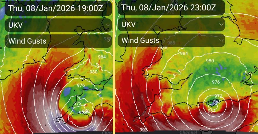
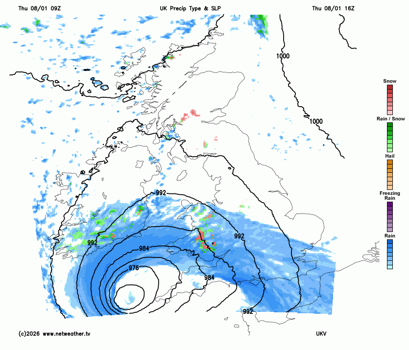
Look how the UKV model shows the Isles of Scilly being battered by the intense wind core. There are still some differences with the models, others keeping the main core through the English Channel but for SW England it is best to be prepared for a stormy evening.
The Inshore Waters forecast (for up to 12 miles offshore around the UK) has an eye-catching
“24 hour forecast: Wind- Cyclonic 4 to 6 increasing severe gale 9 to violent storm 11, but increasing hurricane force 12 for a time at first in west, becoming northwesterly 6 to gale 8 later” with mention of high, even very high seas.
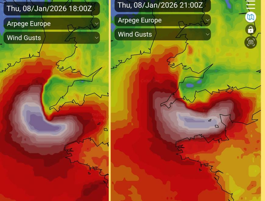
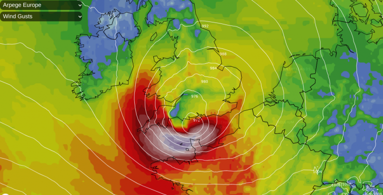
It is an extreme core on the southern flank of the low centre which looks particularly vicious tonight. This is why Meteo France named the low, due to concerns for their north coast. In Normandie, the Manche dept has a red wind warning tonight with coastal flooding and large waves expected. Wind gusts could reach 100mph.
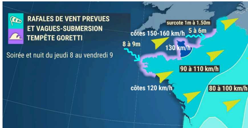
Meteo France are warning of severe gales, gusts of 80 to 100mph with the red warning area for the region to the east of the Channel Islands. High waves with coastal flooding too. Evening and night of Thursday 8th and Friday 9th
For the Channel Islands there is a red wind wrning. The advice is “to stay at home when the wind is at its peak within the period of 8pm Thursday through until the early hours of Friday and to stay away from the coast. High tide is about 10pm Thursday evening with significant waves forecast to affect coastal areas.” Jersey Govt
The Jersey Met forecast mentions W/SW severe gale F9 increasing to storm F10 with gusts to 90mph and the Channel Islands shipping area has a Red wind warning for violent storm F11 along with a flood warning for exposed coastal areas tonight.
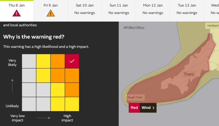
There will be wild conditions tonight as reflected by the High likelihood of High impacts on the warning matrix. The advice is to "keep yourself and others safe; avoid travelling by road during potentially dangerous conditions. It is not safe to drive in these conditions."
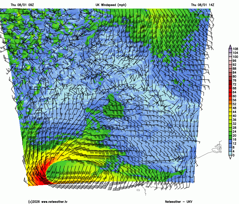
The wind arrows are 10mph for full tail, 5 mph for half and 50mph for a pennant. Gusts will be higher.
Away from the warned areas, it will be a miserable, cold and windy evening and night. An easterly wind picks up ahead of the low across southern Britain, although with light/calm winds near the centre of the low. The red colours on the sequence show 60mph severe gales head along the Channel as a fresh to strong N/NW wind sets in early on Friday. For most people, that will be when you notice Storm Goretti, heading out on Friday. Unless the wind wakes you overnight.
Further north, the winds will be light with clear skies and plummeting temperatures, especially where there is lying snow. Temperatures in the Highlands fell to around -8C last night, Thursday night could see -15C for Scottish glens as Storm Goretti rages in the south.
Rain
Goretti will bring heavy frontal rain and some snow. SW Wales has been highlighted with a yellow rain warning for the risk of flooding as has eastern England. In the east, the warning continues through Friday as the low pressure heads towards the Low Countries and its fronts . There is a low risk of river and surface water flooding in the rain from Goretti and coastal flooding is possible along the English Channel coasts.
Snow
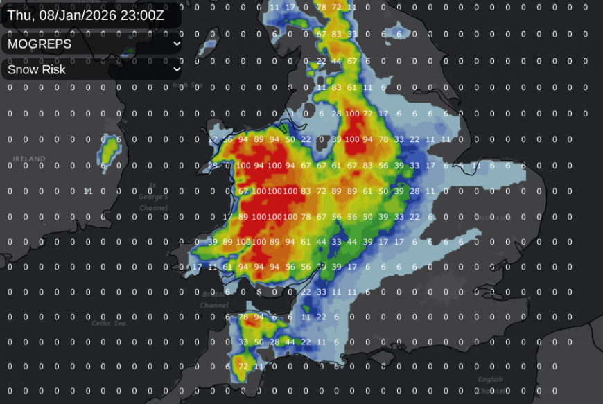
The next hazard overnight into the early hours of Friday will be snow. This part fo the forecast was always going to be tricky. There is cold air in-situ to the north of the incoming frontal rain. Heavy rainfall will lower the temperature allowing pockets of sleet and snow tonight, which will be hard to pin down. Snow is likely over higher ground tonight, for Dartmoor & Exmoor, the Welsh mountains, through the Midlands, into the Peak District, the Yorkshire Dales.
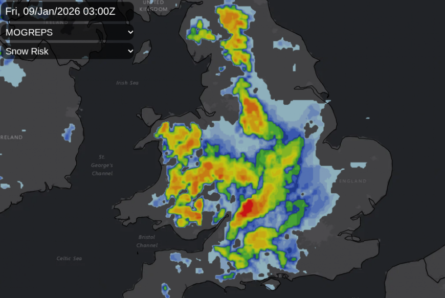
The Cotswolds could see snow before dawn on Friday with sleet and icy rain possible for SE England with snow over the Downs as the low pulls aaway dragging the cold air southwards. The Amber warning highlights an area where the main frontal band meets the cold air, and there will be heavy precipitation overnight which could bring significant snow, even snow at lower levels.
“ Accumulations of 10-15 cm are likely fairly widely, with the potential for 20-30 cm in some locations, mainly on hills above 200 m elevation, more especially in Wales and/or the Peak District. Snow will ease through the course of Friday morning, turning more to rain or sleet at times at low levels, but disruption is likely to persist into Friday after snow stops falling.” MO
There is a wider yellow snow warning, and local routes and driving abilities can result in incidents, not just the amounts of snow falling. It will be windy, wet, potentially wintry so if you do have to travel prepare for getting stuck.
England and Wales will see conditions improving through Friday, although it will stay windy and damp for London, the Home Counties and much of SE Britain in daylight hours. It will feel cold in the northerly flow.
Storm Goretti will move over the Low Countries where there are already warnings; KNMI for the Netherlands “Code orange- Slippery conditions in the north on Friday due to snow and strong winds, locally slippery conditions elsewhere.” RMI Belgium has warnings for rain, wind and ice/snow as the orange warnings for wind continue for much of northern France, including Paris, on Friday morning.
Remember all warnings are for severe weather, they look at likelihood and impacts, not quantitative limits of wind speed or rainfall amounts. As the worst of Goretti will occur overnight, prepare now and the colour of the warning won’t matter too much, just stay indoors unless necessary in the areas which could see the worst of the gales.
What do the warning colours mean? More discussion and chat about Storm Goretti in the community forum
Loading recent activity...